Grange Park, Northamptonshire

Last updated

Grange Park
Grange Park Northampton Community Centre.jpg
Grange Park Community Centre
The Green, Grange Park, Northampton
Northamptonshire UK location map (2021).svg
Red pog.svg
Grange Park
Location within Northamptonshire
Population4,404 (2011 census)
OS grid reference SP675552
  London 65 miles (105 km)
Civil parish
  • Grange Park
Unitary authority
Ceremonial county
Region
Country England
Sovereign state United Kingdom
Post town NORTHAMPTON
Postcode district NN4
Dialling code 01604
Police Northamptonshire
Fire Northamptonshire
Ambulance East Midlands
UK Parliament
Website http://www.grangeparkpc.org
List of places
UK
England
Northamptonshire
52°11′24″N0°52′58″W / 52.18998°N 0.882900°W / 52.18998; -0.882900

Grange Park is a village and a civil parish on the outskirts of Northampton in West Northamptonshire.

Contents

History

The Northampton village was created from agricultural land belonging to Courteenhall Grange Farm [1] in the late 1990s. Approval for the initial development of the Northampton estate was granted on 8 May 1998, initially for one thousand houses to be built along with amenities such as a primary school, a community centre, and country parks. [2]

2003 planned development of an IKEA store

In 2003, a sand pit which was a former domestic refuse site was the proposed location for a new IKEA store [3] but after local opposition from members of the public, the store was built in Milton Keynes instead. [3] [4]

2008 development of 450 new homes

In 2008, West Northamptonshire Development Corporation agreed on a new development of 450 new homes and a hotel in the same sand pit location where an IKEA store was planned in 2003 but the government decided that the 450 new homes would be built closer to the existing homes in the village rather than on the wasteland. [5]

2017 warehouses development

In 2017, three new warehouses were built in the sandpit location that was formerly the planned site for an IKEA and 450 new homes. Two of the warehouses are home to Clipper Logistics and the other one is home to an Amazon UK distribution centre.

2019 planned development of 330 new homes

In January 2019, Manor Oak Homes published plans for 330 new homes. [6] Most of the community are not opposed to the new development but many believe that there are not enough local services to cope with the new homes as the primary school, doctor's surgery, dental practice and pre-school are already at almost full capacity and with the 330 new homes, there are no new plans for further community buildings.[ citation needed ]

Demographics

The population of Grange Park was 4,404 as of the 2011 Census. Prior to this, according to the 2001 Census the population was just 327 people, however the Northampton estate was relatively undeveloped at that time. A census is taken every ten years in the United Kingdom, the next one will be in the year 2021.

In the 2011 Census, 82.8% of the Grange Park population identified themselves as White British.

Facilities

Schools

Woodland View Primary School is the only school in Grange Park, it caters for children in primary education from reception up until Year 6. For Secondary education, most children go to Caroline Chisholm School but there are numerous other secondary schools in the area that children can go to.

Community

The estate has numerous community facilities such as a community centre, a sports pavilion and a religious centre. These are home for numerous clubs and youth groups such as Scouts and sports clubs.

There is also a doctors surgery, a dental practice and a daycare for members of the community to use.

Commercial

Grange Park have a Co-op Food supermarket, a Harvester restaurant, a marstons pub and some take away establishments. There are also two hotels in Grange Park which are in a prime location for business persons due to how close the Northampton estate is to the M1 motorway.

Industrial

There is a small industrial estate in Grange Park which contain numerous warehouses used as distribution centres for logistics companies. There are also three warehouses that are outside of the industrial estate which are operated by Clipper and Amazon. Grange Park is also a prime location as a logistics hub due to how close the M1 motorway and the A45 trunk road are.

Politics

Parish council

Grange Park Parish Council has 12 members who are elected every four years. [7]

Unitary Authority

Following local government restructuring the Northampton estate is governed by West Northamptonshire council. Prior to this it was in the South Northamptonshire and had two councillors who were responsible for "Grange Ward". Councillor Andrew Grant and Councillor Adil Sadygov both members of the Conservative party. [8] It was also represented on Northamptonshire County Council by one councillor who was responsible for "Hackleton and Grange Park Ward". The last councillor for this ward was Councillor Michael Clarke, a member of the Conservative party. [9]

Transport

Grange Park is close to the Northampton loop of the West Coast Main Line. This carries trains from Northampton to London Euston via Milton Keynes Central.

Peak travel times by rail by West Midlands Trains and Avanti West Coast services in minutes are: from Northampton to Central London 46, to Birmingham 65; from Milton Keynes to Central London 40 and Manchester 120.

The estate borders on the M1 motorway to the south-east and A45 to the west and north.

Typical travel times in minutes by road (peak times in italics) are:

Airports at Heathrow, Gatwick, and London Stansted as well as Birmingham Airport are all within easy reach.

Grange Park is also on the Stagecoach Midlands X6 bus route between Milton Keynes and Northampton via Roade. The main local routes for the area also include the routes 11/11A which also bypass Wootton and Hardingstone.

Related Research Articles

<span class="mw-page-title-main">Northamptonshire</span> County of England

Northamptonshire is a ceremonial county in the East Midlands of England. It is bordered by Leicestershire, Rutland and Lincolnshire to the north, Cambridgeshire to the east, Bedfordshire, Buckinghamshire, Oxfordshire to the south and Warwickshire to the west. Northampton is the largest settlement and the county town.

<span class="mw-page-title-main">Daventry</span> Market town and civil parish in Northamptonshire, England

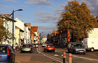
Daventry is a market town and civil parish in the West Northamptonshire unitary authority area of Northamptonshire, England, close to the border with Warwickshire. At the 2021 Census, Daventry had a population of 28,123, making it the sixth-largest town in Northamptonshire.

<span class="mw-page-title-main">Newport Pagnell</span> Human settlement in England

Newport Pagnell is a town and civil parish in the City of Milton Keynes, Buckinghamshire, England. The Office for National Statistics records Newport Pagnell as part of the Milton Keynes urban area.

<span class="mw-page-title-main">Ashton, West Northamptonshire</span> Human settlement in England

Ashton is a village in West Northamptonshire about 1 mile (1.6 km) southeast of Roade village close to the Northampton to Milton Keynes A508, ca.3 miles (5 km) south of junction 15 of the M1 motorway, 6 miles (10 km) south of Northampton and 11 miles (18 km) north of Milton Keynes. The population of the civil parish at the 2011 census was 395. The village is about 67 miles (107.8 km) north of London via the M1 junction 15. The West Coast Main Line intersects the village on its eastern side.

<span class="mw-page-title-main">Harpole</span> Human settlement in England

Harpole is a village 4 miles (6.4 km) west of Northampton, England, along the A4500 road about 1 mile (1.6 km) east of the M1 Motorway junction 16.

Wootton is a former village about 3 miles (4.8 km) south of Northampton town centre that is now part of Northampton.

<span class="mw-page-title-main">Milton Malsor</span> Human settlement in England

Milton Malsor is a village and civil parish in West Northamptonshire, England. The population of the civil parish at the 2011 census was 761. It is 4 miles (6.4 km) south of Northampton town centre, 45 miles (72 km) south-east of Birmingham, and 66 miles (106 km) north of central London; junction 15 of the M1 motorway is 2 miles (3.2 km) east by road. The area of the Milton Malsor civil parish is about 1,650 acres (670 ha), stretching from north of the M1 motorway between junctions 15 and 15A, south to the West Coast Main Line, east to the A508 and A45 roads, and west to the A43 road.

<span class="mw-page-title-main">A43 road</span> Road in England

The A43 is a primary route in the English Midlands and northern South East England, that runs from the M40 motorway near Ardley in Oxfordshire to Stamford in Lincolnshire. Through Northamptonshire it bypasses the towns of Northampton, Kettering and Corby which are the three principal destinations on the A43 route. The A43 also links to the M1 motorway.

<span class="mw-page-title-main">Hartwell, Northamptonshire</span> Human settlement in England

Hartwell is a village and civil parish in West Northamptonshire, England, bordering Buckinghamshire. The village is next to Salcey Forest and the M1 motorway. It is 7 miles (11 km) south of Northampton and 13 miles (21 km) north of Milton Keynes.

<span class="mw-page-title-main">Blisworth</span> Human settlement in England

Blisworth is a village and civil parish in the West Northamptonshire, England. The West Coast Main Line, from London Euston to Manchester and Scotland, runs alongside the village partly hidden and partly on an embankment. The Grand Union Canal passes through the village and the north portal of the Blisworth tunnel is near Stoke Road.

West Hunsbury is a housing estate in the south of Northampton, England, situated around 2 miles (3 km) away from the town centre, and 0.5 miles (1 km) away from the M1 via junction 15A. It is part of the Hunsbury residential area, which also constitutes East Hunsbury east of Towcester Road. Shelfleys is an earlier name for the area and still appears on signs, maps and bus destination indicators. However Hunsbury is an old name. Iron ore was formerly quarried in the area. This had begun by 1873 and an ironworks called Hunsbury Ironworks was in the course of being built in that year. The quarries were worked by several companies and individual owners, two of which companies used the name "Hunsbury" in their titles. The area is part of the Borough of Northampton. The area was developed in the 1970s, 1980s, 1990s and 2000s as part of the expansion of Northampton.

<span class="mw-page-title-main">Abington, Northamptonshire</span> Suburb in Northampton, England

Abington is a district of the town of Northampton and former civil parish, now in the parish of Northampton, in the West Northamptonshire district, in the ceremonial county of Northamptonshire, England, situated about 2 miles (3.2 km) east of the town centre. The population of the ward of Northampton Borough Council at the 2011 census was 9,668.

<span class="mw-page-title-main">Roade</span> Village in West Northamptonshire, England

Roade is a village in Northamptonshire, England. Currently in West Northamptonshire, before local government changes in 2021 it was represented by South Northamptonshire District Council, falling within the two-member Blisworth and Roade ward.

<span class="mw-page-title-main">Collingtree</span> Village in Northamptonshire, England

Collingtree is a village and civil parish in the West Northamptonshire district of Northamptonshire, England. It is part of the Northampton built-up area.

<span class="mw-page-title-main">East Hunsbury</span> Human settlement in England

East Hunsbury is a large residential area in the south of Northampton, England, situated around 3 miles (5 km) from the town centre and 1 mile (2 km) from junction 15 of the M1 motorway. For administrative purposes it is part of the unitary authority of West Northamptonshire. It is part of the Hunsbury conglomeration, which also includes West Hunsbury on the west side of Towcester Road. Shelfleys is the original name for the area of Northampton currently referred to as West Hunsbury. The name of West Hunsbury still appears on maps for the district as Shelfleys. Merefield is the corresponding name for East Hunsbury, together with the name "Blacky More" for the eastern part of East Hunsbury. All three names are still on local direction signs in Northampton, although older references are no longer in use by the local people living there. The areas developed in the 1980s and 1990s as part of the expansion of Northampton. The Northampton loop of the West Coast Main Line railway running between Northampton and London Euston runs under East and West Hunsbury via the Hunsbury Hill Tunnel emerging near Hill Farm Rise which follows the original course of Towcester Road prior to the 1980s. Ventilation shafts are visible in the housing estate in Yeoman Meadow. East Hunsbury was awarded ‘Best Large Village’ in 2019 by NorthantsAcre.

Kislingbury is a village in Northamptonshire, England, about 4 miles (6 km) west of Northampton town centre, and close to junctions 15A and 16 of the M1 motorway.

<span class="mw-page-title-main">Courteenhall</span> Village in Northamptonshire, England

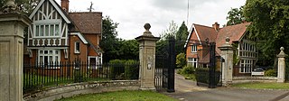
Courteenhall is a village 5 miles (8 km) south of the county town of Northampton, in the shire county of Northamptonshire, England, and about 66 miles (106 km) north of London. The population of the civil parish was 122 at the 2011 census. The village is located in a cul-de-sac.

<span class="mw-page-title-main">Collingtree Park</span> District in England

Collingtree Park is a district in the Borough of Northampton in the East Midlands of England.

<span class="mw-page-title-main">West Northamptonshire</span> District in England

West Northamptonshire is a unitary authority area covering part of the ceremonial county of Northamptonshire, England, created in 2021. By far the largest settlement in West Northamptonshire is the county town of Northampton. Its other significant towns are Daventry, Brackley and Towcester; the rest of the area is predominantly agricultural villages though it has many lakes and small woodlands and is passed through by the West Coast Main Line and the M1 and M40 motorways. The district includes the site of the Roman town of Bannaventa, and the grade I listed Althorp House and its estate.

The golden logistics triangle is an area of the English Midlands containing a high number of logistics and warehousing facilities. It originally referred to a small area around Lutterworth, Leicestershire, but various definitions have set areas across the East and West Midlands, as far north as Yorkshire and as far south as Milton Keynes. The Office for National Statistics uses a definition of any area within 4 hours driving distance of 90% of the British population, which gives a non-contiguous area in the West Midlands.

References

  1. "Map 1952". National Library of Scotland Ordnance Survey Map Archive. Retrieved 17 April 2018.
  2. "History". Grange Park Parish Council, Northamptonshire. Retrieved 25 March 2017.
  3. 1 2 "Grange Park Parish Council - history 2002" . Retrieved 25 September 2008.
  4. ""Housing gateway bid for Ikea site" - Northampton Chronicle & Echo" . Retrieved 25 September 2008.
  5. ""Go-ahead for 450 new homes in Grange Park" - Northampton Chronicle & Echo" . Retrieved 25 September 2008.
  6. Manor Oak Homes - Grange Park Consultation, January 2019
  7. "Councillors". grangeparkpc.org. 4 April 2019. Retrieved 26 September 2019.
  8. "Your Councillors | South Northamptonshire Council". modgov.southnorthants.gov.uk. Retrieved 26 September 2019.
  9. "Councillors". cmis.northamptonshire.gov.uk. Retrieved 26 September 2019.

Sources