Mears Ashby

Last updated

Mears Ashby
Mears Ashby Hall.png
Northamptonshire UK location map (2021).svg
Red pog.svg
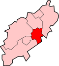
Mears Ashby
Location within Northamptonshire
Population473  (2011 census)
OS grid reference SP838666
Unitary authority
Ceremonial county
Region
Country England
Sovereign state United Kingdom
Post town NORTHAMPTON
Postcode district NN6
Dialling code 01604
Police Northamptonshire
Fire Northamptonshire
Ambulance East Midlands
UK Parliament
List of places
UK
England
Northamptonshire
52°17′36″N0°46′19″W / 52.29335°N 0.77205°W / 52.29335; -0.77205

Mears Ashby is a village in the county of Northamptonshire, England. [1] It lies between the county town of Northampton and Wellingborough and was in the West ward of borough council of Wellingborough area which also included Sywell prior to local government reform in 2021. At the time of the 2011 census, it had a population of 473. [2]

Contents

The villages name means 'Ash-tree farm/settlement' or perhaps, 'Aski's farm/settlement'. The village was held by Robert de Mares in 1242. [3]

Mears Ashby Hall and Estate

Located to the south of the village is Mears Ashby Hall, a fine Grade II* listed Jacobean Manor House. [4] The Hall was built in 1637 and was owned by the Stockdale family (Stockdale Baronets), [5] who descend from the Yorkshire landowning family of the same name. [6] In 1859 the East Wing by Anthony Salvin was added by Henry Stockdale. [7] During the 1980s the Hall became known for performances of Operatic Music organised by Frederick Stockdale. The long association of the Stockdale family at Mears Ashby Hall ended when in the 1990s when the house was sold and Hoddington House became the principal family residence. There are a number of windows in the village church commissioned by Sir Edmund Stockdale by noted stained glass artist Lawrence Lee which depict the family's links to the village. [8]

Witchcraft

According to Westwood and Simpson in their book, The Lore of the Land, the county in general and Mears Ashby, in particular, has a long tradition of witchcraft and accusations of witchcraft. In their book they recall that as late as 1785 a local inhabitant, Sarah Bradshaw, was so accused. We learn from the Northampton Mercury on 1 August 1785 that:

Thursday last, a poor woman, named Sarah Bradshaw of Mears Ashby...who was accused by some of her neighbours of being a witch, in order to prove her innocence, submitted to the ignominy of being dipped (on a ducking-stool); when she immediately sunk to the bottom of the pond; which was deemed an incontestable proof that she was no witch!

Further reading

Related Research Articles

<span class="mw-page-title-main">Northamptonshire</span> County of England

Northamptonshire is a ceremonial county in the East Midlands of England. It is bordered by Leicestershire, Rutland, and Lincolnshire to the north, Cambridgeshire to the east, Bedfordshire, Buckinghamshire, Oxfordshire to the south, and Warwickshire to the west. Northampton is the largest settlement and the county town.

<span class="mw-page-title-main">Wellingborough</span> Market town in Northamptonshire, England

Wellingborough is a market town and civil parish in the North Northamptonshire unitary authority area of Northamptonshire, England. It is 65 miles (105 km) from London and 11 miles (18 km) from Northampton, and is on the north side of the River Nene.

<span class="mw-page-title-main">Borough of Wellingborough</span> Former borough in England

The Borough of Wellingborough was a non-metropolitan district and borough in Northamptonshire, England, from 1974 to 2021. It was named after Wellingborough, its main town, but also included surrounding rural areas.

<span class="mw-page-title-main">Canons Ashby</span> Human settlement in England

Canons Ashby is a small village and civil parish in West Northamptonshire, England. The population of the village is included in the civil parish of Preston Capes.

<span class="mw-page-title-main">Ravensthorpe, Northamptonshire</span> Human settlement in England

Ravensthorpe is a village and civil parish in West Northamptonshire in England. The village lies approximately midway between Northampton and Rugby. The M1 motorway is six miles west and the nearest railway station is at Long Buckby. At the time of the 2001 census, the parish's population was 656 people, including Coton but falling slightly to 646 at the 2011 census.

<span class="mw-page-title-main">Guilsborough</span> Human settlement in England

Guilsborough is a village and civil parish in West Northamptonshire in England. At the time of the 2001 census, the parish's population was 882 people, reducing to 692 at the 2011 Census.

Cold Ashby is a village and civil parish in West Northamptonshire in England. At the time of the 2001 census, the parish's population was 255 people, increasing to 278 at the 2011 census.

<span class="mw-page-title-main">Grendon, Northamptonshire</span> Human settlement in England

Grendon is a small village and civil parish in rural Northamptonshire, England, on the borders of Bedfordshire and Buckinghamshire. Many houses are made of the local limestone and various older thatched houses survive. The name of the village means "green hill" and today the village remains centred on the hill. As with Earls Barton, the village was owned by Judith, the niece of William the Conqueror.

<span class="mw-page-title-main">West Clandon</span> Human settlement in England

West Clandon is a village in Surrey, England within 1 mile of the A3. It is situated one mile north west of the much smaller separate village of East Clandon.

Wootton is a former village about 3 miles (4.8 km) south of Northampton town centre that is now part of Northampton.

<span class="mw-page-title-main">Adstone</span> Human settlement in England

Adstone is a village and civil parish in West Northamptonshire, England. The population at the 2001 census was 65. It remained than 100 at the 2011 census and was included in the civil parish of Tiffield. Adstone is situated approximately 6.5 miles (10 km) south-southeast of Daventry and 6.5 miles (10 km) west-northwest of Towcester. It was known as Atenestone in the Domesday Book.

<span class="mw-page-title-main">Ecton, Northamptonshire</span> Human settlement in England

Ecton is a village and civil parish in North Northamptonshire, England. The village is just east of Northampton, just off the A4500 road. It was one of the first villages in Northamptonshire to be given conservation status. The toponym is derived from the Old English words Ecca and tun, meaning "Ecca's farm/settlement."

Earls Barton is a village and civil parish in Northamptonshire, notable for its Anglo-Saxon church and shoe-making heritage. The village is in North Northamptonshire and was previously in the Borough of Wellingborough until 2021. At the time of the 2011 census, the population was 5,387. Earls Barton is renowned for its remarkable Anglo-Saxon heritage.

<span class="mw-page-title-main">Irchester</span> Village in Northamptonshire, England

Irchester is a village and civil parish in North Northamptonshire, two miles (3 km) south-east of Wellingborough and two miles south-west of Rushden. The population of the village at the 2011 Census was 5,706 and estimated in 2019 at 5,767. Little Irchester and Knuston also lie in the parish.

<span class="mw-page-title-main">Abington, Northamptonshire</span> Suburb in Northampton, England

Abington is a district of the town of Northampton and former civil parish, now in the parish of Northampton, in the West Northamptonshire district, in the ceremonial county of Northamptonshire, England, situated about 2 miles (3.2 km) east of the town centre. The population of the ward of Northampton Borough Council at the 2011 census was 9,668.

<span class="mw-page-title-main">North Northamptonshire</span> District in England

North Northamptonshire is one of two local government districts in Northamptonshire, England. It is a unitary authority area forming about one half of the ceremonial county of Northamptonshire. It was created in 2021. Its council is based in Corby, the district's largest town. Other notable towns are Kettering, Wellingborough, Rushden, Raunds, Desborough, Rothwell, Irthlingborough, Thrapston and Oundle.

<span class="mw-page-title-main">West Northamptonshire</span> District in England

West Northamptonshire is a unitary authority area covering part of the ceremonial county of Northamptonshire, England, created in 2021. By far the largest settlement in West Northamptonshire is the county town of Northampton. Its other significant towns are Daventry, Brackley and Towcester; the rest of the area is predominantly agricultural villages though it has many lakes and small woodlands and is passed through by the West Coast Main Line and the M1 and M40 motorways. The district includes the site of the Roman town of Bannaventa, and the grade I listed Althorp House and its estate.

<span class="mw-page-title-main">Pendleton, Lancashire</span> Human settlement in England

Pendleton is a small village and civil parish in Ribble Valley, within the county of Lancashire, England. It is close to the towns of Whalley and Clitheroe. The parish lies on the north west side of Pendle Hill below the Nick o' Pendle. The village is just off the A59, Liverpool to York main road, since the construction of the Clitheroe By-Pass. Older roads through the parish include one from Clitheroe to Whalley which passes through the Standen area and another to Burnley which passes Pendleton Hall.

<span class="mw-page-title-main">Northamptonshire witch trials</span>

The Northamptonshire witch trials mainly refer to five executions carried out on 22 July 1612 at Abington Gallows, Northampton. In 1612 at the Lent Assizes held in Northampton Castle a number of women and a man were tried for witchcraft of various kinds, from murder to bewitching of pigs. There are two main accounts of these witches being tried. However they differ on how many witches were tried, who they were and exactly what they were supposed to have done.

Sir Edmund Villiers Minshull Stockdale, 1st Baronet was an English banker who served as the 632nd Lord Mayor of London from 1959 to 1960.

References

  1. Ordnance Survey: Landranger map sheet 152 Northampton & Milton Keynes (Buckingham & Daventry) (Map). Ordnance Survey. 2014. ISBN   9780319231715.
  2. "Office of National Statistics: Mears Ashby CP: Parish headcounts". Archived from the original on 16 July 2015. Retrieved 16 July 2015.
  3. http://kepn.nottingham.ac.uk/map/place/Northamptonshire/Mears%20Ashby
  4. "Mears Ashby Hall | History". mearsashbyhall.com. Retrieved 18 April 2018.
  5. Sawbridge. Stockdale family of Mears Ashby Hall. Northants: Northamptonshire Archives. pp. 1–5.
  6. Burke, Bernard (1871). A Genealogical and Heraldic History of the Landed Gentry of Great ..., Volume 2. London: Burkes. p. 1322.
  7. https://www.bbc.co.uk/history/domesday/dblock/GB-480000-264000/page/13.{{cite web}}: Missing or empty |title= (help)
  8. "All Saints, Mears Ashby". www.mearsashbygroup.org.uk. Church of England. Retrieved 3 May 2019.