Y. S. Rao

Last updated

Y. S. Rao
YSRao.jpg
Born
India
NationalityIndian
CitizenshipIndia
Alma mater Andhra University
IIT Bombay
Known for Synthetic Aperture Radar (SAR) interferometry, Satellite crop monitoring
Scientific career
Fields Remote sensing
Institutions IIT Bombay
Websitewww.csre.iitb.ac.in/ysrao

Dr. Y. S. Rao is a professor at the Centre of Studies in Resources Engineering, Indian Institute of Technology Bombay, Mumbai, India. [1] [2] [3] He is working in the field of microwave remote sensing and land based applications for more than 34 years. [4] His early research was focused on the use of Synthetic Aperture Radar (SAR) interferometry for landslides and land deformation monitoring, Digital Elevation Model generation, snow and glacier monitoring. He is also actively involved in developing several techniques for soil moisture estimation using passive and active microwave remote sensing data for more than 25 years. [4] His current research involves SAR Polarimetry for crop characterization, classification, biophysical parameter retrieval using linear and compact-pol [5] SAR data. Apart from applications, he has also contributed in the field of Polarimetric SAR system calibration and software tool development. [6] [4] [7]

Contents

Education

Rao received the M.Sc. degree in physics from Andhra University, Visakhapatnam, India, in 1982, and the Ph.D. degree in passive microwave remote sensing of soil moisture from the Indian Institute of Technology (IIT) Bombay, Mumbai, India, in 1992. [2] [8]

Professional career

He joined the Centre of Studies in Resources Engineering, Indian Institute of Technology Bombay, in 1985, as a senior research assistant and then became a research scientist in 1999. During 2005–2009, he was a senior research scientist and then associate professor from 2009 to 2014. He is currently a professor since 2015. [1] [2] He was engaged in both passive and active microwave remote sensing for several applications viz. soil moisture, [9] [10] [11] [12] [13] flood mapping, [14] and crop inventory mapping. [15] [16] He has participated in several space borne campaigns for collecting synchronous ground-truth data and has experience in handling various data set for several applications of cryosphere, [17] [18] [19] [20] agriculture, [21] [22] water-resources. [23] [24] His current research interests include application of polarimetry for geophysical parameter retrieval [25] [23] and SAR interferometry for DEM [26] [27] and land deformation. [28]

He is actively involved in teaching several courses including Principles of Remote Sensing, Microwave Remote Sensing, Atmospheric Remote Sensing, Advanced Concepts in Polarimetric SAR Data Analysis for M.Tech. and Ph.D. students for the last 12 years. [1] He is also invited for lectures/training programs in several Institutes/Universities. He has conducted numerous training programmes for Indians on SAR and InSAR related activities as a member of task group, and also organized international programmes with the help of DLR Germany, CNES France and University of Cape Town, South Africa. [4]

He supervises doctoral and masters research on both PolSAR and InSAR applications. Dr. Rao is the principal and co-principal investigator of numerous projects sponsored by European Space Agency (ESRIN/ESA); German Aerospace Centre (DLR); the Department of Science and Technology (DST), Government of India; Snow & Avalanche Study Estt (SASE), Defence Electronics Application Laboratory (DEAL), Electronics and Radar Development Establishment (LRDE)- Defense Research and Development Organization (DRDO), Government of India; Indian Space Research Organization (ISRO); Society for Applied Microwave Electronics Engineering & Research (SAMEER), Ministry of Electronics & Information Technology, Government of India; and GEOGLAM-JECAM SAR Inter-Comparison Experiment. [4] He has authored more than 100 scientific publications in refereed international-national journals and conference proceedings.[ citation needed ]

Related Research Articles

<span class="mw-page-title-main">Synthetic-aperture radar</span> Form of radar used to create images of landscapes

Synthetic-aperture radar (SAR) is a form of radar that is used to create two-dimensional images or three-dimensional reconstructions of objects, such as landscapes. SAR uses the motion of the radar antenna over a target region to provide finer spatial resolution than conventional stationary beam-scanning radars. SAR is typically mounted on a moving platform, such as an aircraft or spacecraft, and has its origins in an advanced form of side looking airborne radar (SLAR). The distance the SAR device travels over a target during the period when the target scene is illuminated creates the large synthetic antenna aperture. Typically, the larger the aperture, the higher the image resolution will be, regardless of whether the aperture is physical or synthetic – this allows SAR to create high-resolution images with comparatively small physical antennas. For a fixed antenna size and orientation, objects which are further away remain illuminated longer - therefore SAR has the property of creating larger synthetic apertures for more distant objects, which results in a consistent spatial resolution over a range of viewing distances.

The FLuorescence EXplorer (FLEX) is a planned mission by the European Space Agency to launch a satellite to monitor the global steady-state chlorophyll fluorescence in terrestrial vegetation. FLEX was selected for funding on 19 November 2015 and will be launched on a Vega C rocket from Guiana Space Centre in mid-2025.

<span class="mw-page-title-main">OpenEV</span>

OpenEV is an open-source geospatial toolkit and a frontend to that toolkit. OpenEV was developed using Python and uses the GDAL library to display georeferenced images and elevation data. The application also has image editing capabilities and uses OpenGL to display elevation data in three-dimensions.

<span class="mw-page-title-main">GNSS reflectometry</span> Earth observation technology

GNSS reflectometry involves making measurements from the reflections from the Earth of navigation signals from Global Navigation Satellite Systems such as GPS. The idea of using reflected GNSS signal for earth observation became more and more popular in the mid-1990s at NASA Langley Research Center and is also known as GPS reflectometry. Research applications of GNSS-R are found in

<span class="mw-page-title-main">Mission Science Division</span>

The Earth and Mission Science Division is a group of European Space Agency (ESA) staff mission scientists, contractors, research fellows, young graduates, trainees, and administrative staff working within the Science, Applications and Climate Department of the Directorate of Earth Observation Programmes. The Division is located at ESA's European Space Research and Technology Centre in Noordwijk, South Holland, The Netherlands.

Sea ice concentration is a useful variable for climate scientists and nautical navigators. It is defined as the area of sea ice relative to the total at a given point in the ocean. This article will deal primarily with its determination from remote sensing measurements.

The Cyclone Global Navigation Satellite System (CYGNSS) is a space-based system developed by the University of Michigan and Southwest Research Institute with the aim of improving hurricane forecasting by better understanding the interactions between the sea and the air near the core of a storm.

The Canada Centre for Mapping and Earth Observation (CCMEO) (formerly Canada Centre for Remote Sensing (CCRS)) is a branch of Natural Resources Canada's Earth Science Sector. It was created in 1970 with Lawrence Morley as the first Director General. The department also works closely with the private sector, especially with the development of GIS software.

JoBea Way Holt is an American planetary scientist who has worked for NASA. Holt studied the carbon cycle in Earth's atmosphere. She is also a member of the Climate Project, and is the author of several books and research papers.

Frank Silvio Marzano was a professor at the Sapienza University of Rome, Italy who was named Fellow of the Institute of Electrical and Electronics Engineers (IEEE) in 2016 for contributions to microwave remote sensing in meteorology and volcanology. He was also a Fellow of the UK Royal Meteorological Society since 2012. In 2020 Dr. Marzano was inserted in the World's Top 2% Scientists database of Stanford University (USA).

The railSAR, also known as the ultra-wideband Foliage Penetration Synthetic Aperture Radar, is a rail-guided, low-frequency impulse radar system that can detect and discern target objects hidden behind foliage. It was designed and developed by the U.S. Army Research Laboratory (ARL) in the early 1990s in order to demonstrate the capabilities of an airborne SAR for foliage and ground penetration. However, since conducting accurate, repeatable measurements on an airborne platform was both challenging and expensive, the railSAR was built on the rooftop of a four-story building within the Army Research Laboratory compound along a 104-meter laser-leveled track.

The boomSAR is a mobile ultra-wideband synthetic aperture radar system designed by the U.S. Army Research Laboratory (ARL) in the mid-1990s to detect buried landmines and IEDs. Mounted atop a 45-meter telescoping boom on a stable moving vehicle, the boomSAR transmits low frequency short-pulse UWB signals over the side of the vehicle to scope out a 300-meter range area starting 50 meters from the base of the boom. It travels at an approximate rate of 1 km/hour and requires a relatively flat road that is wide enough to accommodate its 18 ft-wide base.

Mahta Moghaddam is an Iranian-American electrical and computer engineer and William M. Hogue Professor of Electrical Engineering in the Ming Hsieh Department of Electrical and Computer Engineering at the University of Southern California Viterbi School of Engineering. Moghaddam is also the president of the IEEE Antennas and Propagation Society and is known for developing sensor systems and algorithms for high-resolution characterization of the environment to quantify the effects of climate change. She also has developed innovative tools using microwave technology to visualize biological structures and target them in real-time with high-power focused microwave ablation.

<span class="mw-page-title-main">Avik Bhattacharya</span> Microwave remote sensing specialist

Avik Bhattacharya is a professor at the Centre of Studies in Resources Engineering, Indian Institute of Technology Bombay, Mumbai, India. He has been working in the field of radar polarimetry theory and applications for more than a decade. His main focuses on the use of synthetic aperture radar (SAR) data for land use classification, change detection and qualitative and quantitative biophysical and geophysical information estimation.

<span class="mw-page-title-main">Eni G. Njoku</span> American scientist

Eni G. Njoku is a Nigerian-American scientist specializing in microwave remote sensing. He worked at the Jet Propulsion Laboratory (JPL), California Institute of Technology, where he was responsible for developing techniques for sea surface temperature and soil moisture remote sensing using microwave radiometers. He produced the first microwave-derived sea surface temperature maps from space, and developed the first application of deployable mesh antennas for satellite Earth observation. From 2008-2013, he served as project scientist of NASA's first soil moisture mission, the Soil Moisture Active Passive (SMAP) mission, launched in 2015.

Land cover maps are tools that provide vital information about the Earth's land use and cover patterns. They aid policy development, urban planning, and forest and agricultural monitoring.

The Advanced Technology Microwave Sounder (ATMS) is a 22-channel scanning microwave radiometer for observation of the Earth's atmosphere and surface. It is the successor to the Advanced Microwave Sounding Unit (AMSU) on NOAA weather satellites. ATMS units have been flown on the Suomi NPP and on the Joint Polar Satellite System.

<i>Earth Science Decadal Survey</i> Decadal science surveys

The Earth Science Decadal Survey is a publication of the United States National Research Council that identifies key research priorities in the field of Earth Sciences with a focus on remote sensing. It is written and released at the request of three United States government agencies: the National Aeronautics and Space Administration (NASA), the National Oceanic and Atmospheric Administration (NOAA) and the U.S. Geological Survey (USGS). The survey is produced by the Committee on the Decadal Survey for Earth Science and Applications from Space (ESAS) of the National Academies of Sciences, Engineering and Medicine (NASEM) Space Studies Board, Division on Engineering and Physical Sciences. Agencies like NASA use the recommendations from the decadal survey to prioritize funding for specific types of scientific research projects.

<span class="mw-page-title-main">South Lhonak Lake</span> Glacial-moraine-dammed lake

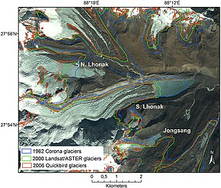
South Lhonak Lake is a glacial-moraine-dammed lake, located in Sikkim's far northwestern region. It is one of the fastest expanding lakes in the Sikkim Himalaya region, and one of the 14 potentially dangerous lakes susceptible to Glacial lake outburst flood (GLOFs).

Atmospheric correction for Interferometric Synthetic ApertureRadar (InSAR) technique is a set of different methods to remove artefact displacement from an interferogram caused by the effect of weather variables such as humidity, temperature, and pressure. An interferogram is generated by processing two synthetic-aperture radar images before and after a geophysical event like an earthquake. Corrections for atmospheric variations are an important stage of InSAR data processing in many study areas to measure surface displacement because relative humidity differences of 20% can cause inaccuracies of 10–14 cm InSAR due to varying delays in the radar signal. Overall, atmospheric correction methods can be divided into two categories: a) Using Atmospheric Phase Screen (APS) statistical properties and b) Using auxiliary (external) data such as GPS measurements, multi-spectral observations, local meteorological models, and global atmospheric models.

References

  1. 1 2 3 "Faculty | Centre of Studies in Resources Engineering (CSRE), IIT Bombay".
  2. 1 2 3 "Y.S.Rao's Homepage". www.csre.iitb.ac.in. Retrieved 7 February 2019.
  3. "People-MRSLab".
  4. 1 2 3 4 5 "Yalamanchili Subrahmanyeswara Rao" (PDF).
  5. Raney, R.K. (Winter 2007). "Hybrid-Polarity SAR Architecture". IEEE Transactions on Geoscience and Remote Sensing. 45 (11): 3397–3404. Bibcode:2007ITGRS..45.3397R. doi:10.1109/tgrs.2007.895883. ISSN   0196-2892. S2CID   14851919.
  6. "Contacts and Acknowledgement | PolSARpro | ESA". earth.esa.int. Retrieved 7 February 2019.
  7. "Software Development for Polarimetric SAR Data Processing: PolSDP". ResearchGate. Retrieved 7 February 2019.
  8. "Yalamanchili S. Rao". ieeexplore.ieee.org. Retrieved 7 February 2019.
  9. Rae, K.S.; Raju, S.; Rao, Y.S. (1991). "Model for the Retrieval of Soil Moisture and Surface Roughness Parameters from Multifrequency Backscattering Coefficients". [Proceedings] IGARSS'91 Remote Sensing: Global Monitoring for Earth Management. Vol. 2. pp. 397–400. doi:10.1109/igarss.1991.579166. ISBN   978-0879426750. S2CID   62264358.
  10. Ijjas, G.; Rao, K.S.; Rao, Y.S. (1991). "Efficiency of 1.4 and 2.7 GHZ Radiometers Data for the Retrieval of Soil Moisture Profile". [Proceedings] IGARSS'91 Remote Sensing: Global Monitoring for Earth Management. Vol. 2. pp. 765–768. doi:10.1109/igarss.1991.579998. ISBN   978-0879426750. S2CID   62102635.
  11. IJJAS, G.; RAO, Y. S. (Winter 1992). "Passive microwave remote sensing of soil moisture from aircraft in Hungary". International Journal of Remote Sensing. 13 (3): 471–479. Bibcode:1992IJRS...13..471I. doi:10.1080/01431169208904050. ISSN   0143-1161.
  12. Rao, K. S.; Narasimha Rao, P. V.; Subrahmanyeswara Rao, Y.; Chandra, Girish; Suresh Raju, C.; Bapat, M. V. (Fall 1988). "A study on the effect of the soil texture on passive microwave remote sensing". Journal of the Indian Society of Remote Sensing. 16 (3): 55–63. doi:10.1007/bf02998739. ISSN   0255-660X. S2CID   129417213.
  13. Rao, Y.; Sharma, S.; Garg, V.; Venkataraman, G. (2006). "Soil Moisture Mapping over India using Aqua AMSR-E Derived Soil Moisutre Product". 2006 IEEE International Symposium on Geoscience and Remote Sensing. pp. 2999–3002. doi:10.1109/igarss.2006.770. ISBN   978-0780395107. S2CID   39047996.
  14. Rao, Y. S.; Sharma, Sonika (1 December 2006). Kogan, Felix; Habib, Shahid; Hegde, V. S; Matsuoka, Masashi (eds.). "Monitoring of flood over Gujarat region using AQUA AMSR-E derived surface soil moisture". Disaster Forewarning Diagnostic Methods and Management. SPIE. 6412: 641208. Bibcode:2006SPIE.6412E..08R. doi:10.1117/12.697525. S2CID   140672195.
  15. Kumar, Vineet; Mandal, Dipankar; Rao, Y. S.; Meadows, Peter (2017). "Hybrid and dual linear polarimetric RISAT-1 SAR data for classification assessment". 2017 IEEE International Geoscience and Remote Sensing Symposium (IGARSS). pp. 1028–1031. doi:10.1109/igarss.2017.8127130. ISBN   9781509049516. S2CID   31775525.
  16. Turkar, Varsha; De, Shaunak; Rao, Y. S.; Shitole, Sanjay; Bhattacharya, Avik; Das, Anup (2013). "Comparative analysis of classification accuracy for RISAT-1 compact polarimetric data for various land-covers". 2013 IEEE International Geoscience and Remote Sensing Symposium - IGARSS. pp. 3586–3589. doi:10.1109/igarss.2013.6723605. ISBN   9781479911141. S2CID   39185190.
  17. Rao, Y. S.; Venkataraman, G.; Singh, G. (1 December 2006). Valinia, Azita; Uratsuka, Seiho; Misra, Tapan (eds.). "ENVISAT-ASAR data analysis for snow cover mapping over Gangotri region". Microwave Remote Sensing of the Atmosphere and Environment V. SPIE. 6410: 641007. Bibcode:2006SPIE.6410E..07R. doi:10.1117/12.693845. S2CID   129109511.
  18. Kumar, V.; Rao, Y.; Venkataraman, G.; Sarwade, R.; Snehmani (2006). "Analysis of Aqua AMSR-E Derived Snow Water Equivalent over Himalayan Snow Covered Regions". 2006 IEEE International Symposium on Geoscience and Remote Sensing. pp. 702–705. doi:10.1109/igarss.2006.184. ISBN   978-0780395107. S2CID   1583994.
  19. y.s. Rao, G. Venkataraman (2004). "SAR interferometry for DEM generation and movemnet of Indian glaciers". IEEE International IEEE International IEEE International Geoscience and Remote Sensing Symposium, 2004. IGARSS '04. Proceedings. 2004. Vol. 2. pp. 1128–1131. doi:10.1109/igarss.2004.1368612. ISBN   978-0780387423. S2CID   30338062.
  20. Rao, Y. S. (2011), "Synthetic Aperture Radar (SAR) Interferometry for Glacier Movement Studies", Encyclopedia of Snow, Ice and Glaciers, Encyclopedia of Earth Sciences Series, Springer Netherlands, pp. 1133–1142, doi:10.1007/978-90-481-2642-2_618, ISBN   9789048126415
  21. Kumar, Vineet; McNairn, Heather; Bhattacharya, Avik; Rao, Yalamanchili Subrahmanyeswara (2017). "Temporal Response of Scattering From Crops for Transmitted Ellipticity Variation in Simulated Compact-Pol SAR Data". IEEE Journal of Selected Topics in Applied Earth Observations and Remote Sensing. 10 (12): 5163–5174. Bibcode:2017IJSTA..10.5163K. doi:10.1109/jstars.2017.2757041. ISSN   1939-1404. S2CID   35935745.
  22. Mandal, Dipankar; Kumar, Vineet; Bhattacharya, Avik; Rao, Yalamanchili Subrahmanyeswara; Siqueira, Paul; Bera, Soumen (2018). "Sen4Rice: A Processing Chain for Differentiating Early and Late Transplanted Rice Using Time-Series Sentinel-1 SAR Data With Google Earth Engine". IEEE Geoscience and Remote Sensing Letters. 15 (12): 1947–1951. Bibcode:2018IGRSL..15.1947M. doi:10.1109/lgrs.2018.2865816. ISSN   1545-598X. S2CID   56172393.
  23. 1 2 Ponnurangam, G. G.; Jagdhuber, Thomas; Hajnsek, Irena; Rao, Y. S. (2016). "Soil Moisture Estimation Using Hybrid Polarimetric SAR Data of RISAT-1". IEEE Transactions on Geoscience and Remote Sensing. 54 (4): 2033–2049. Bibcode:2016ITGRS..54.2033P. doi:10.1109/tgrs.2015.2494860. ISSN   0196-2892. S2CID   7932702.
  24. Ponnurangam, G. G.; Rao, Y. S. (22 May 2017). "Evaluation of different orientation angle distributions within the X-Bragg scattering model for bare soil moisture estimation". International Journal of Remote Sensing. 38 (15): 4379–4395. Bibcode:2017IJRS...38.4379P. doi:10.1080/01431161.2017.1320447. ISSN   0143-1161. S2CID   134834334.
  25. Mandal, Dipankar; Kumar, Vineet; Bhattacharya, A.; Rao, Y. S.; McNairn, Heather (2018). "Crop Biophysical Parameters Estimation with a Multi-Target Inversion Scheme using the Sentinel-1 SAR Data". IGARSS 2018 - 2018 IEEE International Geoscience and Remote Sensing Symposium. pp. 6611–6614. doi:10.1109/igarss.2018.8518700. ISBN   9781538671504. S2CID   53231047.
  26. Deo, Rinki; Rossi, Cristian; Eineder, Michael; Fritz, Thomas; Rao, Y. S. (2015). "Framework for Fusion of Ascending and Descending Pass TanDEM-X Raw DEMs" (PDF). IEEE Journal of Selected Topics in Applied Earth Observations and Remote Sensing. 8 (7): 3347–3355. Bibcode:2015IJSTA...8.3347D. doi:10.1109/jstars.2015.2431433. ISSN   1939-1404. S2CID   35278122.
  27. Rao, Y. S.; Deo, R.; Nalini, J.; Pillai, A. M.; Muralikrishnan, S.; Dadhwal, V. K. (27 November 2014). "Quality assessment of TanDEM-X DEMs using airborne LiDAR, photogrammetry and ICESat elevation data". ISPRS Annals of the Photogrammetry, Remote Sensing and Spatial Information Sciences. II-8: 187–192. Bibcode:2014ISPAn.II8..187R. doi: 10.5194/isprsannals-ii-8-187-2014 . ISSN   2194-9050.
  28. Vaka, Divya Sekhar; Rao, Y. S. (2018). "Deformation of Bhuj Earthquake Area Obtained with Persistent Scatterer Interferometric Analysis of Alos L-Band Sar Data". IGARSS 2018 - 2018 IEEE International Geoscience and Remote Sensing Symposium. pp. 513–516. doi:10.1109/igarss.2018.8519072. ISBN   9781538671504. S2CID   53231271.