The Cambrian Mountains are a series of mountain ranges in Wales. The term Cambrian Mountains used to apply to most of the upland of Wales. Since the 1950s, its application has become increasingly localised to the geographically homogeneous Mid Wales uplands, known in Welsh as Elenydd, which extend from Pumlumon to Radnor Forest in the east and Mynydd Mallaen to the south. This barren and sparsely populated 'wilderness' has been referred to as the Desert of Wales. The area includes the sources of the River Severn and River Wye and was unsuccessfully proposed as a national park in the 1960s and 1970s. The highest point of the range is Plynlimon, at 2,467 feet (752 m).

Elidir Fawr is a mountain in Snowdonia, north Wales, the northernmost peak in the Glyderau.

Moel Hebog is a mountain in Snowdonia, north Wales which dominates the view west from the village of Beddgelert. It gives name to a whole range of peaks in the north-western corner of Snowdonia, which include the Nantlle Ridge and Mynydd Mawr.
Y Garn is a mountain in Snowdonia, North Wales, part of the Glyderau.

Yr Eifl, sometimes called the Rivals in English, is a group of hills on the north coast of the Llŷn Peninsula in Gwynedd, Wales.
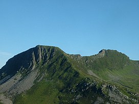
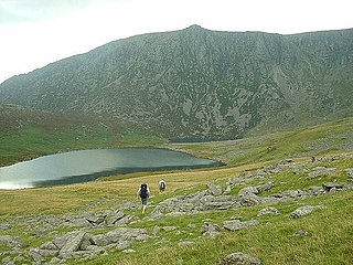
Carnedd Dafydd is a mountain peak in the Carneddau range in Snowdonia, North Wales, and is the third highest peak in Wales, or the fourth if Crib y Ddysgl on the Snowdon ridge is counted. Situated south-west of Carnedd Llewelyn and north of Pen yr Ole Wen, Carnedd Dafydd is on the main ridge of the Carneddau, and on the border between Gwynedd and Conwy. The average annual temperature of the mountain is around 3–4 °C.

Blorenge, also called The Blorenge, is a prominent hill overlooking the valley of the River Usk near Abergavenny, Monmouthshire, southeast Wales. It is situated in the southeastern corner of the Brecon Beacons National Park. The summit plateau reaches a height of 1,841 feet (561 m).

Foel-fras (944 m) is a mountain in the Carneddau range, about 10 km east of Bethesda in North Wales. It lies on the border between the counties of Gwynedd and Conwy. With a summit elevation of 944 m it is officially the eleventh-highest summit in Wales. Foel-fras is located at the northern end of the main ridge of the Carneddau, between Drum to the north and Foel Grach to the south, with the subsidiary summit of Garnedd Uchaf (925 m) between it and Foel Grach. Due south and 400 m below lies the reservoir of Llyn Dulyn, while the smaller reservoir of Llyn Anafon lies to the north.
For other hills of the same name, see Y Garn (disambiguation).

Diffwys is a mountain in Snowdonia, Wales, near Barmouth and forms part of the Rhinogydd. On the north side is an exposure of the Caerdion Syncline. It is technically a subsidiary summit of Y Llethr, missing Marilyn status by 2m. It is therefore like Rhinog Fach a sub Marilyn.

Drygarn Fawr is a mountain in the county of Powys, Wales. It is one of the highest summits in Mid Wales standing at 645 metres or 2114 feet above sea level. It lies to the south of the Elan Valley Reservoirs. Rising above the remote moorland plateau of the Cambrian Mountains, and to the west of the peaks of Radnor Forest, the summit is topped by two distinctive, large cairns. The mountain has a gentle, grassy, conical shape with a few rocks near the summit. Nearby are the summits of Gorllwyn, Y Gamriw, and Drum yr Eira all over 600m.
Craig Cwm Silyn is a mountain in Snowdonia, North Wales which forms the highest point on the celebrated Nantlle Ridge.
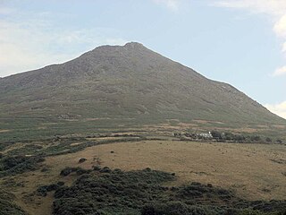
Carn Fadryn, sometimes Carn Fadrun or Garn Fadryn, is a five-hectare Iron Age hillfort and is the name of the mountain on which the fort is situated. It lies in the centre of the Llŷn Peninsula, Gwynedd, and overlooks the village of Garnfadryn, Wales.
Pen Pumlumon Arwystli is the second highest summit on the Plynlimon massif, a part of the Cambrian Mountains in the county of Ceredigion, Wales.

Corn Du is a summit of the twin topped Pen y Fan and the second highest peak in South Wales at 873 m (2,864 ft), situated in the Brecon Beacons National Park. The summit itself is marked by a well structured Bronze Age cairn with a central burial cist like that on nearby Pen y Fan. The two summits are visible from great distances owing to their height above the surrounding moorland, and are famous landmarks. The views from the peaks are also panoramic and very extensive, the Black Mountain and Fforest Fawr being especially obvious to the west. Mynydd Epynt is visible to the north behind the county town of Brecon, and other parts of the escarpment to the east.

Gau Graig is a subsidiary summit of Cadair Idris in the Snowdonia National Park, in Gwynedd, northwest Wales. It lies to the east of Mynydd Moel on a broad grassy plateau. It marks the eastern end of the Cadair Idris ridge.

Pen y Castell is a summit in the Carneddau mountains in north Wales. It tops the east ridge of Drum (Wales). The summit consists of rocky outcrops amid a small boggy plateau. Views of the higher Carneddau ridge to the west, Craig Eigiau to the south, Tal y Fan to the north and the Conwy valley to the east can be seen.

Carnedd y Filiast is a mountain in Snowdonia, Wales, forming part of the Glyderau. It, along with its top Y Fronllwyd, forms the most northerly summit in the Glyderau. The average annual temperature on Carnedd y Filiast is estimated to be around 4 Celsius.
Pen y Garn is a mountain in the Cambrian Mountains, Mid Wales standing at 611 metres above sea level.

Mynydd y Garn is a hill in the northwest of the Isle of Anglesey in north Wales. Its 170 m (560 ft) high summit is crowned by a trig point and a stone obelisk. Erected in 1897 it commemorates Sir William Thomas, ship-owner and one time High Sheriff of Anglesey.