Yamasá

Last updated • 1 min readFrom Wikipedia, The Free Encyclopedia
Yamasá
Dominican Republic relief location map.jpg
Red pog.svg
Yamasá
Coordinates: 18°46′N70°01′W / 18.767°N 70.017°W / 18.767; -70.017 Coordinates: 18°46′N70°01′W / 18.767°N 70.017°W / 18.767; -70.017
CountryFlag of the Dominican Republic.svg  Dominican Republic
Province Monte Plata
Area
[1]
  Total441.61 km2 (170.51 sq mi)
Elevation
[2]
82 m (269 ft)
Population
 (2012)
  Total57,982
  Density130/km2 (340/sq mi)
Municipal Districts 1
Distance to
 Santo Domingo

42 km (26 mi)

Yamasá is a municipality ( municipio ) of the Monte Plata province in the Dominican Republic. It includes the municipal district (distrito municipal) of Los Botados. [3] Yamasa is north of the capital city of Santo Domingo. The Rio Ozama, one of Dominican Republic's longest rivers, passes through Yamasa.

Contents

Climate

Climate data for Yamasá (1961–1990)
MonthJanFebMarAprMayJunJulAugSepOctNovDecYear
Record high °C (°F)35.0
(95.0)
37.7
(99.9)
36.7
(98.1)
37.9
(100.2)
38.7
(101.7)
39.6
(103.3)
39.4
(102.9)
38.4
(101.1)
38.4
(101.1)
38.8
(101.8)
37.0
(98.6)
34.6
(94.3)
39.6
(103.3)
Average high °C (°F)29.5
(85.1)
30.3
(86.5)
31.2
(88.2)
32.0
(89.6)
32.6
(90.7)
33.1
(91.6)
33.2
(91.8)
32.9
(91.2)
32.8
(91.0)
32.5
(90.5)
31.1
(88.0)
29.9
(85.8)
31.8
(89.2)
Average low °C (°F)18.9
(66.0)
19.0
(66.2)
19.7
(67.5)
20.2
(68.4)
20.9
(69.6)
21.3
(70.3)
21.5
(70.7)
21.3
(70.3)
21.1
(70.0)
20.8
(69.4)
20.2
(68.4)
19.2
(66.6)
20.3
(68.5)
Record low °C (°F)13.2
(55.8)
13.7
(56.7)
13.5
(56.3)
13.5
(56.3)
15.5
(59.9)
16.2
(61.2)
16.3
(61.3)
15.7
(60.3)
15.5
(59.9)
15.3
(59.5)
13.8
(56.8)
10.6
(51.1)
10.6
(51.1)
Average rainfall mm (inches)90.0
(3.54)
95.1
(3.74)
101.7
(4.00)
161.6
(6.36)
287.4
(11.31)
246.9
(9.72)
255.6
(10.06)
326.6
(12.86)
250.7
(9.87)
245.3
(9.66)
161.4
(6.35)
121.8
(4.80)
2,344.1
(92.29)
Average rainy days (≥ 1.0 mm)9.68.07.38.915.014.016.517.715.214.712.110.6149.6
Source: NOAA [4]

Farming

Primarily a rural agriculture community, sugar cane, plantains and mangoes are common staples grown in Yamasa.

Famous citizens

Related Research Articles

San Cristóbal Province Province of the Dominican Republic

San Cristóbal is a province in the southern Dominican Republic, west of the capital Santo Domingo. It was originally named Trujillo after the dictator Rafael Leónidas Trujillo, taking its present name after his assassination in 1961. It included what is now Monte Plata Province until 1992. The provincial capital is San Cristóbal. In 2007, a documentary was filmed near Hato Damas, about a group of coffee and cacao producers who work together, called Convite. It is available on YouTube.

Provinces of the Dominican Republic

The Dominican Republic is divided into thirty–one provincias, while the national capital, Santo Domingo, is contained within its own Distrito Nacional.

Barahona Province province of the Dominican Republic

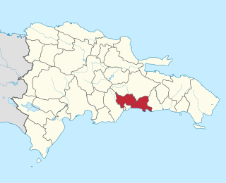
Barahona is a province of the Dominican Republic. The Barahona Coast is located on the southwestern part of the Dominican Republic approximately three hours drive from Santo Domingo the capital of the Dominican Republic. In 2019, volunteers from Amigos de las Americas visited to facilitate projects within the various municipalities of Barahona.

La Romana Province, Dominican Republic Province of the Dominican Republic

La Romana is a province of the Dominican Republic. The capital is also named La Romana, and is the third-largest city in the country. La Romana was elevated to the category of province in 1944.

Monseñor Nouel Province Province of the Dominican Republic

Monseñor Nouel is a province of the Dominican Republic. It was split from La Vega in 1982.

Monte Plata Province Province of the Dominican Republic

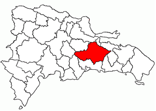
Monte Plata is a province of the Dominican Republic, and also the name of its capital city. It was split from San Cristóbal in 1992.

Samaná Province Province of the Dominican Republic

Samaná is a province of the Dominican Republic in the Samaná Peninsula. Its capital is Santa Bárbara de Samaná, usually known as Samaná.

Santo Domingo Province Province of the Dominican Republic

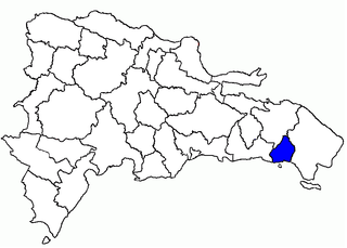
Santo Domingo is a province of the Dominican Republic. It was split from the Distrito Nacional on October 16, 2001.

Boca Chica municipality in Santo Domingo, Dominican Republic

Boca Chica is a municipality (municipio) of the Santo Domingo province in the Dominican Republic. Within the municipality there is one municipal district : La Caleta. As of the 2012 census it had 123,510 inhabitants, 70,184 living in the city itself and 53,326 in its rural districts (Secciones).

Bayaguana Municipality in Monte Plata, Dominican Republic

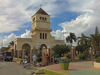
Bayaguana is a municipality (municipio) of the Monte Plata province in the Dominican Republic.

Monte Plata Municipality in Dominican Republic

Monte Plata is a municipality (municipio) and the capital of the Monte Plata province in the Dominican Republic. It includes the municipal districts of Boyá, Chirino, and Don Juan.

Santo Domingo Este Municipality in Santo Domingo, Dominican Republic

Santo Domingo Este is a municipality and the provincial capital of the Santo Domingo province in the Dominican Republic. It has one municipal district, San Luis.

Santo Domingo Norte Place in Santo Domingo, Dominican Republic

Santo Domingo Norte is a municipality of the Santo Domingo Province in the Dominican Republic. There is one municipal district within the municipality: La Victoria.

Santo Domingo Oeste Place in Santo Domingo, Dominican Republic

Santo Domingo Oeste is a municipality of the Santo Domingo province in the Dominican Republic. It is part of the greater Santo Domingo metropolitan area, which is the de facto co-capital of the Dominican Republic as seat of the Constitutional Court and the Central Electoral Commission.

Los Alcarrizos is a municipality (municipio) of the Santo Domingo province in the Dominican Republic. Within the municipality there are the following municipal districts : Palmarejo-Villa Linda and Pantoja.

Pedro Brand Place in Santo Domingo, Dominican Republic

Pedro Brand is a municipality (municipio) of the Santo Domingo province in the Dominican Republic. Within the municipality there are two municipal districts : La Cuaba and La Guáyiga.

San Antonio de Guerra Place in Santo Domingo, Dominican Republic

San Antonio de Guerra is a municipality (municipio) of the Santo Domingo province in the Dominican Republic. Within the municipality there is one municipal district : Hato Viejo.

San Luis, Dominican Republic Place in Santo Domingo, Dominican Republic

San Luis is a municipality (municipio) of the Santo Domingo province in the Dominican Republic. The District Municipality became a municipality on September 30, 2011.

References

  1. Superficies a nivel de municipios, Oficina Nacional de Estadistica
  2. De la Fuente, Santiago (1976). Geografía Dominicana (in Spanish). Santo Domingo, Dominican Republic: Editora Colegial Quisqueyana.
  3. "Listado de Codigos de Provincias, Municipio y Distritos Municipales, Actualizada a Junio 20 del 2006" (in Spanish). Departamento de Cartografia, Division de Limites y Linderos. 20 June 2006. Archived from the original on 14 March 2007. Retrieved 12 August 2011.
  4. "Yamasa Climate Normals 1961-1990". National Oceanic and Atmospheric Administration. Retrieved September 21, 2016.