Yanshui River

Last updated
Yanshui River

Taijiang National Park from Anping.JPG

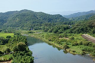
Yanshui River seen from Anping, with the Taijiang National Park on the other side.
Taiwan relief location map.jpg
Red pog.svg
Yanshui River in Taiwan
Country Taiwan
Physical characteristics
River mouth Taiwan Strait: Anping District/Annan District
23°00′14″N120°09′00″E / 23.004°N 120.15°E / 23.004; 120.15 Coordinates: 23°00′14″N120°09′00″E / 23.004°N 120.15°E / 23.004; 120.15
Length 41 km (25 mi)
Basin features
Basin size 343 km2 (132 sq mi)
Landmarks Taijiang National Park

The Yanshui River (Chinese :鹽水溪; Hanyu Pinyin :Yánshuǐ Xī; Tongyong Pinyin :Yánshuěi Si; Pe̍h-ōe-jī :Kiâm-chuí-khe) is a river in southern Taiwan. It flows through Tainan City for about 41.3 km. [1] [2] The wetlands at the river mouth fall partly in the Taijiang National Park. [3]

Traditional Chinese characters

Traditional Chinese characters are Chinese characters in any character set that does not contain newly created characters or character substitutions performed after 1946. They are most commonly the characters in the standardized character sets of Taiwan, of Hong Kong and Macau, and in the Kangxi Dictionary. The modern shapes of traditional Chinese characters first appeared with the emergence of the clerical script during the Han Dynasty, and have been more or less stable since the 5th century.

Hanyu Pinyin, often abbreviated to pinyin, is the official romanization system for Standard Chinese in mainland China and to some extent in Taiwan. It is often used to teach Standard Mandarin Chinese, which is normally written using Chinese characters. The system includes four diacritics denoting tones. Pinyin without tone marks is used to spell Chinese names and words in languages written with the Latin alphabet, and also in certain computer input methods to enter Chinese characters.

Tongyong Pinyin was the official romanization of Mandarin Chinese in Taiwan between 2002 and 2008. The system was unofficially used between 2000 and 2002, when a new romanization system for Taiwan was being evaluated for adoption. Taiwan's Ministry of Education approved the system in 2002, but its use was optional. Since January 1, 2009, Tongyong Pinyin has no longer been official because of the Ministry of Education's approval of Hanyu Pinyin on September 16, 2008.

See also

Related Research Articles

Annan District District

Annan District (Chinese: 安南區; pinyin: Ānnán Qū; Wade–Giles: An1-Nan2 Ch'ü1; Pe̍h-ōe-jī: An-Lâm-Khu) is a coastal district located in the west of Tainan, Taiwan. It was the largest district in Tainan City before the city was enlarged in 2010.

Shuang River river in Taiwan

The Shuang River is a river in Taiwan. It flows through the eponymous Shuangxi District and Gongliao District in eastern New Taipei City for 27 km. Fulong Beach, one of the more popular beach destinations in northern Taiwan, is located at the mouth of the Shuang River.

Fengshan River river in Taiwan

The Fengshan River is a river in northern Taiwan. It flows through Hsinchu County for 45 km.

Touqian River river in Taiwan

The Touqian River is a river in northern Taiwan. It flows through Hsinchu County for 63 km.

Houlong River river in Taiwan

The Houlong River is a river in northwestern Taiwan. It flows through Miaoli County for 58 kilometers.

Dadu River (Taiwan) river in Taiwan

The Wu River (Chinese: 烏溪; Pe̍h-ōe-jī: O͘-khe), also known as the Dadu River (Chinese: 大肚溪; pinyin: Dàdù Xī; Wade–Giles: Ta4-tu4 Hsi1) is a river in Taiwan. It flows through Taichung City, Changhua County, and Nantou County for 119 kilometers. It is the fourth largest river in Taiwan in terms of drainage area, and the sixth longest one.

Beigang River river in Taiwan

The Beigang River is a river in Taiwan. It flows through Yunlin and Chiayi counties for 82 km.

Jishui River river in Taiwan

The Jishui River is a river in Taiwan. It flows through Tainan City for 65 km.

Zengwen River river in Taiwan

The Zengwen River is a river in Taiwan. It flows through Tainan and Chiayi County for 138 km.

Qishan River river in Taiwan

The Qishan River or Nanzixian River is a tributary of the Gaoping River in Taiwan. It flows through Chiayi County, Kaohsiung City, and Pingtung County for 117 km.

Wuluo River river in Taiwan

The Wuluo River, also spelled Wulo River, (Chinese: 武洛溪; pinyin: Wǔluò Xī; Wade–Giles: Wu3-lo4 Hsi1) is a tributary of the Gaoping River in Pingtung County, Taiwan.

Donggang River (Taiwan) river in Taiwan

The Donggang River is a river in Taiwan. It flows through Pingtung County for 44 km.

Xiuguluan River river in Taiwan

The Xiuguluan River is a river in southeastern Taiwan. It flows through the Huatung Valley for 81 km (50 mi) before emptying into the Pacific Ocean in Fengbin, Hualien.

Hualian River river in Taiwan

The Hualian River, also spelled Hualien River, is a river in Taiwan. It flows through Hualien County for 57 kilometres (35 mi). The Haian Range starts at the mouth of the river.

The Taiwan Lantern Festival is an annual event hosted by the Tourism Bureau of the Ministry of Transportation and Communications in Taiwan to celebrate the Lantern Festival.

Sicao Wetlands protected ecological environment in Tainan, Taiwan

The Sihcao Wetlands are wetlands in Tainan, Taiwan. They were set aside in 1994 by the Tainan City Government and consist of approximately 515 hectares.

Taijiang National Park A national park in Tainan

Taijiang National Park is a national park in Tainan, Taiwan.

Xiangshan District, Hsinchu District in Hsinchu City, Taiwan

Xiangshan District or Siangshan District is a district in southwest Hsinchu City, Taiwan. It is the largest of the three districts in Hsinchu City.

Mataian Wetland Ecological Park A wetland in Hualien County

The Matai'an Wetland Ecological Park is a wetland in Guangfu Township, Hualien County, Taiwan.

Linyuan Ocean Wetland Park is a wetland in Linyuan District, Kaohsiung, Taiwan.

References

  1. "Geography & demographics". The Republic of China Yearbook 2015. Executive Yuan. 2015. pp. 40–53. ISBN   978-986-04-6013-1.
  2. "GeoNames Search". Geographic Names Database. National Geospatial-Intelligence Agency, USA. Retrieved 1 May 2016.
  3. "Yanshui River mouth wetlands". Taijiang National Park: Visitor Information. Taijiang National Park. Retrieved 1 May 2016.