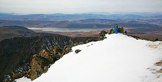
The geography of Tibet consists of the high mountains, lakes and rivers lying between Central, East and South Asia. Traditionally, Western sources have regarded Tibet as being in Central Asia, though today's maps show a trend toward considering all of modern China, including Tibet, to be part of East Asia. Tibet is often called "the roof of the world," comprising tablelands averaging over 4,950 metres above the sea with peaks at 6,000 to 7,500 m, including Mount Everest, on the border with Nepal.

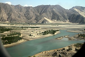
The Yarlung Tsangpo, also called Yarlung Zangbo and Yalu Zangbu River is the upper stream of the Brahmaputra River located in the Tibet Autonomous Region, China. It is the longest river of Tibet and the fifth longest in China. The upper section is also called Dangque Zangbu meaning "Horse River."
The Northeastern Himalayan subalpine conifer forests are a temperate coniferous forests ecoregion of the middle to upper elevations of the eastern Himalayas and southeast Tibetan Plateau. The ecoregion occurs in southeastern Tibet Autonomous Region, China, in northern and eastern Arunachal Pradesh, India, and extreme eastern Bhutan.
The Transbaikal conifer forests ecoregion covers a 1,000 km by 1,000 km region of mountainous southern taiga stretching east and south from the shores of Lake Baikal in the Southern Siberia region of Russia, and including part of northern Mongolia. Historically, the area has been called "Dauria", or Transbaikal. It is in the Palearctic realm, and mostly in the boreal forests/taiga biome with a subarctic, humid climate. It covers 200,465 km2 (77,400 sq mi).

The Southeast Tibet shrub and meadows are a montane grassland ecoregion that cover the southeast and eastern parts of the Tibetan Plateau in China. The meadows in this region of Tibet are in the path of the monsoon rains and are wetter than the other upland areas of the Tibetan Plateau. The "high cold" alpine terrain is one of high species diversity, due to the relatively high levels of precipitation for the region. Precipitation is lower in the northwest, and hence the vegetation thins from shrub to meadow or even desert.

The Altai montane forest and forest steppe ecoregion covers patches of the subalpine forest belt on the Altai Mountains, crossing the border region where Russia, Kazakhstan, Mongolia and China meet. The region has high biodiversity, as it is located in transition zones between different ecoregions, altitudes, and climate zones. It is in the Palearctic realm, with a Cold semi-arid climate. It covers 35,199,998 km2 (13,590,795 sq mi).

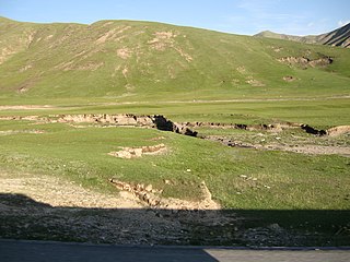
The Daurian forest steppe ecoregion is a band of grassland, shrub terrain, and mixed forests in northeast Mongolia and the region of Siberia, Russia that follows the course of the Onon River and Ulz River, and part of the northwestern China. The region has been described as a "sea of grass that forms the best and most intact example of an undisturbed steppe ecosystem and is also one of the last areas in the Palearctic that still supports stable herds of larger vertebrates" in a semi-mountainous area. The area also has flat wetlands that are important to migratory birds. The ecoregion is in the Palearctic realm, with a dry-winter subarctic climate that borders on a very cold semi-arid climate (BSk) in its southwestern parts. It covers 209,012 km2 (80,700 sq mi).

The Sayan intermontane steppe ecoregion is sometimes referred to as a "steppe island", being an expanse of grassland and shrubs surrounded by mountain forests in the Tyva Republic of south central Siberia, Russia. The Altai Mountains are to the west, the Sayan Mountains to the north, and the Tannu-Ola Mountains to the south. The ecoregion is in the temperate grasslands, savannas, and shrublands biome, and the Palearctic realm, with a Humid Continental climate. For much of its length, it follows the course of the upper Yenisei River. It covers 33,928 km2 (13,100 sq mi).

The Selenge–Orkhon forest steppe ecoregion stretches across north central Mongolia, and follows the Selenga River northeast into Russia. The ecoregion is itself at high elevations, but surrounded by higher mountain ranges. As a transition zone between taiga and steppe, it features conifer forests on the north slopes of mountains, and pine/aspen stands on southern slopes. It has an area of 227,660 square kilometres (87,900 sq mi).

The Helanshan montane conifer forests ecoregion covers an isolated, forested mountain range surrounded by desert and semi-arid basins. As such, it has been called a "mountain island in the sky", and supports endemic species of plants and animals. The region supports the endangered Helan Shan pika.

The Tian Shan montane steppe and meadows ecoregion covers a 2,000 km long stretch of grasslands of the isolated Tian Shan mountains of Central Asia. It is characterized by high-altitude flat and rolling grasslands.

The Tian Shan foothill arid steppe ecoregion covers the northern and western approaches to the Tian Shan mountains, centered on Lake Issyk-Kul in Kyrgyzstan. This region receives more moisture from Central Asia, thereby supporting more vegetation and diversity of plant and animal species than the deserts to the south.

The Pamir alpine desert and tundra ecoregion covers the high plateau of the Pamir Mountains, at the central meeting of the great mountain ranges of Central Asia: Himalaya, Karakoram, Hindu Kush, Kunlun, and Tian Shan. It is a region of relatively high biodiversity due to its central location and high elevation differentials, but it also acts as a barrier between the climate and habitats of north and south Asia.
The Central Tibetan Plateau alpine steppe ecoregion covers the high alpine plateau that stretches over 1,600 kilometres (1,000 mi) across the Tibetan Plateau to Qinghai Lake in China. Because of the high altitude—much it over 5,000 metres (16,000 ft)—the region is a cold, arid desert that is only 20% covered with steppe and meadow vegetation. The area has been relatively free from human development due to the hostile climate and unsuitability for agriculture. The ecosystem is relatively intact, and supports herds of wild antelope, sheep, deer, and gazelles.

The North Tibetan Plateau-Kunlun Mountains alpine desert ecoregion covers a long stretch of mostly treeless alpine terrain across the northern edge of the Tibet Plateau. A variety of cold, dry habitats are found, including alpine meadows, steppe, desert, and cushion plant floral areas.

The Tibetan Plateau alpine shrublands and meadows ecoregion covers the middle transition zone between the northern and southern regions of the Tibetan Plateau. The region supports both cold alpine steppe and meadows across a broad expanse of the plateau. Wild deer, antelope, and sheep roam the grasslands, but the habitat is increasingly being used to graze domestic livestock.
The Khangai Mountains alpine meadows ecoregion runs along the central ridge of the Khangai Mountains in central Mongolia. The slopes to the north are conifer forests, the lowlands to the south are semi-arid steppe. The Khangai are an "island" mountain range surrounded by lower forest steppe and semi-arid regions of central Mongolia. Most of the region is now protected by Tarvagatai Nuruu National Park and Khangai Nuruu National Park.

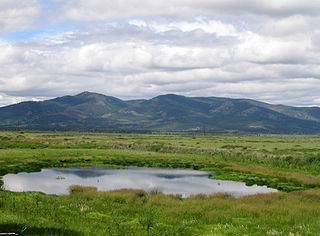
The Gobi Lakes Valley desert steppe ecoregion covers the narrow, flat valley in southwestern Mongolia that lies between the Khangai Mountains, and the Gobi-Altai Mountains. The region is known as the "Valley of the Lakes" because runoff from the mountains collect in lakes that have no outlet to the sea. Although the valley is a semi-arid desert steppe, it has areas of wetlands near the lakes that are important habit for water birds.

The Central Asian southern desert ecoregion is an arid but ecologically active region between the east coast of the Caspian Sea and steppes at the base of the mountains of central Asia. Most of Turkmenistan and eastern Uzbekistan is in this ecoregion. The winters are milder than in the cold desert to the north, and a large number of endemic species have adapted to living in the particular climate and soil of the region. As with sandy deserts in general, the region is notable for high numbers of endemic species of reptiles and insects.
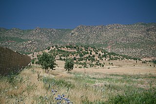
The Middle East steppe ecoregion stretches in an arc from southern Jordan across Syria and Iraq to the western border of Iran. The upper plains of the Tigris and Euphrates Rivers dominate most of the ecoregion. The terrain is mostly open shrub steppe. The climate is arid. Evidence is that this region was once more of a forest-steppe, but centuries of overgrazing and gathering firewood have reduced tree and grass cover to small areas and along the riverine corridors. Despite the degraded condition of the steppe environment, the ecoregion is important for water birds as the rivers and reservoirs provide habitat in the arid region.