
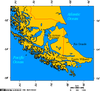
Tierra del Fuego is an archipelago off the southernmost tip of the South American mainland, across the Strait of Magellan. The archipelago consists of the main island, Isla Grande de Tierra del Fuego, with an area of 48,100 km2 (18,572 sq mi), and a group of many islands, including Cape Horn and Diego Ramírez Islands. Tierra del Fuego is divided between Chile and Argentina, with the latter controlling the eastern half of the main island and the former the western half plus the islands south of Beagle Channel. The southernmost extent of the archipelago is at about latitude 55°S.

Tierra del Fuego is the southernmost, smallest, and least populous Argentine province.

Isla Grande de Tierra del Fuego also formerly Isla de Xátiva is an island near the southern tip of South America from which it is separated by the Strait of Magellan. The western portion (61.4%) of the island is in Chile, while the eastern portion is in Argentina. It forms the major landmass in an extended group of islands or archipelago also known as Tierra del Fuego.
Southernmost settlements are cities, towns, weather stations or permanent military bases which are farther south than latitude 45°S. They are closely related to the Southern Ocean or either the Roaring Forties or Furious Fifties. Antarctic bases are excluded due to not having a permanent population.
Puerto Williams is the city, port and naval base on Navarino Island in Chile. It faces the Beagle Channel. It is the capital of the Chilean Antarctic Province, one of four provinces in the Magellan and Chilean Antarctica Region, and administers the communes of Chilean Antarctic Territory and Cabo de Hornos. It has a population of 2,874, including both naval personnel and civilians. Puerto Williams claims the title of world's southernmost city. The settlement was founded in 1953, and was first named Puerto Luisa. The town was later named after John Williams Wilson, a British man who founded Fuerte Bulnes, the first settlement in the Strait of Magellan since 1587. It has served primarily as a naval base for Chile. The Chilean Navy runs the Guardiamarina Zañartu Airport and hospital, as well as nearby meteorological stations. Since the late 20th century, the number of navy personnel has decreased in Puerto Williams and the civilian population has increased. In that period, tourism and support of scientific research have contributed to an increase in economic activity.

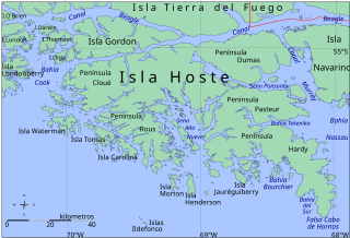
Beagle Channel is a strait in Tierra del Fuego Archipelago on the extreme southern tip of South America between Chile and Argentina. The channel separates the larger main island of Isla Grande de Tierra del Fuego from various smaller islands including the islands of Picton, Lennox and Nueva; Navarino; Hoste; Londonderry; and Stewart. The channel's eastern area forms part of the border between Chile and Argentina and the western area is entirely within Chile.

Picton, Lennox and Nueva form a group of three islands at the extreme southern tip of South America, in the Chilean commune of Cabo de Hornos in Antártica Chilena Province, Magallanes and Antártica Chilena Region. Located in the Tierra del Fuego archipelago, they lie east of Navarino Island and are separated from the Argentine part of Isla Grande in the north by the Beagle Channel. They have an area of 170.4 km2 (Lennox), 105.4 km2 (Picton), 120.0 km2 (Nueva).

False Cape Horn or Falso Cabo de Hornos is a headland at the south end of Hoste Island, 35 statute miles (56 km) northwest of Cape Horn, located at 55°43′37″S68°03′16″W. False Cape Horn is the southernmost point of the large islands of the Tierra del Fuego group, located close to the mainland of South America.

Navarino Island is a Chilean island located between Isla Grande de Tierra del Fuego, to the north, and Cape Horn, to the south. The island forms part of the Commune of Cabo de Hornos, the southernmost commune in Chile and in the world, belonging to Antártica Chilena Province in the XII Region of Magallanes and Chilean Antarctica. Its population is concentrated primarily in the communal capital, Puerto Williams, and in small settlements like Puerto Navarino, Río Guanaco and Puerto Toro. The highest point of the island is Pico Navarino at 1,195 m (3,921 ft). The island is a popular destination for fly-fishers.

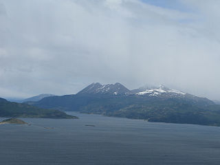
The Cordillera Darwin is an extensive mountain range mantled by an ice field that is located in Chile.
The Murray Channel is a channel of Chile located in the Commune of Cabo de Hornos, in the Antártica Chilena Province of the Magallanes y la Antártica Chilena Region. It separates Hoste Island from Navarino Island and is bounded by the Beagle Channel to the north. The salinity of the Murray Channel is approximately 31.8 parts per thousand.

The Chilean Antarctic Territory or Chilean Antarctica is the territory in Antarctica claimed by Chile. The Chilean Antarctic Territory ranges from 53° West to 90° West and from the South Pole to the 60° South parallel, partially overlapping the Argentine and British Antarctic claims. It is administered by the Cabo de Hornos municipality in the South American mainland.

The Azopardo River, is a river in Isla Grande de Tierra del Fuego, Chile at the southern tip of South America. It flows in a westerly direction and drains the waters of Fagnano Lake into Almirantazgo Fjord.

Bahia Wulaia is a bay on the western shore of Isla Navarino along the Murray Channel in extreme southern Chile. The island and adjacent strait are part of the commune of Cabo de Hornos in the Antártica Chilena Province, which is part of the Magallanes and Antartica Chilena Region.

The Yendegaia River originates from the terminus of Stoppani Glacier in Cordillera Darwin located at southwestern Isla Grande de Tierra del Fuego. Is part of Yendegaia National Park.

Tierra del Fuego National Park is a national park on the Argentine part of the island of Tierra del Fuego, within Tierra del Fuego Province in the ecoregion of Patagonic Forest and Altos Andes, a part of the subantarctic forest. Established on 15 October 1960 under the Law 15.554 and expanded in 1966, it was the first shoreline national park to be established in Argentina.
Bahía Cook, also known in English as Cook Bay, is an irregular bay located between Londonderry Island, Hoste Island, Olga Island and Gordon Island southwest of Tierra del Fuego in Chile.
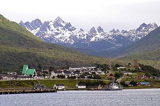
Yendegaia Airport Spanish: Aeropuerto Yendegaia, is a rural airstrip in the Magallanes Region of Chile. The nearest town is Ushuaia, 32 kilometres (20 mi) to the east in Argentina.

Yendegaia National Park is located in Tierra del Fuego in the Magallanes y la Antártica Chilena Region of Chile and contains 150,612 ha of mountainous terrain and Valdivian temperate rain forest. It borders the Alberto de Agostini National Park and Tierra del Fuego National Park.
