WFNO is a commercial AM radio station licensed to Gretna, Louisiana, and serving the New Orleans metropolitan area. The station is owned by Crocodile Broadcasting and airs a Spanish-language hot adult contemporary radio format.
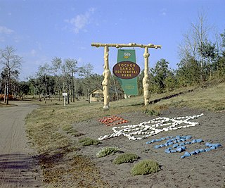
Rochon Sands Provincial Park is a provincial park located in Alberta, Canada. It is located on the south shore of Buffalo Lake, within the summer village of Rochon Sands. This provincial park can be accessed by traveling northeast from Red Deer on Highway 11, or northwest from Stettler on Highway 12 and secondary Highway 835. The park was established on January 8, 1957.

Bukkur Fort is an island located in Rohri, Sukkur District of Sindh province in Pakistan. Named Bukkur (Dawn) by Sayyid Muhammad Al-Makki in the seventh century of Hijri, this island is a limestone rock, oval in shape, 800 yards (730 m) long by 300 yards (270 m) wide, and about 25 feet (7.6 m) in height. According to the Superintendent of Land Records and Registration, Sindh, in 1912, the area of Bukkur island was 255,292 sq. yards, or 49 acres (20 ha). Nowadays Bukkur island is occupied by an Army Public School, and the tomb of Sayyid Sadruddin, who was the son of Sayyid Muhammad Al-Makki.

The Azopardo River, is a river in Isla Grande de Tierra del Fuego, Chile at the southern tip of South America. It flows in a westerly direction and drains the waters of Fagnano Lake into Almirantazgo Fjord.
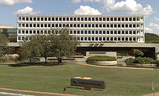
The Tribunal de Contas da União is the Brazilian federal audit office. It is tasked with assisting Congress in its Constitutional incumbency to exercise external audit over the Executive Branch. Its members, called ministers, are appointed by the National Congress and the President of Brazil. The TCU employs a highly qualified body of civil servants to prevent, investigate and sanction corruption and malpractice of public funds, with national jurisdiction.
The Little Canyon is a stretch of the Quesnel River in the Cariboo Country of the Central Interior of British Columbia, Canada, near the city of the same name.
Twin Poplars is an unincorporated community in Nelson County, Virginia, United States.

Sunset Falls is the final of the three waterfalls on the South Fork Skykomish River. The falls drop 104 feet (32 m) in a long, narrow, powerful chute. The river is thought to attain speeds of 60 kilometres (37 mi) an hour and the chute is nearly 300 feet (91 m) long. In high water, because of several potholes in the falls, water can sometimes shoot out as much as 30 feet.

Yendegaia Bay is a bay in the Beagle Channel, in the southern coast of the Chilean part of Isla Grande de Tierra del Fuego. The bay is at the mouth of Yendegaia River and the only settlement on its shores is Caleta Ferrari.
The Crooked River is a river in the Central Interior of British Columbia, Canada, beginning at Summit Lake and the community of the same name, flowing north into McLeod Lake. It is part of the drainage area of the Pack River, via the McLeod River north from McLeod Lake and which feeds Lake Williston, and therefore also part of the Peace River basin and in the Arctic Ocean drainage. South of its source at Summit Lake is the drainage basin of the Fraser River, and so of the Pacific Ocean. Crooked River Provincial Park is located close its course, on Bear Lake just south of the community of Bear Lake.
Stoppani Glacier is a valley glacier located in Alberto de Agostini National Park, Isla Grande de Tierra del Fuego. The glacier spills out from the backbone of the Cordillera Darwin and ends about 12 km (7.5 mi) from Yendegaia Bay giving origin to Yendegaia River.
The Estero Lampa is a river of Chile.
The Muddy River is a 4.7-mile-long (7.6 km) river in Topsham, Maine, which empties into Merrymeeting Bay. The river is known to be very muddy.
Driftpile is a community on the Drift Pile River 150 Indian reserve, in northern Alberta, Canada. It is located on Highway 2, approximately 191 kilometres (119 mi) east of Grande Prairie.

Simón Bolívar Canton is a canton of Ecuador, located in the Guayas Province. Its capital is the town of Simón Bolívar. Its population at the 2001 census was 20,385.

Vilar de Mouros Bridge crosses the Coura river in Vilar de Mouros, Portugal. It was classified as a National Monument in 1910.
Yendegaia Airport Spanish: Aeropuerto Yendegaia, is a rural airstrip in the Magallanes Region of Chile. The nearest town is Ushuaia, 32 kilometres (20 mi) to the east in Argentina.
Paydown is an unincorporated community in northeastern Maries County, Missouri, United States.
Talawanda Springs is an unincorporated community in Preble County, in the U.S. state of Ohio.
Noon is an unincorporated village in Whatcom County, in the U.S. state of Washington.
