The Canadian Shield, also called the Laurentian Plateau, is a geologic shield, a large area of exposed Precambrian igneous and high-grade metamorphic rocks. It forms the North American Craton, the ancient geologic core of the North American continent. Glaciation has left the area with only a thin layer of soil, through which exposures of igneous bedrock resulting from its long volcanic history are frequently visible. As a deep, common, joined bedrock region in eastern and central Canada, the Shield stretches north from the Great Lakes to the Arctic Ocean, covering over half of Canada and most of Greenland; it also extends south into the northern reaches of the United States.

The gadwall is a common and widespread dabbling duck in the family Anatidae.

The American black duck is a large dabbling duck in the family Anatidae. It was described by William Brewster in 1902. It is the heaviest species in the genus Anas, weighing 720–1,640 g (1.59–3.62 lb) on average and measuring 54–59 cm (21–23 in) in length with an 88–95 cm (35–37 in) wingspan. It somewhat resembles the female and eclipse male mallard in coloration, but has a darker plumage. The male and female are generally similar in appearance, but the male's bill is yellow while the female's is dull green with dark marks on the upper mandible. It is native to eastern North America. During the breeding season, it is usually found in coastal and freshwater wetlands from Saskatchewan to the Atlantic in Canada and the Great Lakes and the Adirondacks in the United States. It is a partially migratory species, mostly wintering in the east-central United States, especially in coastal areas.

The great cormorant, known as the black shag or kawau in New Zealand, formerly also known as the great black cormorant across the Northern Hemisphere, the black cormorant in Australia, and the large cormorant in India, is a widespread member of the cormorant family of seabirds. The genus name is Latinised Ancient Greek, from φαλακρός and κόραξ, and carbo is Latin for "charcoal".

Lake Te Anau is in the southwestern corner of the South Island of New Zealand. The lake covers an area of 344 km2 (133 sq mi), making it the second-largest lake by surface area in New Zealand and the largest in the South Island. It is the second largest lake in Australasia by fresh water volume. The main body of the lake runs north-south, and is 65 km in length. Three large fiords form arms to the lake on its western flank: North Fiord, Middle Fiord and South Fiord. These are the only inland fiords that New Zealand has, the other 14 are out on the coast. Several small islands lie in the entrance to Middle Fiord, which forks partway along its length into northwest and southwest arms. The surface of the lake is at an altitude of 210 m. It has a maximum depth of 425 m, so much of its bed lies below sea level, with the deepest part of the lake being 215 metres below sea level.

A maar is a broad, low-relief volcanic crater caused by a phreatomagmatic eruption. A maar characteristically fills with water to form a relatively shallow crater lake, which may also be called a maar.

Northern Manitoba is a geographic and cultural region of the Canadian province of Manitoba. Originally encompassing a small square around the Red River Colony, the province was extended north to the 60th parallel in 1912. The region's specific boundaries vary, as "northern" communities are considered to share certain social and geographic characteristics, regardless of latitude.

St. Matthew Island is an uninhabited, remote island in the Bering Sea in Alaska, 183 miles (295 km) west-northwest of Nunivak Island. The entire island's natural scenery and wildlife is protected as it is part of the Bering Sea unit of the Alaska Maritime National Wildlife Refuge.

The Pali-Aike National Park is a park located in the Magallanes Region of Patagonia in Chile. Pali-Aike is a Tehuelche name that means Desolate Place. Created in 1970, it covers an area of 5,030 hectares and includes part of the Pali-Aike Volcanic Field. The park draws its name from a prominent volcanic cone known as the Pali Aike Crater.

The Nordenskjöld is a lake in Torres del Paine National Park in the Magallanes Region, southern Chile. The lake is named after the Swede Otto Nordenskiöld who discovered the lake in the beginning of the 20th century. The outfall of Nordenskjöld Lake consists of a waterfall known as Salto Grande. At this western end of the lake on the southern side is an abundance of wildlife including wild grazing guanaco.

The Patagonian Desert, also known as the Patagonian Steppe, is the largest desert in Argentina and is the 8th largest desert in the world by area, occupying 673,000 square kilometers (260,000 mi2). It is located primarily in Argentina and is bounded by the Andes, to its west, and the Atlantic Ocean to its east, in the region of Patagonia, southern Argentina. To the north the desert grades into the Cuyo Region and the Monte. The central parts of the steppe are dominated by shrubby and herbaceous plant species albeit to the west, where precipitation is higher, bushes are replaced by grasses. Topographically the deserts consist of alternating tablelands and massifs dissected by river valleys and canyons. The more western parts of the steppe host lakes of glacial origin and grades into barren mountains or cold temperate forests along valleys.
The Tulameen River is a tributary of the Similkameen River in the Canadian province of British Columbia. The Tulameen River is part of the Columbia River drainage basin, being a tributary of the Similkameen River, which flows into the Okanagan River, which flows into the Columbia River.

Cueva Fell or Fell'sCave is a natural cave and archaeological site in southern Patagonia. Cueva Fell is in proximity to the Pali Aike Crater, another significant archaeological site. Cueva Fell combined with the nearby Pali Aike site have been submitted to UNESCO as a possible World Heritage Site.

Bahía Posesión, also known in English as Possession Bay, is an ocean bay on the north shore of the Strait of Magellan located between Primera Angostura and Punta Dúngeness. It is approximately 37 km (23 mi) south of the Pali-Aike National Park, the location of some of the earliest known human settlement in the Americas, going as far back as the human occupation at the Pali-Aike crater lava tube 10,000 years ago.

The Bedded Range is a mountain range in the Hozameen Range subdivision of the Canadian Cascades, which are the extension of the Cascade Range into British Columbia, Canada. Located between the Coquihalla and Tulameen Rivers, the Bedded Range is a dioritic plug related to the Chilliwack batholith.
The Jennings River is a river in far northern British Columbia, Canada. It is approximately 150 kilometres (93 mi) long. The river was named for William T. Jennings (1846-1906), a civil engineer who, in 1897, assessed various road and railroad routes from the Pacific Ocean to the Yukon.
Keller Lake is a surface water body in the Northwest Territories of Canada. It is located 85 kilometers (53 mi) south of the Great Bear Lake and 220 kilometers (140 mi) north of Fort Simpson, at an elevation of 255 meters (837 ft). The lake has a triangular shape, a surface area of 380 square kilometers (150 sq mi), and it empties through the Johnny Hoe River into the Great Bear Lake.
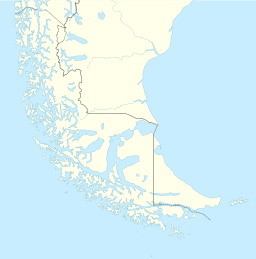
Potrok Aike is a maar in the Patagonian province of Santa Cruz, Argentina. It has a roughly circular shape and an average diameter of 2,700 metres. It is located just 2,200 metres north of the Argentina-Chile border. It is a maar lake and part of the Pali-Aike Volcanic Field. The Potrok Aike Maar Lake Sediment Archive Drilling Project (PASADO) bore a number of ICDP drill holes for October–November 2008. The aim is to investigate the crater-filling sediments and the underlying volcaniclastic deposits.

The Pali-Aike volcanic field is a volcanic field along the Argentina–Chile border. It is part of a family of back-arc volcanoes in Patagonia, which formed from processes involving the collision of the Chile Ridge with the Peru–Chile Trench. It lies farther east than the Austral Volcanic Zone, the volcanic arc that makes up the Andean Volcanic Belt at this latitude. Pali-Aike formed over sedimentary rock of Magallanes Basin, a Jurassic-age basin starting from the late Miocene as a consequence of regional tectonic events.

The Southern Hudson Bay taiga is a terrestrial ecoregion, as classified by the World Wildlife Fund, which extends along the southern coast of Hudson Bay and resides within the larger taiga biome. The region is nearly coterminous with the Hudson Plain, a Level I ecoregion of North America as designated by the Commission for Environmental Cooperation (CEC) in its North American Environmental Atlas.