
A glacier is a persistent body of dense ice that is constantly moving under its own weight. A glacier forms where the accumulation of snow exceeds its ablation over many years, often centuries. It acquires distinguishing features, such as crevasses and seracs, as it slowly flows and deforms under stresses induced by its weight. As it moves, it abrades rock and debris from its substrate to create landforms such as cirques, moraines, or fjords. Although a glacier may flow into a body of water, it forms only on land and is distinct from the much thinner sea ice and lake ice that form on the surface of bodies of water.

Borith Lake is a lake in Gojal, Hunza Valley in Gilgit–Baltistan, Pakistan. The altitude of Borith is roughly 2,600 metres (8,500 ft) above sea level.

The Byrd Glacier is a major glacier in Antarctica, about 136 km (85 mi) long and 24 km (15 mi) wide, draining an extensive area of the polar plateau and flowing eastward between the Britannia Range and Churchill Mountains to discharge into the Ross Ice Shelf at Barne Inlet. Its valley below the glacier used to be recognised as one of the lowest points not to be covered by water on Earth, reaching 2,780 metres below sea level. It was named by the NZ-APC after Rear Admiral Byrd, US Navy Antarctic explorer.

The Priestley Glacier is a major valley glacier, about 96 km (60 mi) long, originating at the edge of the Polar Plateau of Victoria Land, Antarctica. The glacier drains southeast between the Deep Freeze and Eisenhower Ranges to enter the northern end of the Nansen Ice Sheet.

Ferrar Glacier is a glacier in Antarctica. It is about 35 nautical miles long, flowing from the plateau of Victoria Land west of the Royal Society Range to New Harbour in McMurdo Sound. The glacier makes a right (east) turn northeast of Knobhead, where it also feeds the upper end of the Taylor Glacier, which flows on the other (northern) side of the Kukri Hills from the Ferrar Glacier, which continues east along the south side of the Kukri Hills to New Harbour.

A moulin is a roughly circular, vertical well-like shaft formed where a surface meltstream exploits a weakness in the ice. The term is derived from the French word for mill.
Hispar Glacier is a 49 km (30 mi) long glacier in the Karakoram Mountains of Gilgit–Baltistan, Pakistan which meets the 67 km (42 mi) long Biafo Glacier at the Hispar La (Pass) at an altitude of 5,128 m (16,824 ft) to create the world's longest glacial system outside of the polar regions.
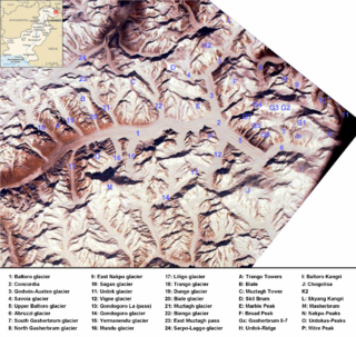
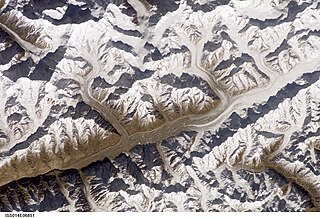
The Abruzzi Glacier is a glacier north of the Baltoro Kangri peak in Gilgit-Baltistan, Pakistan. The glacier joins the Baltoro Glacier that flows northwest in the beginning and then turns westward. The glacier provides superb views of K2, the highest peak in Pakistan.
Sherpi Kangri is a mountain peak in the Karakoram Range. It lies six km south of Ghent Kangri and ten km northwest of Saltoro Kangri.

Gondogoro Glacier or Gondoghoro Glacier is glacier near Concordia in Gilgit-Baltistan, Pakistan. It serves as an alternative means to reach Concordia; the confluence of Baltoro Glacier and Godwin-Austen Glacier.

Glacier morphology, or the form a glacier takes, is influenced by temperature, precipitation, topography, and other factors. The goal of glacial morphology is to gain a better understanding of glaciated landscapes and the way they are shaped. Types of glaciers can range from massive ice sheets, such as the Greenland ice sheet, to small cirque glaciers found perched on mountain tops. Glaciers can be grouped into two main categories:

The San Rafael Glacier is one of the major outlet glaciers of the Northern Patagonian Ice Field in southern Chile and is the tidewater glacier nearest the equator. It calves into the Laguna San Rafael and is contained within Laguna San Rafael National Park.
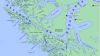
Almirantazgo Fjord, also known as Almirantazgo Sound or Admiralty Sound, is a Chilean fjord located in the far south of the country at 54°19′S69°30′W. The fjord cuts deeply into the west coast of the Isla Grande de Tierra del Fuego, extending southeastwards from the Whiteside Channel, which separates Isla Grande from Dawson Island. On its south side several smaller fjords and bays make significant indentations into the north coastline of the Cordillera Darwin. One of these, Ainsworth Bay, is home to a colony of elephant seals. Azopardo River empties into the head of the fjord.

The Nordenskjöld is a lake in Torres del Paine National Park in the Magallanes Region, southern Chile. The lake is named after the Swede Otto Nordenskiöld who discovered the lake in the beginning of the 20th century. The outfall of Nordenskjöld Lake consists of a waterfall known as Salto Grande. At this western end of the lake on the southern side is an abundance of wildlife including wild grazing guanaco.
Newall Glacier is a glacier in the east part of the Asgard Range of Victoria Land, flowing east between Mount Newall and Mount Weyant into the Wilson Piedmont Glacier. In its uppermost névé area sits Kaminuma Crag, a craggy, island-like nunatak, 0.75 nautical miles (1.4 km) long, rising to 1,750 metres (5,740 ft) high.
Garrard Glacier is a glacier in the Queen Alexandra Range of Antarctica, draining eastward from the névé between Mount Lockwood and Mount Kirkpatrick and entering Beardmore Glacier south of Bell Bluff. It appears that the British Antarctic Expedition, 1910–13, applied the name "Garrard Glacier" to the feature which had been named Bingley Glacier by Ernest Shackleton in 1908. The area was surveyed by the New Zealand Geological Survey Antarctic Expedition (1961–62), who retained Bingley Glacier on the basis of priority and reapplied the name Garrard Glacier to this previously unnamed feature. The name is for Apsley Cherry-Garrard, a zoologist with the British Antarctic Expedition.
Kansas Glacier is a steep glacier, 25 nautical miles (46 km) long, draining northeast from Stanford Plateau, Antarctica, to enter Reedy Glacier just north of Blubaugh Nunatak. It was mapped by the United States Geological Survey from surveys and U.S. Navy air photos, 1960–64, and was named by the Advisory Committee on Antarctic Names for the University of Kansas, Lawrence, Kansas, which has sent a number of research personnel to Antarctica.
Alyabiev Glacier is a glacier in Antarctica, flowing south from Gluck Peak into Boccherini Inlet and lies about 3 miles (5 km) West of Arensky Glacier on Beethoven Peninsula, Alexander Island, It was named by the USSR Academy of Sciences, in 1987, after Alexander Alyabiev (1787-1851), the Russian composer.

Holanda Glacier is a glacier located in Alberto de Agostini National Park, Chile. It is located at the east end of a group of glaciers line up on the north shore of the northwest arm of the Beagle Channel. The glacier terminus ends in a small proglacial lake.
