Tierra del Fuego is an archipelago off the southernmost tip of the South American mainland, across the Strait of Magellan.

The Magallanes Region, officially the Magallanes y la Antártica Chilena Region, is one of Chile's 16 first order administrative divisions. It is the southernmost, largest, and second least populated region of Chile. It comprises four provinces: Última Esperanza, Magallanes, Tierra del Fuego, and Antártica Chilena.
Los Glaciares National Park is a federal protected area in Santa Cruz Province, Argentina.

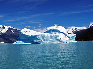
The Perito Moreno Glacier is a glacier located in Los Glaciares National Park in southwest Santa Cruz Province, Argentina. It is one of the most important tourist attractions in the Argentine Patagonia.

Tronador is an extinct stratovolcano in the southern Andes, located along the border between Argentina and Chile, near the Argentine city of Bariloche. The mountain was named Tronador by locals in reference to the sound of falling seracs. With an altitude of 3,470 metres (11,380 ft), Tronador stands more than 1,000 m above nearby mountains in the Andean massif, making it a popular mountaineering destination. Located inside two national parks, Nahuel Huapi in Argentina and Vicente Pérez Rosales in Chile, Tronador hosts a total of eight glaciers, which are currently retreating due to warming of the upper troposphere.

Monte Fitz Roy is a mountain in Patagonia, on the border between Argentina and Chile. It is located in the Southern Patagonian Ice Field, near El Chaltén village and Viedma Lake. It was first climbed in 1952 by French alpinists Lionel Terray and Guido Magnone.

Laguna San Rafael National Park is a park located on the Pacific coast of southern Chile. The park is named for the San Rafael Lagoon formed by the retreat of the San Rafael Glacier. Created in 1959, it covers an area of 17,420 km2 (6,726 sq mi) and includes the Northern Patagonian Ice Field. A fjord more than 16 km (10 mi) long is one of the park's principal attractions.

The Southern Patagonian Ice Field, located at the Southern Patagonic Andes between Chile and Argentina, is the world's second largest contiguous extrapolar ice field. It is the bigger of two remnant parts of the Patagonian Ice Sheet, which covered all of southern Chile during the last glacial period, locally called the Llanquihue glaciation.

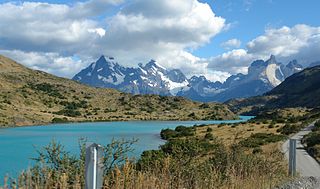
Torres del Paine National Park is a national park encompassing mountains, glaciers, lakes, and rivers in southern Chilean Patagonia. The Cordillera del Paine is the centerpiece of the park. It lies in a transition area between the Magellanic subpolar forests and the Patagonian Steppes. The park is located 112 km (70 mi) north of Puerto Natales and 312 km (194 mi) north of Punta Arenas. The park borders Bernardo O'Higgins National Park to the west and the Los Glaciares National Park to the north in Argentine territory. Paine means "blue" in the native Tehuelche (Aonikenk) language and is pronounced PIE-neh, while Torres means "towers". It was established as a National Park in 1959.

Última Esperanza is one of four provinces in the southern Chilean region of Magallanes and Antártica Chilena. The capital is Puerto Natales and it is named after Última Esperanza Sound. A section of its border with Argentina in the Southern Patagonian Ice Field is under dispute.

Bernardo O'Higgins National Park is the largest of the protected areas in Chile, covering an area of 3,525,901 ha, in both the Aysén and Magallanes and Antártica Chilena regions. Management of this and other national parks in Chile is entrusted to the Corporación Nacional Forestal (CONAF). The park is named after General Bernardo O'Higgins, the first head of state of the Republic of Chile. Los Glaciares National Park (Argentina) and Torres del Paine National Park are its neighbours to the east, Laguna San Rafael National Park is located to the north, the Alacalufes National Reserve to the southwest, and the Katalalixar National Reserve to the northwest.

Alberto de Agostini National Park is a protected area that was created on January 22, 1965, on land that was formerly part of the "Hollanda" forest reserve and "Hernando de Magallanes National Park". It covers 1,460,000 hectares and includes the Cordillera Darwin mountain range, which is the final land-based stretch of the Andes before it becomes a chain of mountains appearing as small islands that sink into the Pacific Ocean and the Beagle Channel.

The Nordenskjöld is a lake in Torres del Paine National Park in the Magallanes Region, southern Chile. The lake is named after the Swede Otto Nordenskiöld who discovered the lake in the beginning of the 20th century. The outfall of Nordenskjöld Lake consists of a waterfall known as Salto Grande. At this western end of the lake on the southern side is an abundance of wildlife including wild grazing guanaco.

The Zona Austral is one of the five natural regions into which CORFO divided continental Chile in 1950 corresponding to the Chilean portion of Patagonia. It is surrounded by the Zona Sur and the Chacao Channel to the north, the Pacific Ocean and Drake's Passage to the south and west, and the Andean mountains and Argentina to the east. If excluding Chiloé Archipelago, Zona Austral covers all of Chilean Patagonia.
Paine River(Río Paine) is a river located in the Magallanes Region of Chile. The river rises from its source in Dickson Lake and flows east for nine kilometres (km) to Paine Lake. After flowing through the lake, the river runs for 15 km, first southward and then westward to Nordenskjöld Lake. This part of the river's course includes the Paine Cascade.

Lake Pehoé is a surface water body located in Torres del Paine National Park, in the Magallanes Region of southern Chile. The lake is fed mainly by Paine River through the Nordenskjöld Lake, but it also receives the water from the outlet of Skottsberg Lake.

Tortel is a Chilean commune located at the outflow of the Baker River and Pascua River to the Pacific Ocean. It lies between the Northern and Southern Patagonian Ice Field in the Capitán Prat Province in the Aysén Region. The commune is administered by the municipality in Caleta Tortel, the principal settlement.

Reclus, also written as Reclús, is a volcano located in the Southern Patagonian Ice Field, Chile. Part of the Austral Volcanic Zone of the Andes, its summit rises 1,000 metres (3,300 ft) above sea level and is capped by a crater about 1 kilometre (0.62 mi) wide. Close to the volcano lies the Amalia Glacier, which is actively eroding Reclus.
Hiking in Chile is characterized by a wide range of environments and climates for hikers, which largely results from Chile's unusual, ribbon-like shape, which is 4,300 kilometres long and on average 175 kilometres wide. These range from the world's driest desert, the Atacama, in the north, through a Mediterranean climate in the center, to the glaciers, fjords and lakes of Patagonia in the south.

The last glacial period and its associated glaciation is known in southern Chile as the Llanquihue glaciation. Its type area lies west of Llanquihue Lake where various drifts or end moraine systems belonging to the last glacial period have been identified. The glaciation is the last episode of existence of the Patagonian Ice Sheet. Around Nahuel Huapi Lake the equivalent glaciation is known as the Nahuel Huapi Drift.