The Magallanes Region, officially the Magallanes y la Antártica Chilena Region, is one of Chile's 16 first order administrative divisions. It is the southernmost, largest, and second least populated region of Chile. It comprises four provinces: Última Esperanza, Magallanes, Tierra del Fuego, and Antártica Chilena.
Los Glaciares National Park is a federal protected area in Santa Cruz Province, Argentina.

The Cordillera Paine is a mountain group in Torres del Paine National Park in Chilean Patagonia. The cordillera is located 280 km (170 mi) north of Punta Arenas, and about 1,960 km (1,220 mi) south of the Chilean capital Santiago. It belongs to the Commune of Torres del Paine in Última Esperanza Province of Magallanes and Antártica Chilena Region. No accurate surveys have been published, and published elevations have been claimed to be seriously inflated, so most of the elevations given on this page are approximate. Paine means "blue" in the native Tehuelche (Aonikenk) language and is pronounced PIE-nay.

Puerto Natales is a city in Chilean Patagonia. It is the capital of both the commune of Natales and the province of Última Esperanza, one of the four provinces that make up the Magallanes and Antartica Chilena Region in the southernmost part of Chile. Puerto Natales is the only city in the province. It is located 247 km (153 mi) northwest of Punta Arenas. It is the final passenger port of call for the Navimag ferry sailing from Puerto Montt into the Señoret Channel as well as the primary transit point for travellers to Torres del Paine National Park, Chile.

The Southern Patagonian Ice Field, located at the Southern Patagonic Andes between Chile and Argentina, is the world's second largest contiguous extrapolar ice field. It is the bigger of two remnant parts of the Patagonian Ice Sheet, which covered all of southern Chile during the last glacial period, locally called the Llanquihue glaciation.

Torres del Paine National Park is a national park encompassing mountains, glaciers, lakes, and rivers in southern Chilean Patagonia. The Cordillera del Paine is the centerpiece of the park. It lies in a transition area between the Magellanic subpolar forests and the Patagonian Steppes. The park is located 112 km (70 mi) north of Puerto Natales and 312 km (194 mi) north of Punta Arenas. The park borders Bernardo O'Higgins National Park to the west and the Los Glaciares National Park to the north in Argentine territory. Paine means "blue" in the native Tehuelche (Aonikenk) language and is pronounced PIE-neh. It was established as a National Park in 1959.

Última Esperanza is one of four provinces in the southern Chilean region of Magallanes and Antártica Chilena. The capital is Puerto Natales and it is named after Última Esperanza Sound. A section of its border with Argentina in the Southern Patagonian Ice Field is under dispute.

Yelcho Lake is a large fjord-shaped lake located in Chilean Patagonia, in southern Palena province of Los Lagos Region, Chile. The lake receives the waters of the Futaleufu River at its southern tip, near the tiny settlement of Puerto Ramirez. The river then flows northward through mountainous and glaciated terrain, until it outflows via the Yelcho River north-west and empties into Gulf of Corcovado, near Chaitén. The lake is a popular destination for fly fishing, and several lodges and hotels operate on its shores. Yelcho Lake is most frequently accessed via the town of Chaitén to the north. Two small commercial airlines operate daily flights from Puerto Montt. Another option is ferry service direct from Puerto Montt, the bimodal ferry service from the town of Hornopiren, or direct from the port of Quellón on the island of Chiloe on the other side of the Gulf of Corcovado. Traffic on the Carretera Austral along the western shore of Yelcho Lake was interrupted in December 2017 due to a mudslide in the settlement of Villa Santa Lucía, which killed 22 people. The road reopened in February 2018.

The Nordenskjöld is a lake in Torres del Paine National Park in the Magallanes Region, southern Chile. The lake is named after the Swede Otto Nordenskjöld, who explored the region at the beginning of the 20th century. The outfall of Nordenskjöld Lake consists of a waterfall known as Salto Grande. At this western end of the lake on the southern side is an abundance of wildlife, including grazing guanaco.

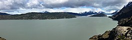
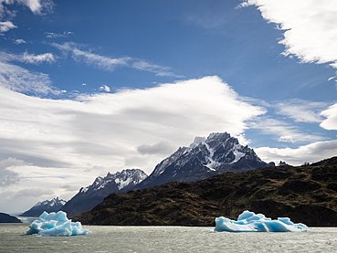
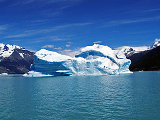
Grey Glacier is a glacier in the Southern Patagonian Ice Field, just west of the Cordillera del Paine. It flows southward into the lake of the same name. Before dividing in two at its front end, the glacier is 6 kilometers wide and over 30 meters high. In 1996, it occupied a total area of 270 km2 (100 sq mi) and a length of 28 km (17 mi). In November 2017 a large iceberg broke off the glacier.

Sarmiento Lake is a lake located in Torres del Paine National Park, in the Magallanes Region of southern Chile. It is named after Spanish explorer Pedro Sarmiento de Gamboa, and gives its name to one of the areas in the National Park Torres del Paine. Its edge is marked by extensive calcium carbonate "Thrombolites" deposits, possibly from hydrothermal activity in the lake.

Lake Pehoé is a surface water body located in Torres del Paine National Park, in the Magallanes Region of southern Chile. The lake is fed mainly by Paine River through the Nordenskjöld Lake, but it also receives the water from the outlet of Skottsberg Lake.

Torres del Paine is a Chilean commune located in the inland of Última Esperanza Province and Magallanes Region. The commune is administered by the municipality in Cerro Castillo, the major settlement in the commune. Torres del Paine National Park lies within the commune. Paine means "blue" in the native Tehuelche (Aonikenk) language and is pronounced PIE-nay.

Dickson Lake is a glacier lake in southern Patagonia located in the Southern Patagonian Ice Field, which since 1998 has been transformed into an international lake as it is crossed by the international boundary between Argentina and Chile due to the retreat of the Dickson glacier. Until that year, Dickson Lake was entirely within Chilean territory, at the northern end of the Torres del Paine National Park in the Magallanes y la Antártica Chilena Region, but it was unified with a lake that began to form in the 1980s by defrosting the melting of the Dickson, Cubo and Frías glaciers. That lake was on the Argentine side when the Agreement was signed to specify the route of the limit from Mount Fitz Roy to the Daudet Hill of 1998, in a sector adjacent to the Los Glaciares National Park, but without being part of it. The lake is fed by the glacier that shares its name and is drained by the Paine River. It receives the waters of Los Perros River, which starts at a proglacial lake that was formed during the retreat of Los Perros Glacier.

Since the mid-1990s, tourism in Chile has become one of the main sources of income for the country, especially in its most extreme areas. In 2005, this sector grew by 13.6%, generating more than US$500 million, equivalent to 1.33% of the national GDP.

Reclus, also written as Reclús, is a cinder cone and stratovolcano located in the Southern Patagonian Ice Field, Chile. Part of the Austral Volcanic Zone of the Andes, its summit rises 1,000 metres (3,300 ft) above sea level and is capped by a crater about 1 kilometre (0.62 mi) wide. Close to the volcano lies the Amalia Glacier, which is actively eroding Reclus.
Hiking in Chile is characterized by a wide range of environments and climates for hikers, which largely results from Chile's unusual, ribbon-like shape, which is 4,300 kilometres long and on average 175 kilometres wide. These range from the world's driest desert, the Atacama, in the north, through a Mediterranean climate in the center, to the glaciers, fjords and lakes of Patagonia in the south.

Lagunas de Montebello, or Montebello Lakes, is a national park in the Mexican state of Chiapas, near the border with Guatemala, comprising 59 multi-colored lakes in a pine forest and two Maya ruins. It was the first national park in Chiapas when created in 1959, and in 2009 the park was designated a Biosphere Reserve by UNESCO.

Lake Cholila is a lake in Chubut Province, Argentina. Lake Cholila is the uppermost of several large lakes in the Futaleufú River system of Argentina that via Yelcho Lake and the Yelcho River flows into the Pacific Ocean in Chile. The lake is of glacial origin and occupies a narrow east to west valley between glaciated peaks of the Andes.
The Paleolake Tehuelche is the name for several former lakes that existed in the area of Torres del Paine in southern Patagonia. These were proglacial lakes that existed next to the Patagonian Ice Sheet during the Late Pleistocene and Early Holocene. Some of the evidence of the lakes stem from lake terraces observable at present but these is some uncertainty on which terraces are associated to which lake or lake stage.