Related Research Articles

The Aconcagua River is a river in Chile that rises from the conflux of two minor tributary rivers at 1,430 metres (4,690 ft) above sea level in the Andes, Juncal River from the east and Blanco River from the south east. The Aconcagua river flows westward through the broad Aconcagua valley and enters the Pacific Ocean near the city of Concon, 20 kilometres (12 mi) north of Valparaíso.

Araucanía or Araucana was the Spanish name given to the region of Chile inhabited by the Mapuche peoples known as the Moluche in the 18th century. Prior to the Spanish conquest of Chile, the lands of the Moluche lay between the Itata River and Toltén River.

The Picunche, also referred to as picones by the Spanish, were a Mapudungun-speaking people living to the north of the Mapuches or Araucanians and south of the Choapa River and the Diaguitas. Until the Conquest of Chile the Itata was the natural limit between the Mapuche, located to the south, and Picunche, to the north. During the Inca attempt to conquer Chile the southern Picunche peoples that successfully resisted them were later known as the Promaucaes.

The Perquilauquén River is a tributary of the Loncomilla river, in the Maule Region of Chile. The river joins the Longaví to form the Loncomilla, a tributary of the Maule river.

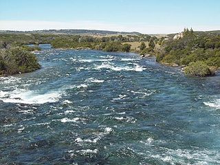
The Itata River flows in the Ñuble Region, southern Chile.
The Baker River is a river located in the Aysén del General Carlos Ibáñez del Campo Region of the Chilean Patagonia. It is Chile's largest river in terms of volume of water. The river flows out of Bertrand Lake, which is fed by General Carrera Lake. It runs along the east side of the Northern Patagonian Ice Field and empties into the Pacific Ocean, near the town of Caleta Tortel. The river forms a delta, dividing into two major arms, of which only the northernmost one is navigable.

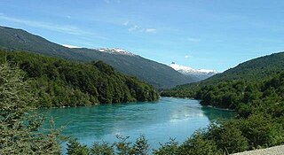
The Valdivia River or Río Valdivia, as it is known locally, is a major river in southern Chile. It is the continuation of the Calle-Calle River, from the point where it meets the Cau-Cau River in the city of Valdivia. The Valdivia river ends in Corral Bay, on the Pacific coast. Other tributaries are the Cruces River, the Tornagaleones River and the Futa River. Pedro de Valdivia Bridge crosses the river in downtown Valdivia.

Caucau River is minor river in the city of Valdivia, southern Chile. Caucau River acts as a regulating channel between Cruces River and Calle-Calle River forming the Isla Teja island in front of the city centre. Its confluence with Calle-Calle River marks the beginning of Valdivia River. '

The Bueno River is a river in southern Chile. It originates in Ranco Lake and like most of Chile rivers it drains into the Pacific Ocean at the southern boundary of the Valdivian Coastal Reserve. Its lower flow forms the border between Osorno Province and Ranco Province. Traditionally, it marks also the northern boundary of the indigenous Huilliche territory known as Futahuillimapu. The river passes through Río Bueno commune and city that takes name from the river.

Limarí River is a river of Chile located in the Coquimbo Region. The river is formed at the confluence of the Hurtado and Grande rivers, about 4 km east of the city of Ovalle. The lower course of the river borders the southern portion of Bosque de Fray Jorge National Park. This watershed includes presence of the endangered Chilean Wine Palm, Jubaea chilensis, which prehistorically had a much broader distribution, but presently is threatened by the expanding human population in central Chile.

Vergara River is a river located in the Intermediate Depression of Chile. The river rises at the junction of the Malleco and Rehue rivers, close to the city of Angol.The Nahuelbuta Range barrier forces the river to flow northward. At the latitude of the town of Renaico, the Vergara is joined by its main affluent, the Renaico. From its confluence with the latter river to its confluence with the Liñeco Creek, the Vergara River marks the boundary between the regions of Bío Bío and La Araucanía.

Pichoy Airport is an airport 32 kilometres (20 mi) northeast of Valdivia, a city in the Los Ríos Region of Chile. The airport lies next to Pichoy River.

The Huahum River is a river in southern Chile and Argentina. It drains the waters of Lácar Lake in Argentina to Pirihueico Lake in Chile. The river gives name to Huahum Pass, an international mountain pass on the border between Chile and Argentina.
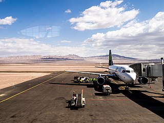
Desierto de Atacama Airport is an airport serving the region around Copiapó, the capital of the Atacama Region of Chile. The airport is in the desert north of the Copiapó River, 16 kilometres (9.9 mi) inland from the Pacific coast.
Renaico River is a Chilean river that, along all its length, straddles the border between the regions of Bío Bío and La Araucanía. Renaico River rises from the northwest flank of Cordillera de Pemehue, a western spur of the Andes Mountains, north of Tolhuaca volcano. In its upper course, the river parallels the east and north border of Malleco National Reserve. The river terminates approximately 7 km downstream from the city of Renaico, where it joins the Vergara River.
Pillanleufú River is a river in Futrono, southern Chile. It drains waters from the southern and eastern slopes of Mocho-Choshuenco volcano to Maihue Lake, which in turn flows by Calcurrupe River into Ranco Lake. The river flows in a north-south direction along the Liquiñe-Ofqui Fault.
Lingue River is a river in the commune of Mariquina, southern Chile. It originates in the Valdivian Coast Range and flows westward where it empties in the Pacific Ocean at the town of Mehuín. On its northern boundary, the river reaches the basin of the river Queule. On the southern end, it reaches the Valdivia river basin.
The Palena River or Carrenleufú is a river shared by Chile and Argentina in Southern Lakes Region. It drains the waters of the Vintter Lake, also shared by these nations, and it flows into the Pacific Ocean. 56.5% of the river basin lies in Chile.
The San Ramón is a Chilean geological fault, located in eastern Santiago Metropolitan Region, passing through the eastern part of Santiago marking the boundary between the Chilean Central Valley and the Andes. As an active thrust fault it constitutes a seismic hazard zone for the densely populated Santiago. A large number of homes and educational centers have been built on or near the fault, along with a gas plant in Peñalolén. The Chilean Nuclear Energy Commission has a reactor in La Reina, very close to the fault, which has raised concerns among the population. It runs 5 kilometers underground and extends for 25 kilometers in a north–south direction, lying between the Mapocho River and Maipo River. It is known to pass underneath the communes of Vitacura, Las Condes, La Reina, Peñalolén, La Florida and Puente Alto, and suspected to continue into Lo Barnechea and Pirque at its extremes. Due to its shallowness, it can cause very destructive superficial earthquakes with a magnitude around 7 on the Richter scale, with a general recurrence period of over 300 years.
El Tuqui Airport, is an airport serving Ovalle, a city in the Coquimbo Region of Chile.
References
- ↑ "The Lagoons of Torres del Paine National Park". Autochtone Voyage (in French). 2017-08-03. Retrieved 2024-12-19.