
Viedma is a subglacial volcano whose existence is questionable. It is supposedly located below the ice of the Southern Patagonian Ice Field, an area disputed between Argentina and Chile. The 1988 eruption deposited ash and pumice on the ice field and produced a mudflow that reached Viedma Lake. The exact position of the edifice is unclear, both owing to the ice cover and because the candidate position, the "Viedma Nunatak", does not clearly appear to be of volcanic nature.

An ice field is a mass of interconnected valley glaciers on a mountain mass with protruding rock ridges or summits. They are often found in the colder climates and higher altitudes of the world where there is sufficient precipitation for them to form. The higher peaks of the underlying mountain rock that protrude through the icefields are known as nunataks. Ice fields are larger than alpine glaciers, but smaller than ice caps and ice sheets. The topography of ice fields is determined by the shape of the surrounding landforms, while ice caps have their own forms overriding underlying shapes.

Brüggen Glacier, also known as Pío XI Glacier, is in southern Chile and is the largest western outflow from the Southern Patagonian Ice Field. Now about 66 km (41 mi) in length, it is the longest glacier in the southern hemisphere outside Antarctica. Unlike most glaciers worldwide, it advanced significantly from 1945 to 1976, Brüggen surged 5 km (3.1 mi) across the Eyre Fjord, reaching the western shore by 1962 and cutting off Lake Greve from the sea. The glacier continued advancing both northward and southward in the fjord to near its present position before stabilizing. The growth covers a distance of more than 10 km (6.2 mi) north to south, adding nearly 60 square kilometres (23 sq mi) of ice. The glacier is named after the German geologist Juan Brüggen Messtorff.

The Northern Patagonian Ice Field, located in southern Chile, is the smaller of two remnant parts in which the Patagonian Ice Sheet in the Andes Mountains of southern South America can be divided. It is completely contained within the boundaries of Laguna San Rafael National Park.

The Southern Patagonian Ice Field, located at the Southern Patagonic Andes between Chile and Argentina, is the world's second largest contiguous extrapolar ice field. It is the bigger of two remnant parts of the Patagonian Ice Sheet, which covered all of southern Chile during the last glacial period, locally called the Llanquihue glaciation.

Torres del Paine National Park is a national park encompassing mountains, glaciers, lakes, and rivers in southern Chilean Patagonia. The Cordillera del Paine is the centerpiece of the park. It lies in a transition area between the Magellanic subpolar forests and the Patagonian Steppes. The park is located 112 km (70 mi) north of Puerto Natales and 312 km (194 mi) north of Punta Arenas. The park borders Bernardo O'Higgins National Park to the west and the Los Glaciares National Park to the north in Argentine territory. Paine means "blue" in the native Tehuelche (Aonikenk) language and is pronounced PIE-neh. It was established as a National Park in 1959.

The San Rafael Glacier is one of the major outlet glaciers of the Northern Patagonian Ice Field in southern Chile and is the tidewater glacier nearest the equator. It calves into the Laguna San Rafael and is contained within Laguna San Rafael National Park.
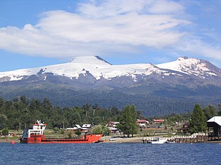
Mocho-Choshuenco is a glacier covered compound stratovolcano in the Andes of Los Ríos Region, Chile. It is made of the twin volcanoes Choshuenco in the northwest and the Mocho in the southeast. The highest parts of the volcano are part of the Mocho-Choshuenco National Reserve while the eastern slopes are partly inside the Huilo-Huilo Natural Reserve.

San Rafael Lake is an arc-shaped coastal lake located in the Aysén del General Carlos Ibáñez del Campo Region of Chile, within the national park that bears its name. To the north the lagoon is connected to the Moraleda Channel, to the south lies the Ofqui Isthmus. To the west and east lie the Taitao Peninsula and the Northern Patagonian Ice Field respectively.

O'Higgins Glacier is a glacier located in Bernardo O'Higgins National Park, Chile. It is one of the principal glaciers of the Southern Patagonian Ice Field. The summit of the active Lautaro volcano is the top of the accumulation zone of the glacier. The bulk of the glacier is part of the icefield plateau. It flows eastward into O'Higgins Lake and is about 2 km (1.2 mi) wide at the terminus.

Jorge Montt Glacier is a tidewater glacier located in the Aisén Region of Chile, south of the town of Caleta Tortel. It lies at the north end of the Southern Patagonian Ice Field, within Bernardo O'Higgins National Park. The mouth of Pascua River is located in the vicinity of the glacier calving front.

Grey Glacier is a glacier in the Southern Patagonian Ice Field, just west of the Cordillera del Paine. It flows southward into the lake of the same name. Before dividing in two at its front end, the glacier is 6 kilometers wide and over 30 meters high. In 1996, it occupied a total area of 270 km2 (100 sq mi) and a length of 28 km (17 mi). In November 2017 a large iceberg broke off the glacier.

Nef Glacier is a glacier located in Laguna San Rafael National Park, in the Aysén del General Carlos Ibáñez del Campo Region of Chile. It trends southeast from Cerro Largo to its terminus in the lake that shared its name.

Bernardo Glacier is one of the largest glaciers in the Southern Patagonian Ice Field. It is located northeast of Témpano Glacier, within Bernardo O'Higgins National Park in Chile. The glacier flows westward Bernardo Fjord.

Tyndall Glacier or Geike Glacier is one of the largest glaciers in the Southern Patagonian Ice Field. It is located in the Torres del Paine National Park, Chile. The glacier has its main calving front in Geikie Lake and like its neighbor, Grey Glacier, it has been significantly retreating for the last years. The glacier is named after the Irish glaciologist John Tyndall.

Dickson Lake is a glacier lake in southern Patagonia located in the Southern Patagonian Ice Field, which since 1998 has been transformed into an international lake as it is crossed by the international boundary between Argentina and Chile due to the retreat of the Dickson glacier. Until that year, Dickson Lake was entirely within Chilean territory, at the northern end of the Torres del Paine National Park in the Magallanes y la Antártica Chilena Region, but it was unified with a lake that began to form in the 1980s by defrosting the melting of the Dickson, Cubo and Frías glaciers. That lake was on the Argentine side when the Agreement was signed to specify the route of the limit from Mount Fitz Roy to the Daudet Hill of 1998, in a sector adjacent to the Los Glaciares National Park, but without being part of it. The lake is fed by the glacier that shares its name and is drained by the Paine River. It receives the waters of Los Perros River, which starts at a proglacial lake that was formed during the retreat of Los Perros Glacier.

Amalia Glacier, also known as Skua Glacier, is a tidewater glacier located in Bernardo O'Higgins National Park, Chile, on the edge of the Sarmiento Channel. The glacier originates in the Southern Patagonian Ice Field. From 1945 to 1986, its terminus retreated 7 km (4.3 mi), being, along with the recession of the O'Higgins Glacier, the most dramatic retreat of the glaciers of the mentioned icefield during that period.
Steffen Glacier is a major outlet glacier of the Northern Patagonian Ice Field in Aysén del General Carlos Ibáñez del Campo Region of Chile. It is the southernmost outlet glacier of the Northern Patagonian Ice Field and ends up in a lagoon from where Huemules River is born. The glacier is named after Hans Steffen a German geographer who explored Aysén del General Carlos Ibáñez del Campo Region on behalf of the Chilean government before the General Treaty of Arbitration between Chile and the Argentine Republic of 1902.
