
The Menai Strait is a narrow stretch of shallow tidal water about 25 km (16 mi) long, which separates the island of Anglesey from the mainland of Wales. It varies in width from 400 metres (1,300 ft) from Fort Belan to Abermenai Point to 1,100 metres (3,600 ft) from Traeth Gwyllt to Caernarfon Castle. It then narrows to 500 metres (1,600 ft) in the middle reaches and then it broadens again. At Bangor, Garth Pier, it is 900 metres (3,000 ft) wide. It then widens out, and the distance from Puffin Island to Penmaenmawr is about 8 kilometres (5.0 mi).

Menai Bridge is a town and community on the Isle of Anglesey in north-west Wales. It overlooks the Menai Strait and lies by the Menai Suspension Bridge, built in 1826 by Thomas Telford, just over the water from Bangor. With a population of 3,376, it is the fifth largest town on the island. The built-up area including Llandegfan had a population of 4,958.
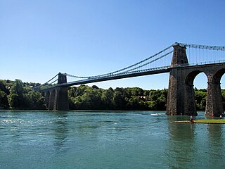
The Menai Suspension Bridge is a suspension bridge spanning the Menai Strait between the island of Anglesey and the mainland of Wales. Designed by Thomas Telford and completed in 1826, it was the world's first major suspension bridge. The bridge still carries road traffic and is a Grade I listed structure.
Red Wharf Bay, also known as Traeth Coch, is a village and a wide sandy bay in the Anglesey Area of Outstanding Natural Beauty on the east coast of the island of Anglesey in Wales. The bay lies between the villages of Pentraeth and Benllech. It is also close to Castell Mawr Rock, thought to be the site of an Iron Age fort.

Ynys Gored Goch, sometimes Ynys Gorad Goch, is a small island in the Menai Strait between Gwynedd and Anglesey in north Wales. It is situated in the stretch of the strait called the Swellies between Thomas Telford's Menai Suspension Bridge and Robert Stephenson's Britannia Bridge.

Puffin Island is an uninhabited island off the eastern tip of Anglesey, Wales. It was formerly known as Priestholm in English and Ynys Lannog in Welsh. A hermitage was established here around the 6th century, and there are remains of a 12th-century monastery on the island. The island is also a Special Protection Area for wildlife.

The Swellies is a stretch of the Menai Strait in North Wales. The most popular use of the name is for the stretch between the Britannia Bridge and the Menai Bridge.

Ynys Castell is a small island in the Menai Strait which separates Anglesey and mainland Wales. It is an extruding piece of Precambrian schist lying to one side of the Afon Cadnant estuary. It lies between Ynys y Bîg and Ynys Gaint. There is a causeway running to the island that is covered at high tide. On the island there is a private house. Ynys Castell means Castle Island in Welsh.

Ynys y Bîg is a small private island in the Menai Strait attached to the island of Anglesey by a wooden bridge. The bridge runs from the grounds of a private house, itself also called Ynys y Bîg, preventing any public access. The bridge fell into disrepair but was reconstructed in 2019.

Ynys Gaint is a small island in the Menai Strait connected to the town of Menai Bridge on Anglesey by a causeway and also a concrete bridge erected by Sir William Fison in the 1930s. Literally translated Ynys Gaint mean Kent Island.
Church Island, also known as Llandysilio Island, is a small island in the Menai Strait on the shores of Anglesey to which it is attached by a short causeway that is reachable only on foot. The dominant feature of the island is with St Tysilio's Church, constructed in the 15th century, its churchyard, and a grade-II listed war memorial. The 20th-century bard Cynan is among several notable people buried in the churchyard. The Anglesey Coastal Path passes the head of the causeway.
The Anglesey Coastal Path is a 200-kilometre (124 mi) long-distance footpath around the island of Anglesey in North Wales. The route is part of the Wales Coast Path.

The Isle of Anglesey County Council is the local authority for the county of Anglesey, one of the principal areas of Wales. Since 2022 the council has 35 councillors who represent 11 multi-member electoral wards.
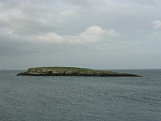
Ynys Moelfre is a small island off the coast of Anglesey, Wales. At low tide it has a maximum length of 261 metres and a maximum width of 121 metres with a maximum area of 6.6 acres (27,000 m2). The nearest settlement to the island is the village of Moelfre, and the two are separated by a shallow channel called Y Swnt, which is never more than 194 metres wide and can at low tide only be waist-deep all the way across. At extreme low Spring tides, it is possible to walk across to the island on dry ground all the way. Due to its proximity to the mainland there are grasses found on the island and a few wild flowers. Species of birds that can be found on the island include gulls, terns, gannets, fulmars, and Great/Arctic skuas. A colony of seals live there and porpoises are occasionally seen also. There are, however, no man-made structures. It is referred to by some locals as Rat Island.

The A4080 is a British A road which is located on the Island of Anglesey, Wales. It follows a very roundabout route from the A5 road at Llanfairpwllgwyngyll via Newborough and Rhosneigr back to the A55 and the A5 about 9 miles (14 km) south of Holyhead. In all the road is about 17 miles (27 km) long.

Anglesey is an island off the north-west coast of Wales. It forms a principal area known as the Isle of Anglesey, that includes Holy Island across the narrow Cymyran Strait and some islets and skerries. Anglesey island, at 260 square miles (673 km2), is the largest in Wales, the seventh largest in Britain, largest in the Irish Sea and second most populous there after the Isle of Man. Isle of Anglesey County Council administers 276 square miles (715 km2), with a 2011 census population of 69,751, including 13,659 on Holy Island. The Menai Strait to the mainland is spanned by the Menai Suspension Bridge, designed by Thomas Telford in 1826, and the Britannia Bridge, built in 1850 and replaced in 1980. The largest town is Holyhead on Holy Island, whose ferry service with Ireland handles over two million passengers a year. The next largest is Llangefni, the county council seat. From 1974 to 1996 Anglesey was part of Gwynedd. Most full-time residents are habitual Welsh speakers. The Welsh name Ynys Môn is used for the UK Parliament and Senedd constituencies. The postcodes are LL58–LL78. It is also a historic county of Wales.
Dindaethwy was in medieval times one of two commotes of the cantref of Rhosyr, in the south-east of the Isle of Anglesey. It was between the Menai Strait and Conwy Bay, and the Irish Sea and Red Wharf Bay.

St Tysilio's Church is a medieval church in the village of Menai Bridge, Anglesey, Wales. The current building dates from the early 15th century and underwent renovations in the 19th century. It was designated as a Grade II* listed building on 14 February 1967.

Afon Braint is a small tidal river on Anglesey, North Wales. There is a series of stepping stones near the village of Dwyran, and a Grade II bridge near Penmynydd. Until recently, there was an electoral ward named after the river.

The Menai Strait fish weirs are historically important fishing traps used in the fast-flowing tidal waters of the Menai Strait, which separates Anglesey from the rest of North Wales. The strait was particularly well suited to utilising fish weirs. The tidal waters pull huge volumes of water past the coastline with every tide, and the weirs and traps enabled fish to be concentrated into small holding areas from which they can be readily caught. Such methods are thought to have been used from earliest times, but the submerged and standing remains along both the Anglesey and Gwynedd coasts are from medieval and post-medieval periods, and in some cases were still in use into the 20th century.
