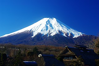
Mount Fuji, located on Honshū, is the highest volcano in Japan at 3,776.24 m (12,389 ft), 2nd-highest volcano of an island in Asia, and 7th-highest peak of an island in the world. It is an active stratovolcano that last erupted in 1707–1708. Mount Fuji lies about 100 kilometers (60 mi) south-west of Tokyo, and can be seen from there on a clear day. Mount Fuji's exceptionally symmetrical cone, which is snow-capped for about 5 months a year, is commonly used as a cultural icon of Japan and it is frequently depicted in many arts and photographs, as well as visited by sightseers and climbers.

The Forrestal Range is a largely snow-covered mountain range, about 105 km (65 mi) long, standing east of Dufek Massif and the Neptune Range in the Pensacola Mountains of Antarctica. Discovered and photographed on January 13, 1956 on a transcontinental patrol plane flight of U.S. Navy Operation Deep Freeze I from McMurdo Sound to the vicinity of the Weddell Sea and return.
The Patuxent Range or macizo Armada Argentina is a major range of the Pensacola Mountains, comprising the Thomas Hills, Anderson Hills, Mackin Table and various nunataks and ridges bounded by the Foundation Ice Stream, Academy Glacier and the Patuxent Ice Stream. Discovered and partially photographed on January 13, 1956 in the course of a transcontinental nonstop plane flight by personnel of U.S. Navy Operation Deep Freeze I from McMurdo Sound to Weddell Sea and return.
60P/Tsuchinshan, also known as Tsuchinshan 2, is a periodic comet in the Solar System with an orbital period of 6.79 years. Tsuchinshan is the Wade-Giles transliteration corresponding to the pinyin Zĭjīn Shān, which is Mandarin Chinese for "Purple Mountain".
Wilson Hills is a group of scattered hills, nunataks and ridges that extend NW-SE for about 110 kilometres (68 mi) between Matusevich Glacier and Pryor Glacier in Antarctica. They were discovered by Lieutenant Harry Pennell, Royal Navy, on the Terra Nova Expedition in February 1911 during Robert Falcon Scott's last expedition, and named after Dr. Edward A. Wilson, a zoologist with the expedition, who perished with Scott on the return journey from the South Pole.
Uranus Glacier is a glacier on the east coast of Alexander Island, Antarctica, 30 kilometres long and 10 km (6 mi) wide at its mouth, flowing east into George VI Sound immediately south of Fossil Bluff. Along the south face of the glacier is an east–west escarpment called Kuiper Scarp.

Jacka Glacier is a 0.8-mile (1.3 km) long glacier which flows northeast from Hayter Peak and terminates in icefalls opposite Vanhoffen Bluff on the north side of Heard Island in the southern Indian Ocean. The glacier appears to be roughly charted on an 1860 sketch map compiled by Captain H.C. Chester, an American sealer operating in the area during this period. It was surveyed in 1948 by the Australian National Antarctic Research Expeditions, and named by them for Fred J. Jacka, an expedition physicist.
Mount Ayres is a prominent mountain, 2,500 metres (8,200 ft) high, lying 10 miles (16 km) south of the west end of the Finger Ridges in the Cook Mountains of Antarctica. It was climbed in December 1957 by the Darwin Glacier Party of the Commonwealth Trans-Antarctic Expedition (1956–58), and named for H.H. Ayres, one of the two men comprising the Darwin Glacier Party.
Nanking Massacre denial is the denial that Imperial Japanese forces murdered hundreds of thousands of Chinese soldiers and civilians in the city of Nanjing during the Second Sino-Japanese War, a highly controversial episode in Sino-Japanese relations. Some historians accept the findings of the Tokyo tribunal with respect to the scope and nature of the atrocities committed by the Imperial Japanese Army after the Battle of Nanking, others do not. In Japan, however, there has been a debate over the extent and nature of the massacre. Relations between Japan and China have been complicated as a result, as denial of the massacre is seen in China as part of an overall unwillingness on Japan's part to admit and apologize for its aggression, or a perceived insensitivity regarding the killings. Estimates of the death toll vary widely, ranging from 40,000 to 200,000. Some scholars, notably the revisionists in Japan, have contended that the actual death toll is far lower, or even that the event was entirely fabricated and never occurred at all. These revisionist accounts of the killings have become a staple of Japanese nationalist discourse.
Bystander Nunatak is a nunatak in New Zealand, 2,435 metres (7,990 ft) high, lying 5 nautical miles (9 km) southwest of Forsythe Bluff, on the west side of Daniels Range in the Usarp Mountains. The name applied by the northern party of the New Zealand Geological Survey Antarctic Expedition, 1963–64, is suggestive of the aspect of this relatively isolated feature.
Carlyon Glacier is a large glacier which flows east-southeast from the névé east of Mill Mountain to the Ross Ice Shelf at Cape Murray. It was mapped in 1958 by the Darwin Glacier party of the Commonwealth Trans-Antarctic Expedition (1956–58), and named by the New Zealand Antarctic Place-Names Committee for R.A. Carlyon, who with H.H. Ayres made up the party.
Crack Bluff is a bluff 8 nautical miles (15 km) southeast of Kutschin Peak on the west side of the Nilsen Plateau in the Queen Maud Mountains. The bluff rises to 2,810 metres (9,220 ft) and has an extensive area of exposed rock. The name was proposed by Edmund Stump of the United States Antarctic Research Program Ohio State University field party which geologically mapped the bluff on December 27, 1970. It is descriptive of the peculiar subhorizontal crack containing breccia fragments exposed on the steep southwest face.
Delta Glacier is a glacier descending steeply from the Worcester Range between Northcliffe Peak and Delta Bluff to enter the west side of Skelton Glacier. It was provisionally named "Cascade Glacier", because of its broken lower icefalls, by the New Zealand party of the Commonwealth Trans-Antarctic Expedition, 1956–58. As this name is a duplication, they renamed the glacier after nearby Delta Bluff.
Jeffries Glacier is a glacier between Lenton Bluff and the Maro Cliffs, flowing northwest for at least 8 nautical miles (15 km) through the Theron Mountains of Antarctica. It was first mapped in 1956–57 by the Commonwealth Trans-Antarctic Expedition and named for Peter H. Jeffries, a meteorologist with the advance party of the expedition in 1955–56.
Murayama Crests is a group of about four peaks or nunataks, the highest rising to 2020 m, located 4 nautical miles (7 km) north-northeast of Kanak Peak in Cook Mountains. Named after Haruta Murayama, Yokohama National University, Japan, geochemist with Japanese Antarctic Research Expedition (JARE) in the McMurdo Dry Valleys during the 1981–82 field season.
Mount Gniewek is a conspicuous ice-covered flat-topped mountain, 2,060 metres (6,760 ft) high, standing at the north side of Carlyon Glacier, 6 nautical miles (11 km) southwest of Mount Keltie in Antarctica. It was mapped by the United States Geological Survey from tellurometer surveys and Navy air photos, 1959–63, and was named by the Advisory Committee on Antarctic Names for John J. Gniewek, a geomagnetician at Little America V, 1958.
Reeves Bluffs is a line of east-facing rock bluffs, 8 nautical miles (15 km) long, situated 15 nautical miles (28 km) west of Cape Murray in the Cook Mountains, Antarctica. Discovered by the Discovery expedition (1901–04) under Captain Robert F. Scott, who gave the name "Mount Reeves," after Edward A. Reeves, Map Curator to the Royal Geographical Society, to a summit along this bluff. The bluff was mapped in detail by United States Geological Survey (USGS) from surveys and U.S. Navy aerial photography (1959–63). Since a prominent mountain does not rise from the bluffs, and because the name Mount Reeves is in use elsewhere in Antarctica, the Advisory Committee on Antarctic Names (US-ACAN) (1965) recommended that the original name be amended and that the entire line of bluffs be designated as Reeves Bluffs.
Reeves Plateau is an inclined ice-covered plateau, 8 nautical miles (15 km) long and 4 nautical miles (7 km) wide, located north of Bowling Green Plateau and west of Reeves Bluffs in the Cook Mountains. The feature rises to 1700 m in the east near Reeves Bluffs and descends to 1400 m in the west. The plateau was named by the Advisory Committee on Antarctic Names (US-ACAN), in association with Reeves Bluffs.
Richardson Bluff is a steep rock bluff which rises on the east side of Kirkby Glacier opposite Frecker Ridge, in the Anare Mountains, Victoria Land. Named by ANARE for Sgt. A. Richardson, RAAF, member of the RAAF Antarctic Flight which accompanied the ANARE cruise to this coast, 1962.
Lemasters Bluff is a rock bluff at the eastern extremity of the Lichen Hills in Victoria Land, Antarctica. It was mapped by the United States Geological Survey from surveys and U.S. Navy air photos, 1960–64, and was named by the Advisory Committee on Antarctic Names for Lieutenant Max E. Lemasters, U.S. Navy, an air operations officer at McMurdo Station, 1967.