Daneborg is a station on the south coast of Wollaston Foreland peninsula of northeast Greenland, at the mouth of Young Sund emptying into Greenland Sea. Daneborg serves as the headquarters for the Sirius Patrol, the dog sled patrollers of the Northeast Greenland National Park, the largest national park in the world. The number of persons at the station is few and varies considerably from summer to winter. Daneborg is the most populated of stations in the park, with an over-wintering population of 12. Daneborg has an approximately 400 metres (1,300 ft) long airstrip.

Clavering Island is a large island in eastern Greenland off Gael Hamke Bay, to the south of Wollaston Foreland.
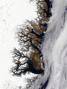
Wollaston Foreland is a peninsula in King Christian X Land, East Greenland. Administratively it belongs to the NE Greenland National Park area.

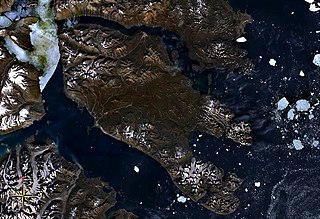
Kuhn Island is a coastal island in Hochstetter Bay, eastern Greenland. There are coal deposits on the island.
Hochstetter Bay is a broad bay in northeastern Greenland. It is part of the Northeast Greenland National Park area.

Zackenberg, or Zackenberg Research Station, is an ecosystem research station and monitoring facility situated in the Northeast Greenland National Park in northeastern Greenland. The station is owned by the Greenland Self-Government and was run by the Danish Arctic Institute until 2008. In 2009 the running of the Station was transferred to the Dept of Arctic Environment at the Danish National Environmental Research Institute
Gael Hamke Bay is a large bay in King Christian X Land, East Greenland. Administratively it is part of the Northeast Greenland National Park zone.

King Christian X Land is an area of northeastern Greenland.

Kangerlussuaq Fjord is a fjord in eastern Greenland. It is part of the Sermersooq municipality.
Newman Bay or Newman Fjord is a fjord in northern Greenland. To the northwest, the fjord opens into the Robeson Channel of the Lincoln Sea. It is a part of the Northeast Greenland National Park.

The Antarctic Sound is a sound in King Christian X Land, Northeast Greenland. Administratively it is part of the Northeast Greenland National Park zone.

Nordvestfjord, meaning 'Northwest Fjord', is a fjord in King Christian X Land, eastern Greenland.

Ofjord is a fjord in King Christian X Land, eastern Greenland. This fjord is part of the Scoresby Sound system. Administratively it lies in the area of Sermersooq municipality.

The Dijmphna Sound is a sound in King Frederick VIII Land, Northeast Greenland. Administratively it is part of the Northeast Greenland National Park zone.
Peters Bay is a bay of the Greenland Sea in King Christian X Land, Greenland. Administratively it belongs to the NE Greenland National Park area.
The Davy Sound is a sound in King Christian X Land, Northeast Greenland. Administratively it is part of the Northeast Greenland National Park zone.
Godthab Gulf, also known as Godthaab Golf, Clavering Fjord, Clavering Sound and Inner Bay, is a fjord in King Christian X Land, East Greenland. Administratively it is part of the Northeast Greenland National Park zone.
Lindeman Fjord is a fjord in King Christian X Land, East Greenland. Administratively it is part of the Northeast Greenland National Park zone.
Tyrolerfjord is a fjord in King Christian X Land, East Greenland. Administratively it is part of the Northeast Greenland National Park zone.
Grandjean Fjord is a fjord in King Christian X Land, East Greenland. Administratively it is part of the Northeast Greenland National Park zone.