
The Berwyn range is an isolated and sparsely populated area of moorland in the northeast of Wales, roughly bounded by Llangollen in the northeast, Corwen in the northwest, Bala in the southwest, and Oswestry in the southeast.
Carnedd Dafydd is a mountain peak in the Carneddau range in Snowdonia, Wales, and is the third highest peak in Wales, or the fourth if Crib y Ddysgl on the Snowdon ridge is counted. Situated south-west of Carnedd Llewelyn and north of Pen yr Ole Wen, Carnedd Dafydd is on the main ridge of the Carneddau, and on the border between Gwynedd and Conwy. The average annual temperature of the mountain is around 3–4 °C (37–39 °F).

Heart North Wales Coast was an independent local radio station broadcast along the North Wales coast, and owned & operated by Global Radio.

Ysgafell Wen is a subsidiary summit of Allt-fawr in Snowdonia, North Wales. It is the highest point on a broad ridge that stretches to the north-west of Moel Druman, and includes two other summits, Ysgafell Wen North Top. and Ysgafell Wen Far North Top.

The Moelwynion are a group of mountains in central Snowdonia, north Wales. They extend from the north-east of Porthmadog to Moel Siabod, the highest of the group. The name derives from the names of two of the largest mountains in the group, Moelwyn Mawr and Moelwyn Bach, 770m and 710m, respectively. Moel Siabod, to the north, is the highest at 872m.
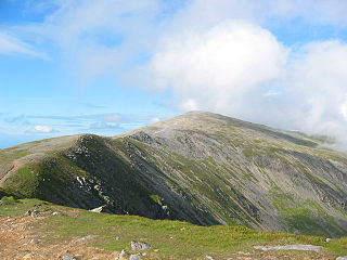
Foel Wen is a subsidiary summit of Cadair Berwyn in north east Wales. It is one of the summits found on the most easterly of Cadair Berwyn's long south ridges.

Sychnant Pass in Conwy County Borough, Wales, links Conwy to Penmaenmawr via Dwygyfylchi. Much of the pass is in Snowdonia National Park, and a large area of land within it has been designated a Site of Special Scientific Interest. At the bottom is the village of Capelulo, which lends its name to the community of Penmaenmawr.

The Afon Lledr is a river in north-west Wales and the second major tributary of the River Conwy. It is about 10 miles or 16 km long, and flows in a generally easterly direction.
Emmett Hill Meadows is a 5.1 hectare biological Site of Special Scientific Interest in Wiltshire, notified in 1987.
The Afon Crafnant is a tributary of the River Conwy, which is the main river of the Conwy valley in north-west Wales.

Tomle is a top of Cadair Berwyn in north east Wales. It is the highest of the summits found on the most easterly of Cadair Berwyn's long south ridges.

Carnedd y Ddelw is a summit in the Carneddau mountains in north Wales, north-east of Foel-fras. It is the Nuttall top of Drum (Wales). Its eastern slopes are drained by the Afon Tafolog, a tributary of Afon Roe that flows through the village of Rowen before joining the River Conwy. It is also the final top on Carnedd Llewelyn's long northern spur. To the north-west is Tal y Fan, the most northerly 2000 foot tall mountain in the Carneddau and Wales. The summit has two large shelter cairns, hollowed out from a large Bronze Age burial cairn.

Ysgafell Wen North Top is a peak on a ridge in Snowdonia, North Wales. It lies to the north of the highest summit on the ridge Ysgafell Wen. It is a subsidiary summit of Allt-fawr. The summit is located at the edge of Cwm Edno, an edge that falls steeply into the cwm.

Cnicht North Top is a top of Cnicht in Snowdonia, which forms part of the Moelwynion mountain range.
Storws Wen Golf Club is a golf course in Brynteg, Benllech, Wales, on the Isle of Anglesey.

Y Ro Wen is a mountain just north of Blaenau Ffestiniog, North Wales and forms part of the Moelwynion.

Y Gamallt is a mountain located in the Migneint in Snowdonia, North Wales. It forms part of the Arenig mountain range being separated from the Moelwynion range at the head of Cwm Teigl.

Cadair Ifan Goch is a crag located above the Conwy Valley in North Wales in the community of Llanddoged and Maenan, and owned by the National Trust. The views extend across the whole of the valley to the Carneddau mountains, and even as far south as the Arenig mountains. The summit of the hill, a bit further up from the crag, reaches 207 metres (679 ft) above sea level.
Llannerch was a commote in the cantref of Dyffryn Clwyd which later became the Marcher Lordship of Ruthin. Situated in an area south of Ruthin the commote covered an area of 9,000 acres which included the parishes of Llanfair Dyffryn Clwyd and Llanelidan and 19 townships. Much of the land within the commote was owned by the Bishopric of Bangor.
