
Snowdon, or Yr Wyddfa, is a mountain in the Snowdonia region of North Wales. It has an elevation of 1,085 metres (3,560 ft) above sea level, which makes it both the highest mountain in Wales and the highest in the British Isles south of the Scottish Highlands. Snowdon is designated a national nature reserve for its rare flora and fauna, and is located within Snowdonia National Park.

The Berwyn range is an isolated and sparsely populated area of moorland in the northeast of Wales, roughly bounded by Llangollen in the northeast, Corwen in the northwest, Bala in the southwest, and Oswestry in the southeast.

Garnedd Ugain, often referred to as Crib-y-Ddysgl, is a pyramidal mountain in Wales that forms part of the Snowdon Massif. It is the second-highest peak in Wales, and lies just under one kilometre north of the summit of Snowdon itself.

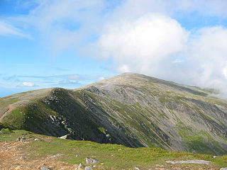
Carnedd Llewelyn, also spelled Carnedd Llywelyn, is a mountain massif in the Carneddau range in Snowdonia, north-west Wales. It is the highest point of the Carneddau and the second highest peak by relative height in Wales, 49th in the British Isles and lies on the border between Gwynedd and Conwy.

Elidir Fawr is a mountain in Snowdonia, north Wales, the northernmost peak in the Glyderau. Its name means 'Big Elidir', named after a legendary warrior king of the 6th century also known as Eliffer Gosgorddfawr.
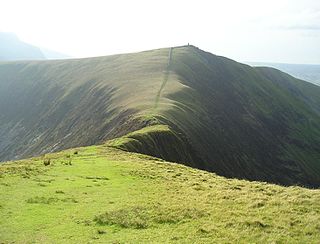
Cadair Berwyn, Cader Berwyn or Craig Uchaf is a mountain summit in north-east Wales with a height of 832 metres (2,730 ft) above sea level. It is the highest point in the Berwyn range, the highest in North East Wales and the highest significant summit in Wales outside the National Parks. Cadair Berwyn and Foel Cedig to the west are the two Marilyns that form the Berwyn range. The undulating plateau of the range also includes a large number of other summits above 2,000 feet (610 m), including satellite summits of Cadair Berwyn and many which are classed as Nuttalls.
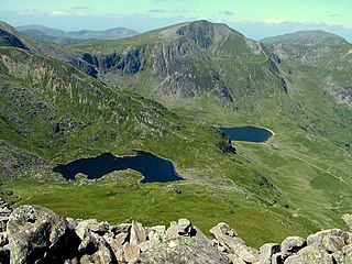
Y Garn is a mountain in Snowdonia, North Wales, part of the Glyderau.
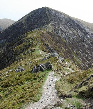
Carnedd Dafydd is a mountain peak in the Carneddau range in Snowdonia, Wales, and is the third highest peak in Wales, or the fourth if Crib y Ddysgl on the Snowdon ridge is counted. Situated south-west of Carnedd Llewelyn and north of Pen yr Ole Wen, Carnedd Dafydd is on the main ridge of the Carneddau, and on the border between Gwynedd and Conwy. The average annual temperature of the mountain is around 3–4 °C.
Pen yr Helgi Du is a mountain peak in the eastern part of the Carneddau in Snowdonia, North Wales.

Ysgafell Wen is a subsidiary summit of Allt-fawr in Snowdonia, North Wales. It is the highest point on a broad ridge that stretches to the north-west of Moel Druman, and includes two other summits, Ysgafell Wen North Top. and Ysgafell Wen Far North Top.

The Moelwynion are a group of mountains in central Snowdonia, north Wales. They extend from the north-east of Porthmadog to Moel Siabod, the highest of the group. The name derives from the names of two of the largest mountains in the group, Moelwyn Mawr and Moelwyn Bach, 770m and 710m, respectively. Moel Siabod, to the north, is the highest at 872m.

Fan Brycheiniog is the highest peak at a height of 802.5 metres (2,633 ft) in the Black Mountain region of the Brecon Beacons National Park in southern Wales. There is a trig point at the peak and on the edge of the escarpment, and nearby, a stone shelter with an inner seat. It lies just inside the historic county of Brecknockshire which gives the mountain its Welsh name. A subsidiary top, less than a kilometre from the summit along the ridge to the northwest, is the highest point of the neighbouring county of Carmarthenshire. Fan Brycheiniog is also within the Fforest Fawr Geopark designated in 2005 in recognition of the area's geological heritage. The views of the moorland and open country to the north are spectacular when the weather is clear, and reveals the isolation of the range, especially when compared with the more popular Pen y Fan range to the east.

Corn Du is a summit of the twin topped Pen y Fan and the second highest peak in South Wales at 871.5 m (2,864 ft), situated in the Brecon Beacons National Park. The summit itself is marked by a well structured Bronze Age cairn with a central burial cist like that on nearby Pen y Fan. The two summits are visible from great distances owing to their height above the surrounding moorland, and are famous landmarks. The views from the peaks are also panoramic and very extensive, the Black Mountain and Fforest Fawr being especially obvious to the west. Mynydd Epynt is visible to the north behind the county town of Brecon, and other parts of the escarpment to the east.

Trum y Ddysgl is a mountain in Snowdonia, north Wales and is the second highest summit on the celebrated Nantlle Ridge. It is also one half of the two Marilyns that make up the ridge, the other being Craig Cwm Silyn.

Moel Lefn is a summit in Snowdonia. It is a subsidiary peak of Moel Hebog and a sister peak of Moel yr Ogof. Its summit marks the end of the Hebog ridge.

Garnedd Goch is a top of Craig Cwm Silyn in Snowdonia, north Wales. It is one of the peaks that forms the Nantlle Ridge. It is the third highest point.
Mynydd Tal-y-Mignedd is a peak on the Nantlle Ridge in Snowdonia, north Wales. It is located at the centre of the ridge, and is a subsidiary summit of Trum y Ddysgl.

Cnicht North Top is a top of Cnicht in Snowdonia, which forms part of the Moelwynion mountain range.
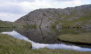
Ysgafell Wen Far North Top is a top of Ysgafell Wen North Top in Snowdonia, North Wales. It lies directly to the west of Ysgafell Wen North Top, and rises as a rocky outcrop from one of the dog lakes, Llynnau'r Cwn.

Y Gamallt is a mountain located in the Migneint in Snowdonia, North Wales. It forms part of the Arenig mountain range being separated from the Moelwynion range at the head of Cwm Teigl.
