Snowdonia, or Eryri, is a mountainous region and national park in North Wales. It contains all 15 mountains in Wales over 3000 feet high, including the country's highest, Snowdon, which is 1,085 metres (3,560 ft) tall. These peaks are all part of the Snowdon, Glyderau, and Carneddau ranges in the north of the region. The shorter Moelwynion and Moel Hebog ranges lie immediately to the south.

Blaenau Ffestiniog is a town in Gwynedd, Wales. Once a slate mining centre in historic Merionethshire, it now relies much on tourists, drawn for instance to the Ffestiniog Railway and Llechwedd Slate Caverns. It reached a population of 12,000 at the peak development of the slate industry, but fell with the decline in demand for slate. The population of the community, including the nearby village Llan Ffestiniog, was 4,875 at the 2011 census: the fourth most populous in Gwynedd after Bangor, Caernarfon and Llandeiniolen. The population not including Llan is now only about 4,000.

Aberllefenni quarry is the collective name of three slate quarries, Foel Grochan, Hen Gloddfa and Ceunant Ddu, located in Cwm Hengae, just to the west of Aberllefenni, Gwynedd, North Wales. It was the longest continually operated slate mine in the world until its closure in 2003. Foel Grochan is the quarry on the north side of the valley, facing Ceunant Ddu and Hen Gloddfa on the south; all three were worked as a single concern throughout their history. Rock was mainly extracted underground, though all three quarries had open pits as well.

Moelwyn Mawr is a mountain in Snowdonia, North Wales and forms part of the Moelwynion. Its summit overlooks the Vale of Ffestiniog and has views in all directions.

Maentwrog is a village and community in the Welsh county of Merionethshire, lying in the Vale of Ffestiniog just below Blaenau Ffestiniog, within the Snowdonia National Park. The River Dwyryd runs alongside the village. Its population of 585 in 2001 increased to 631 at the 2011 Census. The Community of Maentwrog includes the village of Gellilydan.

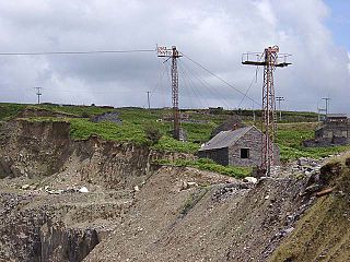
Llechwedd is a visitor attraction near Blaenau Ffestiniog, Gwynedd, Wales. It details the history of slate quarrying in the town and specifically the Llechwedd quarry in which it is located. The main aspect of Llechwedd is its Llechwedd Deep Mine Tour which has the steepest narrow gauge railway in the UK and travels over 500 feet underground to the disused slate caverns, and the Quarry Explorer Tour which heads out to the furthest reaches of the Llechwedd site to explore the history of mining in the area.
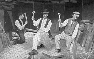
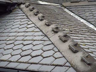
The existence of a slate industry in Wales is attested since the Roman period, when slate was used to roof the fort at Segontium, now Caernarfon. The slate industry grew slowly until the early 18th century, then rapidly during the Industrial Revolution in Wales until the late 19th century, at which time the most important slate producing areas were in northwest Wales. These sites included the Penrhyn Quarry near Bethesda, the Dinorwic Quarry near Llanberis, the Nantlle Valley quarries, and Blaenau Ffestiniog, where the slate was mined rather than quarried. Penrhyn and Dinorwig were the two largest slate quarries in the world, and the Oakeley mine at Blaenau Ffestiniog was the largest slate mine in the world. Slate is mainly used for roofing, but is also produced as thicker slab for a variety of uses including flooring, worktops and headstones.
Pen-yr-Orsedd quarry was a slate quarry in the Nantlle Valley in North Wales. It was one of the last slate quarries operating in North Wales and the last operating in the Nantlle Valley area, finally closing in 1979.

Plas Tan y Bwlch in Gwynedd, Wales, is the Snowdonia National Park environmental studies centre, administered by the National Park Authority. It is located approximately 6 miles (9.7 km) east of the coastal town of Porthmadog, overlooking the valley of the River Dwyryd and the village of Maentwrog.

Mining in Wales provided a significant source of income to the economy of Wales throughout the nineteenth century and early to mid twentieth century. It was key to the Industrial Revolution in Wales, and to the whole of Great Britain.

Oakeley quarry is a slate quarry in the town of Blaenau Ffestiniog, north Wales. It was the largest underground slate mine in the world, and had 26 floors spanning a vertical height of nearly 1,500 feet (460 m).

Conglog quarry was a small enterprise situated to the north-west of Tanygrisiau, near Blaenau Ffestiniog in Wales. It was overshadowed by the much bigger Rhosydd quarry a little further to the west. It was active from 1854 to 1910, and was operated by an individual, two partnerships and four separate companies over this period.

Rhiwbach quarry was a slate quarry located to the east of Blaenau Ffestiniog in North Wales. The quarry was a remote site; it was nearly 4 miles (6.4 km) to north-east of Duffws, the Festiniog Railway's terminus in Blaenau Ffestiniog. It was the connected to the Ffestiniog Railway by the Rhiwbach Tramway. Commercial operation began around 1812, and it finally closed in 1952. It was the last Welsh slate quarry where workers lived in barracks on the site. 'Rhiwbach' is Welsh for 'Little Hill'.

Cwmorthin quarry was a slate quarry west of the village of Tanygrisiau, north Wales. Quarrying on the site started in 1810. In 1860 it was connected to the Ffestiniog Railway. In 1900 it was acquired by the nearby Oakeley quarry and the two were connected underground. In 1970 it closed along with Oakeley. There was small-scale working in the 1980s and 1990s, and the mine finally closed in 1997.
Votty & Bowydd quarry is a major slate quarry in the town of Blaenau Ffestiniog, North Wales. It was one of the major users of the Ffestiniog Railway. It opened in 1870 In the quarry's peak years around 1900, the quarry produced around 17,000 tons-per-annum of slate, employing 500 men. It continues to produce crushed slate on a limited scale under the ownership of the nearby Llechwedd quarry.

Nyth-y-Gigfran quarry was a slate quarry in the town of Blaenau Ffestiniog, North Wales. It was located about 300 feet (91 m) above the settlement of Glan y Pwll, south of what was to become Blaenau Ffestiniog. The quarry was sited on the steep cliffs that form the eastern edge of Allt-fawr and was entirely underground. The quarry opened around 1840 and became part of the Oakeley quarry in the 1880s; this in turn closed in 1969.
The Cwmorthin Tramway was a 1 ft 11+1⁄2 in industrial tramway in North Wales, which connected the Ffestiniog Railway to the Cwmorthin Quarry and later the Conglog Slate Quarry. It was built in the 1840s or 1850s, rising through two inclined planes to reach the main Cwmorthin Quarry mill and its internal incline which rose from floor 1 to floor 8. In 1874, it was extended, rising up through a third incline to the Cwmorthin Lake level and continuing along the valley floor to reach the Conglog Quarry. The tracks to Conglog were abandoned in the 1920s and the rest of the tramway ceased to be used from the onset of the Second World War.
Parc Quarry was a compact underground slate quarry in the Croesor Valley, Gwynedd, North Wales. It was connected to the Croesor Tramway, which ran through the valley. The quarry concentrated on producing specialist slate products, rather than roofing slates, and was managed for much of the time by the innovator Moses Kellow. It operated for about 50 years, from 1870 to 1920.

Gloddfa Ganol was a museum dedicated to the Welsh slate industry and narrow-gauge railways, situated in the Oakeley slate quarry in Blaenau Ffestiniog. It opened in 1974 and closed in 1998 following an auction of its exhibits.