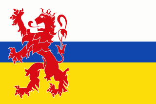
Limburg is the southernmost of the 12 provinces of the Netherlands. The province is bordered by the province of Gelderland to the north and by North Brabant to its west. Its long eastern boundary forms the international border with the state of North Rhine-Westphalia in Germany. To the west is the international border with the similarly named Belgian province of Limburg, part of which is delineated by the river Meuse. The Vaalserberg is on the extreme south-eastern point, marking the tripoint of the Netherlands, Germany and Belgium.

America is a parish village in the Dutch province of Limburg, known historically for its peat extraction.

Kerkrade is a town and a municipality in the southeast of Limburg; the southernmost province of the Netherlands. It forms part of the Parkstad Limburg agglomeration.

Roermond is a city, municipality, and diocese in the Limburg province of the Netherlands. Roermond is a historically important town on the lower Roer on the east bank of the river Meuse. It received town rights in 1231. Roermond's town centre has become a designated conservation area.

Venray or Venraij is a municipality and a city in Limburg, the Netherlands.

Elsloo is a village in the Dutch province of Limburg. It is located in the municipality of Stein, about 2 km south of the town of Stein itself. Beek-Elsloo railway station serves Elsloo.

Goor is a city about 20 km west of Enschede in the Dutch province of Overijssel. It received city rights in 1263.

Wessem is a small city in the Netherlands, in the province of Limburg. Wessem is a part of the municipality of Maasgouw. It received city rights around 1320.

Blitterswijck is a village in the Dutch province of Limburg. It is a part of the municipality of Venray, and lies about 20 km north of Venlo.

Horn is a village in the Dutch province of Limburg. It is a part of the municipality of Leudal, and lies about 5 km northwest of Roermond.

The Dutch resistance to the Nazi occupation of the Netherlands during World War II can be mainly characterized as non-violent. The primary organizers were the Communist Party, churches, and independent groups. Over 300,000 people were hidden from German authorities in the autumn of 1944 by 60,000 to 200,000 illegal landlords and caretakers. These activities were tolerated knowingly by some one million people, including a few individuals among German occupiers and military.

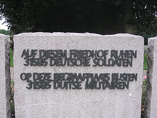
Ysselsteyn German War Cemetery is a military cemetery interring casualties of the First and Second World Wars. It contains over 31,000 soldiers from around 25 countries, including SS-men and Dutch war criminals. This cemetery is located in the village of Ysselsteyn in the municipality of Venray in Limburg, Netherlands, and is 32 km (20 mi) east of Eindhoven. Ysselsteyn is the largest Second World War German cemetery and is the only Nazi-German cemetery in the Netherlands. Following the war, the Nazi soldiers were reburied in the cemetery. The deceased include Germans, Dutch, Poles, and Russians who fought on the side of the Nazis.

Mesch is a village in the Dutch province of Limburg. It is located in the municipality of Eijsden-Margraten, quite near to the Netherlands' the southerly border with Belgium, on the other side of which the neighbouring village of Moelingen is situated. In its northwest, Mesch borders the larger village of Eijsden, whereas the city and municipality of Maastricht lies about 10 km farther to the north. The relatively small Voer river, which has its source in Belgium, passes through this village among other streams and waterways, before draining into the Meuse river at Eijsden. The Mergellandroute, a route often used by tourists and mapped out by the ANWB, also passes through Mesch.

Urmond is a village in the Dutch province of Limburg. It is located in the municipality of Stein.

Vaesrade is a village in the Dutch province of Limburg. It is located in the municipality of Beekdaelen.

Wanssum is a village in the Dutch province of Limburg. It is located in the municipality of Venray.
During World War II, the Netherlands was the scene of five years of continuous air warfare between the Allied and the Nazis as the Netherlands lies en route from England to Germany and was designated and built up as the foremost line of Nazi air defence of Germany. Also, in 1944 there was heavy land fighting during the largest Allied airborne attack of the WWII in the south and east of the country in 1944–45. Thousands of airmen, soldiers and others of many nations were killed, and their war graves in some 4,000 locations are in the care of the Dutch War Cemetery Organisation.

Grebbeberg War Cemetery is a Second World War military war grave cemetery, located on the Grebbeberg, a hill 2 km (1.2 mi) east of Rhenen the Netherlands. The cemetery contains 799 military personnel and one civilian who died during the invasion of the Netherlands by the Germans in May 1940. More than 400 of those interred in the cemetery fell during the Battle of the Grebbeberg.

Nijswiller is a village in the southern part of the Dutch province of Limburg. It is a part of the municipality of Gulpen-Wittem, and is located about 19 kilometres (12 mi) east of Maastricht.


