Ząbin

Last updated
Ząbin
Village
Country Flag of Poland.svg  Poland
Voivodeship Kuyavian-Pomeranian
County Włocławek County
Gmina Choceń

Ząbin [ˈzɔmbin] (German : Sommen) is a village in the administrative district of Gmina Choceń, within Włocławek County, Kuyavian-Pomeranian Voivodeship, in north-central Poland. [1]

German language West Germanic language

German is a West Germanic language that is mainly spoken in Central Europe. It is the most widely spoken and official or co-official language in Germany, Austria, Switzerland, South Tyrol (Italy), the German-speaking Community of Belgium, and Liechtenstein. It is also one of the three official languages of Luxembourg and a co-official language in the Opole Voivodeship in Poland. The languages which are most similar to German are the other members of the West Germanic language branch: Afrikaans, Dutch, English, the Frisian languages, Low German/Low Saxon, Luxembourgish, and Yiddish. There are also strong similarities in vocabulary with Danish, Norwegian and Swedish, although those belong to the North Germanic group. German is the second most widely spoken Germanic language, after English.

Gmina Choceń is a rural gmina in Włocławek County, Kuyavian-Pomeranian Voivodeship, in north-central Poland. Its seat is the village of Choceń, which lies approximately 19 kilometres (12 mi) south of Włocławek and 67 km (42 mi) south-east of Toruń.

Włocławek County County in Kuyavian-Pomeranian, Poland

Włocławek County is a unit of territorial administration and local government (powiat) in Kuyavian-Pomeranian Voivodeship, north-central Poland. It came into being on January 1, 1999, as a result of the Polish local government reforms passed in 1998. Its administrative seat is the city of Włocławek, although the city is not part of the county. The county contains six towns: Brześć Kujawski, which lies 12 km (7 mi) south-west of Włocławek, Kowal, which lies 15 km (9 mi) south-east of Włocławek, Lubraniec, which lies 19 km (12 mi) south-west of Włocławek, Izbica Kujawska, which lies 33 km (21 mi) south-west of Włocławek, Chodecz, which lies 28 km (17 mi) south of Włocławek, and Lubień Kujawski, 29 km (18 mi) south of Włocławek.

Related Research Articles

North Thompson Oxbows East Provincial Park is a provincial park in British Columbia, Canada.

Kurabalakota Village in Andhra Pradesh, India

Kurabalakota is a census town in Chittoor district of the Indian state of Andhra Pradesh. It is a mandal headquarters of Thamballapalle Constituency.

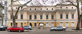
Odessa Pushkin Museum

Odessa Pushkin Museum is a museum dedicated to the Russian poet Alexander Pushkin in Odessa, Ukraine.

Stare Wykno is a village in the administrative district of Gmina Kulesze Kościelne, within Wysokie Mazowieckie County, Podlaskie Voivodeship, in north-eastern Poland.

Klapka is a village in the administrative district of Gmina Biała, within Wieluń County, Łódź Voivodeship, in central Poland.

Gorzewo is a village in the administrative district of Gmina Gostynin, within Gostynin County, Masovian Voivodeship, in east-central Poland.

Nowa Jastrzębia is a village in the administrative district of Gmina Gostynin, within Gostynin County, Masovian Voivodeship, in east-central Poland.

Piribeg is a mountain peak located between Kosovo and the Republic of Macedonia. Piribeg reaches a height of 2,524 meters above sea level, and is a peak of the eastern part of the Šar Mountains.

Svendborgbanen

Svendborgbanen is the Danish railway line between Odense and Svendborg. The line was opened on 12 July 1876.

Orłowo, Giżycko County Village in Warmian-Masurian, Poland

Orłowo is a village in the administrative district of Gmina Wydminy, within Giżycko County, Warmian-Masurian Voivodeship, in northern Poland. It lies approximately 11 kilometres (7 mi) north-east of Wydminy, 26 km (16 mi) east of Giżycko, and 113 km (70 mi) east of the regional capital Olsztyn.

Izumma Station railway station in Hamamatsu, Shizuoka prefecture, Japan

Izumma Station is a railway station on the Iida Line in Tenryū-ku, Hamamatsu, Shizuoka Prefecture, Japan. It is located 55.4 rail kilometers from the southern terminus of the Iida Line at Toyohashi Station.

Drumraney is a village in the County Westmeath, Ireland, just off the R390 regional road between Athlone and Mullingar. It is part of a small parish with a population of approximately 242 which includes the nearby village of Tang. It is approximately 12 km from Athlone.

Toklucak is a village in the District of Emirdağ, Afyonkarahisar Province, Turkey.

St. Philip's Parish Library, also known as the Higgs Library, was a public library attached to St Philip's Church in Birmingham, England between 1733 and 1927.

Marijan is a village in Behrestagh Rural District, in the Central District of Amol County, Mazandaran Province, Iran. At the 2006 census, its population was 28, in 7 families.

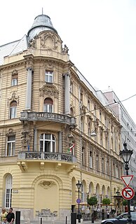
Danube Palace

The Danube Palace is a Neo-Baroque concert hall located in the Inner City of Budapest, Hungary. It was built between 1883 and 1885 according to the plans of Vilmos Freund. It was known as the casino of Lipótváros – not in the sense of gambling - but an aristocratic club for entertainment. The Palace served as a place of culture, supporting many young artists. Bartók, Kodály, and Dvorák all played in its first-class concert hall. Since 1951 the building has been carrying out the cultural programs of the Ministry of Internal Affairs. It is home to the Danube Symphony Orchestra.

Deutsche Schule Valencia school

The Deutsche Schule Valencia is a German international school in Valencia, Spain. It serves preschool through senior high school levels.

Selišta is a village in Pljevlja Municipality, in northern Montenegro. According to the 2003 census, the village had a population of 20 people.

Battle of Bosra (2015)

The Battle of Bosra refers to a military operation launched by Syrian rebels during the Syrian Civil War, in order to capture the city of Bosra.

Ghoufi canyon in Algeria, and adjacent village

Ghoufi is a historic settlement in the Batna Province, Algeria.

References


Coordinates: 52°28′54″N19°02′57″E / 52.4817°N 19.0492°E / 52.4817; 19.0492

Geographic coordinate system Coordinate system

A geographic coordinate system is a coordinate system that enables every location on Earth to be specified by a set of numbers, letters or symbols. The coordinates are often chosen such that one of the numbers represents a vertical position and two or three of the numbers represent a horizontal position; alternatively, a geographic position may be expressed in a combined three-dimensional Cartesian vector. A common choice of coordinates is latitude, longitude and elevation. To specify a location on a plane requires a map projection.