OSiR Skałka is a multi-use stadium in Świętochłowice, Poland. It is currently used mostly for football matches. The stadium has a capacity of 26,000 people.
Zielonka is a town in Wołomin County, Masovian Voivodeship, Poland, with 17,398 inhabitants (2013). It is located about 13 km to the north-east of the centre of Warsaw. City rights since 1960.

Osowa Góra is a village in the administrative district of Gmina Sicienko, within Bydgoszcz County, Kuyavian-Pomeranian Voivodeship, in north-central Poland. It lies 8 kilometres (5 mi) south-east of Sicienko and 9 km (6 mi) north-west of Bydgoszcz.
Ostrowiec is a village in the administrative district of Gmina Wałcz, within Wałcz County, West Pomeranian Voivodeship, in north-western Poland. It lies approximately 6 kilometres (4 mi) north-east of Wałcz and 130 km (81 mi) east of the regional capital Szczecin.

Kożyno is a village in the administrative district of Gmina Bielsk Podlaski, within Bielsk County, Podlaskie Voivodeship, in north-eastern Poland.
Kolonia Nowogrodzka is a village in the administrative district of Gmina Miastkowo, within Łomża County, Podlaskie Voivodeship, in north-eastern Poland.

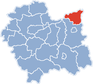
Michałowice is a village in Kraków County, Lesser Poland Voivodeship, in southern Poland. It is the seat of the gmina called Gmina Michałowice. It lies approximately 12 km (7 mi) north of the regional capital Kraków.
Borowina Sitaniecka is a village in the administrative district of Gmina Zamość, within Zamość County, Lublin Voivodeship, in eastern Poland. It lies approximately 7 kilometres (4 mi) north-east of Zamość and 74 km (46 mi) south-east of the regional capital Lublin.
Dębiany is a village in the administrative district of Gmina Wodzisław, within Jędrzejów County, Świętokrzyskie Voivodeship, in south-central Poland. It lies approximately 9 kilometres (6 mi) north-east of Wodzisław, 10 km (6 mi) south of Jędrzejów, and 43 km (27 mi) south-west of the regional capital Kielce.
Dobiecin is a village in the administrative district of Gmina Chynów, within Grójec County, Masovian Voivodeship, in east-central Poland.
Rudno is a village in the administrative district of Gmina Dobre, within Mińsk County, Masovian Voivodeship, in east-central Poland. It lies approximately 4 kilometres (2 mi) south-east of Dobre, 17 km (11 mi) north-east of Mińsk Mazowiecki, and 50 km (31 mi) east of Warsaw.
Wilcze Tułowskie is a village in the administrative district of Gmina Brochów, within Sochaczew County, Masovian Voivodeship, in east-central Poland.
Dębowiczki is a village in the administrative district of Gmina Olszówka, within Koło County, Greater Poland Voivodeship, in west-central Poland.
Dominice is a village in the administrative district of Gmina Włoszakowice, within Leszno County, Greater Poland Voivodeship, in west-central Poland. It lies approximately 5 kilometres (3 mi) west of Włoszakowice, 21 km (13 mi) north-west of Leszno, and 67 km (42 mi) south-west of the regional capital Poznań.
Chruściki is a village in the administrative district of Gmina Zagórów, within Słupca County, Greater Poland Voivodeship, in west-central Poland. It lies approximately 8 kilometres (5 mi) east of Zagórów, 18 km (11 mi) south-east of Słupca, and 79 km (49 mi) east of the regional capital Poznań.
Kaszczor is a village in the administrative district of Gmina Przemęt, within Wolsztyn County, Greater Poland Voivodeship, in west-central Poland. It lies approximately 12 kilometres (7 mi) south-west of Przemęt, 18 km (11 mi) south of Wolsztyn, and 71 km (44 mi) south-west of the regional capital Poznań.
Miodnica is a village in the administrative district of Gmina Żagań, within Żagań County, Lubusz Voivodeship, in western Poland.

Moszczanka is a village in the administrative district of Gmina Prudnik, within Prudnik County, Opole Voivodeship, in south-western Poland, close to the Czech border. It lies approximately 7 kilometres (4 mi) west of Prudnik and 52 km (32 mi) south-west of the regional capital Opole.
Litewki is a settlement in the administrative district of Gmina Dzierzgoń, within Sztum County, Pomeranian Voivodeship, in northern Poland.
Drawa is a village in the administrative district of Gmina Bartoszyce, within Bartoszyce County, Warmian-Masurian Voivodeship, in northern Poland, close to the border with the Kaliningrad Oblast of Russia.