Zachód, Szczecin

Last updated
Zachód
District
College of Zachod district, Szczecin.png
CountryFlag of Poland.svg  Poland
Voivodeship West Pomeranian
County/City Szczecin
Population (2011)
  Total 116,232
Time zone CET (UTC+1)
  Summer (DST) CEST (UTC+2)
Area code(s) +48 91
Car plates ZS
Districts of Szczecin:
Srodmiescie
Zachod
Polnoc
Prawobrzeze Szczecin quarters 2010-05.png
Districts of Szczecin:
  Zachód
   Północ

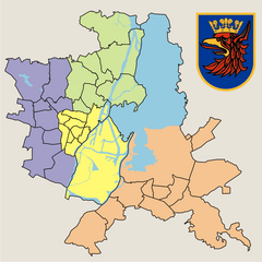
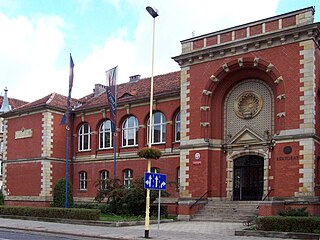
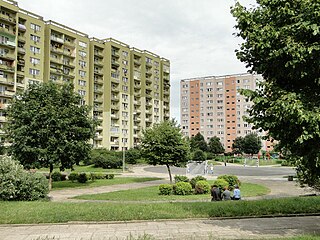
Zachód (lit. West) is one of four districts (Polish: dzielnica) of Szczecin, Poland situated on the left bank of Oder river in western part of the city. As of January 2011 it had a population of 116,232. [1]

In the Polish system of local administration, a dzielnica is an administrative subdivision or quarter of a city or town. A dzielnica may have its own elected council, and those of Warsaw each have their own mayor (burmistrz). Like the osiedle and sołectwo, a dzielnica is an auxiliary unit of a gmina. These units are created by decision of the gmina council, and do not have legal personality in their own right.

Szczecin Place in West Pomeranian, Poland

Szczecin is the capital and largest city of the West Pomeranian Voivodeship in Poland. Located near the Baltic Sea and the German border, it is a major seaport and Poland's seventh-largest city. As of June 2018, the population was 403,274.

Poland republic in Central Europe

Poland, officially the Republic of Poland, is a country located in Central Europe. It is divided into 16 administrative subdivisions, covering an area of 312,696 square kilometres (120,733 sq mi), and has a largely temperate seasonal climate. With a population of approximately 38.5 million people, Poland is the sixth most populous member state of the European Union. Poland's capital and largest metropolis is Warsaw. Other major cities include Kraków, Łódź, Wrocław, Poznań, Gdańsk, and Szczecin.

Zachód is divided into 9 municipal neighbourhoods:

Arkońskie-Niemierzyn Municipal neighbourhood in Szczecin, West Pomeranian, Poland

Arkońskie-Niemierzyn is a municipal neighbourhood of the city of Szczecin, Poland situated on the left bank of Oder river, north-west of the Szczecin Old Town, in Zachód (West) District. As of January 2011 it had a population of 11,533.

Głębokie-Pilchowo Municipal neighbourhood in Szczecin, West Pomeranian, Poland

Głębokie-Pilchowo is a municipal neighbourhood of the city of Szczecin, Poland situated on the left bank of Oder river, north-west of the Szczecin Old Town, in Zachód (West) District. As of January 2011 it had a population of 1,216.

Gumieńce Municipal neighbourhood in Szczecin, West Pomeranian, Poland

Gumieńce is a municipal neighbourhood of the city of Szczecin, Poland situated on the left bank of Oder river, west of the Szczecin Old Town, Middle Town and Pomorzany. As of January 2011 it had a population of 19,120.

Related Research Articles

Szczecin Voivodeship former voivodeship in Poland (1975–1998)

Szczecin Voivodeship (1) was a unit of administrative division and local government in Poland in the years 1975–1998, superseded by West Pomeranian Voivodeship.


Śródmieście, Szczecin District in West Pomeranian, Poland

Śródmieście is one of four districts of Szczecin, Poland situated in central part of the city. As of March 2015 it had a population of 118 702.

Krzekowo-Bezrzecze Municipal neighbourhood in Szczecin, West Pomeranian, Poland

Krzekowo-Bezrzecze is a municipal neighbourhood of the city of Szczecin, Poland situated on the left bank of Oder river, west of the Szczecin Old Town and Middle Town, in Zachód (West) District. As of January 2011 it had a population of 3,644.

Świerczewo, Szczecin Municipal neighbourhood in Szczecin, West Pomeranian, Poland

Świerczewo is a municipal neighborhood of the city of Szczecin, Poland situated on the left bank of Oder river, west of the Szczecin Old Town and Middle Town, in Zachód (West) District. As of January 2011 it had a population of 16,860.

Osów, Szczecin Municipal neighbourhood in Szczecin, West Pomeranian, Poland

Osów is a municipal neighbourhood of the city of Szczecin, Poland situated on the left bank of Oder river, north-west of the Szczecin Old Town and Middle Town, in Zachód (West) District. As of January 2011 it had a population of 3,417.

Szczecin University of Technology

Szczecin University of Technology was one of the biggest universities in Szczecin, Poland.

A6 autostrada (Poland) Motorway in Poland

The autostrada A6 in Poland is a 25.7 km (16.0 mi) long motorway that starts at the Polish/German border at Kołbaskowo/Pomellen connecting to the German A11 autobahn. It forms a southern bypass of the Szczecin metropolitan area and terminates to the east of the city, where it becomes the S3 express road to Świnoujście. Another 4.9 km (3 mi) of the S3 road will be redesignated as A6, once improvement work is carried out. The motorway is part of the European route E28.

Stadion Florian Krygier football stadium

Stadion Florian Krygier is a multi-use stadium in Szczecin, Poland. It is currently used mostly for football matches and is the home ground of Pogoń Szczecin. The stadium holds 18,027 people and was built in 1925.

Kołbaskowo Village in West Pomeranian, Poland

Kołbaskowo is a village in Police County, West Pomeranian Voivodeship, in north-western Poland, close to the German border. It is the seat of the gmina called Gmina Kołbaskowo. It lies approximately 24 kilometres (15 mi) south of Police and 14 km (9 mi) south-west of the regional capital Szczecin. As of 2006 the village has a population of 410.

Skidlewo is a village in the administrative district of Gmina Janów, within Sokółka County, Podlaskie Voivodeship, in north-eastern Poland.

University of Szczecin

The University of Szczecin is a public university in Szczecin, western Poland. It is the biggest university in West Pomerania, with 33,267 students and a staff of nearly 1,200. It consists of 9 faculties:

  1. Faculty of Humanities
  2. Faculty of Law and Administration
  3. Faculty of Natural Sciences
  4. Faculty of Mathematics and Physics
  5. Faculty of Economics and Management
  6. Faculty of Management and Economics of Services
  7. Faculty of Theology
  8. Faculty of Geosciences
  9. Faculty of Philology
Zawadzkiego-Klonowica Municipal neighbourhood in Szczecin, West Pomeranian, Poland

Zawadzkiego-Klonowica is a municipal neighbourhood of the city of Szczecin, Poland, situated on the left bank of Oder river, in Zachód (West) District. It borders Krzekowo-Bezrzecze to the west, Głębokie-Pilchowo and Osów to the north, Arkońskie-Niemierzyn to the east, and Pogodno to the south. As of January 2011 it had a population of 12,983.

Nowe Miasto, Szczecin Municipal neighbourhood in Szczecin, West Pomeranian, Poland

Nowe Miasto is a municipal neighbourhood of the city of Szczecin, Poland, situated on the left bank of Oder river, in Śródmieście (Centre) District. It borders Turzyn to the west, Śródmieście-Zachód, Centrum and Stare Miasto to the north, Międzyodrze-Wyspa Pucka to the east, and Pomorzany to the south. As of January 2011 it had a population of 8092.

Centrum, Szczecin Municipal neighbourhood in Szczecin, West Pomeranian, Poland

Centrum is a municipal neighbourhood of the city of Szczecin, Poland, situated on the left bank of Oder river, in Śródmieście (Centre) District. It borders Śródmieście-Zachód to the west, Śródmieście-Północ to the north, Stare Miasto to the east, and Nowe Miasto to the south. As of January 2011 it had a population of 21,064.

Północ, Szczecin District in West Pomeranian, Poland

Północ is one of four districts of Szczecin, Poland situated in northern part of the city. As of January 2011 it had a population of 54,004.

Prawobrzeże District in West Pomeranian, Poland

Prawobrzeże is one of four districts of Szczecin, Poland situated on the right bank of Oder river in eastern part of the city. As of January 2011 it had a population of 84,001.

Śródmieście-Zachód Municipal neighbourhood in Szczecin, West Pomeranian, Poland

Śródmieście-Zachód is a municipal neighbourhood of the city of Szczecin, Poland, in Śródmieście (Centre) District. As of January 2011 it had a population of 15,996.

National road 6 (Poland) national road in Poland

National Road 6 is a route belonging to the Polish national roads network. The route is in the north of Poland and runs from the German border, in Kołbaskowo-Nadrensee, to Łęgowo for 351 km. The route runs through the West Pomeranian Voivodeship and the Pomeranian Voivodeship; it is important for transportation between the two largest agglomerations in northern Poland, Szczecin and the Tricity.

References

  1. "Zestawienie informacyjne o liczbie osób zameldowanych w Szczecinie" (in Polish). Urząd Miasta Szczecin. Retrieved 2011-01-23.

Coordinates: 53°26′24″N14°29′50″E / 53.4399°N 14.4972°E / 53.4399; 14.4972

Geographic coordinate system Coordinate system

A geographic coordinate system is a coordinate system that enables every location on Earth to be specified by a set of numbers, letters or symbols. The coordinates are often chosen such that one of the numbers represents a vertical position and two or three of the numbers represent a horizontal position; alternatively, a geographic position may be expressed in a combined three-dimensional Cartesian vector. A common choice of coordinates is latitude, longitude and elevation. To specify a location on a plane requires a map projection.