Ludgeřovice is a village in the Moravian-Silesian Region of the Czech Republic. It is part of Hlučín micro-region. It has around 4,600 inhabitants.

Jaksonowice is a village in the administrative district of Gmina Długołęka, within Wrocław County, Lower Silesian Voivodeship, in south-western Poland. Prior to 1945 it was in Germany.
Surhów-Kolonia is a village in the administrative district of Gmina Kraśniczyn, within Krasnystaw County, Lublin Voivodeship, in eastern Poland.

Podradwanie is a settlement in the administrative district of Gmina Szczucin, within Dąbrowa County, Lesser Poland Voivodeship, in southern Poland. It lies approximately 7 kilometres (4 mi) south of Szczucin, 10 km (6 mi) north-east of Dąbrowa Tarnowska, and 82 km (51 mi) east of the regional capital Kraków.

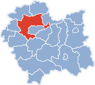
Zagaje Smrokowskie is a village in the administrative district of Gmina Słomniki, within Kraków County, Lesser Poland Voivodeship, in southern Poland. It lies approximately 7 kilometres (4 mi) north-west of Słomniki and 25 km (16 mi) north of the regional capital Kraków.

Zagaje Kikowskie is a village in the administrative district of Gmina Solec-Zdrój, within Busko County, Świętokrzyskie Voivodeship, in south-central Poland. It lies approximately 6 kilometres (4 mi) north of Solec-Zdrój, 13 km (8 mi) south-east of Busko-Zdrój, and 55 km (34 mi) south of the regional capital Kielce.

Zagaje is a village in the administrative district of Gmina Jędrzejów, within Jędrzejów County, Świętokrzyskie Voivodeship, in south-central Poland. It lies approximately 8 kilometres (5 mi) south of Jędrzejów and 41 km (25 mi) south-west of the regional capital Kielce.
Zagaje is a part of village Pawłowice in the administrative district of Gmina Sędziszów, within Jędrzejów County, Świętokrzyskie Voivodeship, in south-central Poland.

Zagaje Stradowskie is a village in the administrative district of Gmina Czarnocin, within Kazimierza County, Świętokrzyskie Voivodeship, in south-central Poland. It lies approximately 6 kilometres (4 mi) north-west of Czarnocin, 13 km (8 mi) north of Kazimierza Wielka, and 57 km (35 mi) south of the regional capital Kielce.

Kobiela is a village in the administrative district of Gmina Opatowiec, within Kazimierza County, Świętokrzyskie Voivodeship, in south-central Poland. It lies approximately 3 kilometres (2 mi) north-west of Opatowiec, 15 km (9 mi) east of Kazimierza Wielka, and 72 km (45 mi) south of the regional capital Kielce.

Bugaj is a village in the administrative district of Gmina Strawczyn, within Kielce County, Świętokrzyskie Voivodeship, in south-central Poland. It lies approximately 7 kilometres (4 mi) east of Strawczyn and 10 km (6 mi) north-west of the regional capital Kielce.

Potok-Kolonia is a village in the administrative district of Gmina Ożarów, within Opatów County, Świętokrzyskie Voivodeship, in south-central Poland. It lies approximately 6 kilometres (4 mi) north of Ożarów, 22 km (14 mi) north-east of Opatów, and 73 km (45 mi) east of the regional capital Kielce.

Chocimów is a village in the administrative district of Gmina Kunów, within Ostrowiec County, Świętokrzyskie Voivodeship, in south-central Poland. It lies approximately 4 kilometres (2 mi) south-west of Kunów, 11 km (7 mi) west of Ostrowiec Świętokrzyski, and 45 km (28 mi) east of the regional capital Kielce.

Zagaje Dębiańskie is a village in the administrative district of Gmina Działoszyce, within Pińczów County, Świętokrzyskie Voivodeship, in south-central Poland. It lies approximately 10 kilometres (6 mi) north-east of Działoszyce, 16 km (10 mi) south of Pińczów, and 55 km (34 mi) south of the regional capital Kielce.
Podlesiec is a village in the administrative district of Gmina Dobiegniew, within Strzelce-Drezdenko County, Lubusz Voivodeship, in western Poland.
Zagaje is a village in the administrative district of Gmina Zwierzyn, within Strzelce-Drezdenko County, Lubusz Voivodeship, in western Poland.

Zagaje is a village in the administrative district of Gmina Lubrza, within Świebodzin County, Lubusz Voivodeship, in western Poland. It lies approximately 4 kilometres (2 mi) north-west of Lubrza, 13 km (8 mi) north-west of Świebodzin, 44 km (27 mi) north of Zielona Góra, and 47 km (29 mi) south of Gorzów Wielkopolski.

Żołna is a village in the administrative district of Gmina Przechlewo, within Człuchów County, Pomeranian Voivodeship, in northern Poland. It lies approximately 12 kilometres (7 mi) north of Przechlewo, 30 km (19 mi) north of Człuchów, and 105 km (65 mi) south-west of the regional capital Gdańsk.

Zagaje is a settlement in the administrative district of Gmina Prabuty, within Kwidzyn County, Pomeranian Voivodeship, in northern Poland. It lies approximately 8 kilometres (5 mi) south of Prabuty, 16 km (10 mi) east of Kwidzyn, and 82 km (51 mi) south-east of the regional capital Gdańsk.
Zagaje is a settlement in the administrative district of Gmina Polanów, within Koszalin County, West Pomeranian Voivodeship, in north-western Poland.


