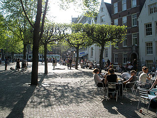
The Spui is a square in the centre of Amsterdam, the capital of the Netherlands. The Spui was originally a body of water that formed the southern limit of the city until the 1420s, when the Singel canal was dug as an outer moat around the city. In 1882 the Spui was filled in and became the square that we know today.
Starogród Dolny is a village in the administrative district of Gmina Chełmno, within Chełmno County, Kuyavian-Pomeranian Voivodeship, in north-central Poland.

Boguszyn is a village in the administrative district of Gmina Wałcz, within Wałcz County, West Pomeranian Voivodeship, in north-western Poland. It lies approximately 15 kilometres (9 mi) north-west of Wałcz and 117 km (73 mi) east of the regional capital Szczecin.
Józefin is a village in the administrative district of Gmina Poświętne, within Białystok County, Podlaskie Voivodeship, in north-eastern Poland.
Krężna-Kolonia is a village in the administrative district of Gmina Wola Krzysztoporska, within Piotrków County, Łódź Voivodeship, in central Poland.
Antoninów is a village in the administrative district of Gmina Biała Rawska, within Rawa County, Łódź Voivodeship, in central Poland. It lies approximately 8 kilometres (5 mi) north-west of Biała Rawska, 16 km (10 mi) north-east of Rawa Mazowiecka, and 67 km (42 mi) east of the regional capital Łódź.
Boczki is a village in the administrative district of Gmina Szadek, within Zduńska Wola County, Łódź Voivodeship, in central Poland. It lies approximately 9 kilometres (6 mi) west of Szadek, 15 km (9 mi) north-west of Zduńska Wola, and 43 km (27 mi) west of the regional capital Łódź.
Zezulin Pierwszy is a village in the administrative district of Gmina Ludwin, within Łęczna County, Lublin Voivodeship, in eastern Poland.
Stajki is a settlement in the administrative district of Gmina Stanin, within Łuków County, Lublin Voivodeship, in eastern Poland. It lies approximately 4 kilometres (2 mi) east of Stanin, 12 km (7 mi) south-west of Łuków, and 71 km (44 mi) north of the regional capital Lublin.
Mierzwice-Kolonia is a village in the administrative district of Gmina Sarnaki, within Łosice County, Masovian Voivodeship, in east-central Poland.
Borkowo Wielkie is a village in the administrative district of Gmina Sierpc, within Sierpc County, Masovian Voivodeship, in east-central Poland. It lies approximately 6 kilometres (4 mi) south-east of Sierpc and 111 km (69 mi) north-west of Warsaw.
Kolonia Paderewek is a village in the administrative district of Gmina Sterdyń, within Sokołów County, Masovian Voivodeship, in east-central Poland.
Bzowo is a village in the administrative district of Gmina Lubasz, within Czarnków-Trzcianka County, Greater Poland Voivodeship, in west-central Poland. It lies approximately 3 kilometres (2 mi) west of Lubasz, 8 km (5 mi) south-west of Czarnków, and 59 km (37 mi) north-west of the regional capital Poznań.
Florentynowo is a village in the administrative district of Gmina Ślesin, within Konin County, Greater Poland Voivodeship, in west-central Poland. It lies approximately 3 kilometres (2 mi) west of Ślesin, 17 km (11 mi) north of Konin, and 92 km (57 mi) east of the regional capital Poznań.
Marianowo is a village in the administrative district of Gmina Wronki, within Szamotuły County, Greater Poland Voivodeship, in west-central Poland. It lies approximately 3 kilometres (2 mi) south-west of Wronki, 18 km (11 mi) north-west of Szamotuły, and 49 km (30 mi) north-west of the regional capital Poznań.
Młynek is a village in the administrative district of Gmina Przodkowo, within Kartuzy County, Pomeranian Voivodeship, in northern Poland. It lies approximately 2 kilometres (1 mi) south-east of Przodkowo, 8 km (5 mi) north-east of Kartuzy, and 22 km (14 mi) west of the regional capital Gdańsk.
Ciepłe is a village in the administrative district of Gmina Gniew, within Tczew County, Pomeranian Voivodeship, in northern Poland. It lies approximately 3 kilometres (2 mi) north of Gniew, 29 km (18 mi) south of Tczew, and 59 km (37 mi) south of the regional capital Gdańsk.
Główczyno is a village in the administrative district of Gmina Barciany, within Kętrzyn County, Warmian-Masurian Voivodeship, in northern Poland, close to the border with the Kaliningrad Oblast of Russia.
Pęciszewko is a village in the administrative district of Gmina Darłowo, within Sławno County, West Pomeranian Voivodeship, in north-western Poland. It lies approximately 6 kilometres (4 mi) south of Darłowo, 19 km (12 mi) west of Sławno, and 160 km (99 mi) north-east of the regional capital Szczecin.

Kastna is a village in Kehtna Parish, Rapla County in northern-central Estonia.


