Zandberg, Groningen-Drenthe

Last updated
Zandberg
Village
Sint Josephkerk Zandberg.jpg
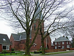
Church of St. Joseph
2010-NL-P01-Groningen-positiekaart-gemnamen.jpg
Red pog.svg
Zandberg
Netherlands location map.svg
Red pog.svg
Zandberg
Coordinates: 52°55′09″N7°01′33″E / 52.91917°N 7.02583°E / 52.91917; 7.02583 Coordinates: 52°55′09″N7°01′33″E / 52.91917°N 7.02583°E / 52.91917; 7.02583
Country Netherlands
Province(s) Groningen
Drenthe
Municipalities Westerwolde
Borger-Odoorn
Area
[1]
  Total0.90 km2 (0.35 sq mi)
Elevation
[2]
10 m (30 ft)
Population
 (2021) [1]
  Total55
  Density61/km2 (160/sq mi)
Time zone UTC+1 (CET)
  Summer (DST) UTC+2 (CEST)
Postal code
9564 [1]
Dialing code 0599

Zandberg is a village in the north of the Netherlands, partly located in the Groningen municipality of Westerwolde and partly in the Drenthe municipality of Borger-Odoorn. The village was created in the early nineteenth century as a settlement in the peat colonies. The first residents came from the neighboring part of Germany. Zandberg is therefore one of the Catholic enclaves in the Northern Netherlands.

Zandberg owes its name to the sand head, also known as the Schaapsberg, in the green grounds along the stream that was called upstream from Zandberg Valtherdiep and downstream Mussel-Aa. This hill was used to feed sheep and there were possibly huts for the herdsmen of cattle. It was on the border between the Marks Onstwedde and Valthe and was disputed by both. The Semslinie decided this dispute in favor of Valthe.

The village gained some fame in 2002 when the Giro d'Italia passed through the village, where an intermediate sprint was held. In 2004 the bond with Italy was strengthened once again when pastor Jaring de Wolff dedicated a memorial mass to Italian cyclist Marco Pantani who died in that year. Officially, the cyclists did not drive through the town of Zandberg in 2002, but through the Zandberg street, located in Ter Apelkanaal, the village next door. A mistake was made at the time and, the name Ter Apelkanaal was replaced by Zandberg during the Giro.

Zandberg had a stopping point between 1924 and 1935 that lay on the Stadskanaal to Ter Apel railway line. The track has since been demolished, but the station remains intact.

According to information from the municipality of Borger-Odoorn, the province of Zandberg in Drenthe counted 52 inhabitants on 1 January 2007 (24 men and 28 women). No precise details are available for the Groningen part.

Related Research Articles

<span class="mw-page-title-main">Drenthe</span> Province of the Netherlands

Drenthe is a province of the Netherlands located in the northeastern part of the country. It is bordered by Overijssel to the south, Friesland to the west, Groningen to the north, and the German state of Lower Saxony to the east. As of November 2019, Drenthe had a population of 493,449 and a total area of 2,680 km2 (1,030 sq mi).

<span class="mw-page-title-main">Vlagtwedde</span> Village in Groningen, Netherlands

Vlagtwedde is a village in the very southeast of Groningen province in the northeastern Netherlands. It lies on the Dutch border with the German state of Lower Saxony to the east.

<span class="mw-page-title-main">Borger-Odoorn</span> Municipality in Drenthe, Netherlands

Borger-Odoorn is a municipality in the northeastern Netherlands in the province of Drenthe.

<span class="mw-page-title-main">Borger, Netherlands</span> Village in Drenthe, Netherlands

Borger is a village in the Dutch province of Drenthe. It is a part of the municipality of Borger-Odoorn, and lies about 18 km east of Assen.

<span class="mw-page-title-main">Westdorp</span> Place in Drenthe, Netherlands

Westdorp is a village in the Dutch province of Drenthe. It is a part of the municipality of Borger-Odoorn, and lies about 17 km northwest of Emmen.

<span class="mw-page-title-main">Drouwenermond</span> Place in Drenthe, Netherlands

Drouwenermond is a village in the Dutch province of Drenthe. It is a part of the municipality of Borger-Odoorn, and lies about 23 km north of Emmen.

<span class="mw-page-title-main">Nieuw-Buinen</span> Village in Drenthe, Netherlands

Nieuw-Buinen is a village in the Dutch province of Drenthe. It is a part of the municipality of Borger-Odoorn, and lies about 21 kilometres (13 mi) north of Emmen.

<span class="mw-page-title-main">Eeserveen</span> Village in Drenthe, Netherlands

Eeserveen is a village in the Dutch province of Drenthe. It is a part of the municipality of Borger-Odoorn, and lies about 14 km northwest of Emmen.

<span class="mw-page-title-main">Odoorn</span> Village in Drenthe, Netherlands

Odoorn is a village in the Dutch province of Drenthe. It is a part of the municipality of Borger-Odoorn, and lies about nine km north of Emmen.

<span class="mw-page-title-main">Exloo</span> Village in Drenthe, Netherlands

Exloo is a village in the province of Drenthe, Netherlands, part of the municipality of Borger-Odoorn. It lies about 12 km north of Emmen.

<span class="mw-page-title-main">Valthe</span> Village in Drenthe, Netherlands

Valthe is a village in the Dutch province of Drenthe. It is a part of the municipality of Borger-Odoorn, and lies about 8 km north of Emmen.

<span class="mw-page-title-main">Klijndijk</span> Village in Drenthe, Netherlands

Klijndijk is a village in the Dutch province of Drenthe. It is a part of the municipality of Borger-Odoorn, and lies about 7 km north of Emmen.

<span class="mw-page-title-main">Odoornerveen</span> Village in Drenthe, Netherlands

Odoornerveen is a village in the Dutch province of Drenthe. It is a part of the municipality of Borger-Odoorn, and lies about 12 km northwest of Emmen.

<span class="mw-page-title-main">1e Exloërmond</span> Village in Drenthe, Netherlands

1e Exloërmond is a village in the Dutch province of Drenthe. It is a part of the municipality of Borger-Odoorn, and lies about 18 km north of Emmen.

<span class="mw-page-title-main">Valthermond</span> Village in Drenthe, Netherlands

Valthermond is a village in the Dutch province of Drenthe. It is a part of the municipality of Borger-Odoorn, and lies about 18 km north of Emmen.

<span class="mw-page-title-main">Ter Apelkanaal</span> Village in Groningen, Netherlands

Ter Apelkanaal is a town in the Dutch province of Groningen. It is a part of the municipality of Westerwolde, and lies about 17 km (11 mi) northeast of Emmen.

<span class="mw-page-title-main">Semslinie</span>

The Semslinie is a part of the border between the Dutch provinces of Groningen and Drenthe that runs right through the former Bourtanger Moor. The almost straight line runs from Wolfsbarge to the Huis ter Haar at Musselkanaal. The border is slightly bent at Stadskanaal. The slightly bent line between Musselkanaal and Stadskanaal is sometimes called Koningsraai. The Semslinie is named after Johan Sems.

<span class="mw-page-title-main">Westerwolde (municipality)</span> Municipality in Groningen, Netherlands

Westerwolde is a municipality in the province of Groningen in the northeast of the Netherlands.

<span class="mw-page-title-main">Musselkanaal</span> Town in Groningen, Netherlands

Musselkanaal is a town in the Dutch province of Groningen. It is located in the municipality of Stadskanaal. It was established by the city of Groningen in the 1840s to exploit the peat. It used to be part of the municipality of Onstwedde, but was merged into Stadskanaal in 1968.

References

  1. 1 2 3 "Kerncijfers wijken en buurten 2021". Central Bureau of Statistics. Retrieved 11 April 2022. Drenthe only. 360 people live both in Jipsingboermussel and Zandberg, Groningen
  2. "Postcodetool for 9564PA". Actueel Hoogtebestand Nederland (in Dutch). Het Waterschapshuis. Retrieved 11 April 2022.