Vlagtwedde

Last updated • 1 min readFrom Wikipedia, The Free Encyclopedia
Vlagtwedde
Vlagtwedde 01.JPG
Protestant Church in Vlagtwedde in 2007
Map - NL - Municipality code 0048 (2009).svg
Location in Groningen
2010-NL-P01-Groningen-positiekaart-gemnamen.jpg
Red pog.svg
Vlagtwedde
Location in the province of Groningen in the Netherlands
Netherlands location map.svg
Red pog.svg
Vlagtwedde
Vlagtwedde (Netherlands)
Coordinates: 52°57′N7°9′E / 52.950°N 7.150°E / 52.950; 7.150
Country Netherlands
Province Groningen
Municipality Westerwolde
EstablishedDecember 1811;212 years ago (1811-12)
Disestablished1 January 2018;6 years ago (2018-01-01)
Area
[1]
  Total170.55 km2 (65.85 sq mi)
  Land167.62 km2 (64.72 sq mi)
  Water2.93 km2 (1.13 sq mi)
Elevation
[2]
8 m (26 ft)
Population
 (January 2021) [3]
  Totaldata missing
Demonym Vlagtwedder
Time zone UTC+1 (CET)
  Summer (DST) UTC+2 (CEST)
Postcode
9540–9564
Area code 0599
Website www.vlagtwedde.nl
Map of Vlagtwedde, June 2015 Gem-Vlagtwedde-OpenTopo.jpg
Map of Vlagtwedde, June 2015

Vlagtwedde (Dutch pronunciation: [ˈvlɑxˌtʋɛdə] ) is a village in the very southeast of Groningen province in the northeastern Netherlands. It lies on the Dutch border with the German state of Lower Saxony to the east.

Contents

History

The municipality of Vlagtwedde was created in December 1811. [4]

On 1 January 2018, the municipality of Vlagtwedde was merged with Bellingwedde to form the new municipality of Westerwolde. [5]

Geography

The population centres in the municipality of Vlagtwedde were:

Abeltjeshuis, Bakovensmee, Barnflair, Borgertange, Borgerveld, Bourtange, Burgemeester Beinsdorp, De Bruil, Ellersinghuizen, Hanetange, Harpel, Hasseberg, Hebrecht, 't Heem, Jipsingboermussel, Jipsingboertange, Jipsinghuizen, Lammerweg, Laude, Lauderbeetse, Laudermarke, Lauderzwarteveen, Leemdobben, Maten, Munnekemoer, Over de Dijk, Overdiep, Pallert, Plaggenborg, Poldert, Renneborg, Rhederveld, Rijsdam, Roelage, 't Schot, Sellingen, Sellingerbeetse, Sellingerzwarteveen, Slegge, Stakenborg, Stobben, Ter Apel, Ter Apelkanaal, Ter Borg, Ter Haar, Ter Walslage, Ter Wisch, Veele, Veerste Veldhuis, Vlagtwedde, Vlagtwedder-Barlage, Vlagtwedder-Veldhuis, Weende, Weenderveld, Weite, Wessingtange, Wollingboermarke, Wollinghuizen, Zandberg and Zuidveld.

Because of the large number of official centres, the municipality had five postal codes:

All 60 villages and hamlets in the municipality received their own town sign in 2008.

Politics

The municipal council of Vlagtwedde had 17 seats. The table below gives results since 2002. [6]

Council seats
Party2002200620102014
Local municipal interests3455
CDA 5334
PvdA 4643
VVD 3221
GreenLeft 1121
ChristianUnion 1111
Party for the Animals 0001
D66 0001
Total17171717

There was an election in November 2017 for the council of the new merged Westerwolde municipality that commenced work on 1 January 2018, replacing Vlagtwedde council. [7]

Public transport

Vlagtwedde is served by several bus lines:

International relations

Vlagtwedde is twinned with:

Related Research Articles

<span class="mw-page-title-main">Groningen (province)</span> Northeasternmost province of the Netherlands

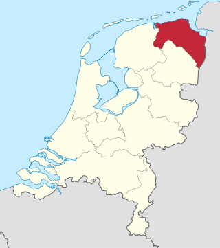
Groningen is the northeasternmost province of the Netherlands. It borders on Friesland to the west, Drenthe to the south, the German state of Lower Saxony to the east, and the Wadden Sea to the north. As of January 2023, Groningen had a population of about 596,000, and a total area of 2,955 km2 (1,141 sq mi).

<span class="mw-page-title-main">Bellingwedde</span> Municipality in Groningen, Netherlands

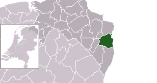
Bellingwedde was a municipality in the province Groningen in the northeast of the Netherlands. Bellingwedde was established in 1968, when the municipalities of Bellingwolde and Wedde merged. After almost 50 years, Bellingwedde was disestablished in 2018, when the municipalities of Bellingwedde and Vlagtwedde merged into Westerwolde.

<span class="mw-page-title-main">Haren, Groningen</span> Place in Groningen, Netherlands

Haren is a town and a former municipality in the northeastern Netherlands. It is located in the direct urban area of the City of Groningen and, in January 2019, was merged into municipality of Groningen.

<span class="mw-page-title-main">Pekela</span> Municipality in Groningen, Netherlands

Pekela is a municipality in the province of Groningen in the Netherlands. It was created in 1990 when Oude Pekela and Nieuwe Pekela were merged.

<span class="mw-page-title-main">Bourtange</span> Village in Groningen, Netherlands

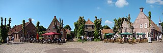
Bourtange is a village with a population of 430 in the municipality of Westerwolde in the Netherlands. It is situated in the region Westerwolde in the east of the province of Groningen near the German border. Fort Bourtange was built in 1593 during the Dutch Revolt and was used until 1851. Between 1967 and 1992 the star fort was gradually restored to its mid-18th-century state and it is currently an open-air museum.

<span class="mw-page-title-main">Ter Apel</span> Village in Groningen, Netherlands

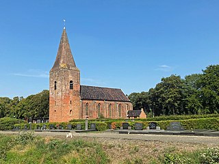
Ter Apel is a village with a population of 9,914 residents in the municipality Westerwolde in the northern Netherlands, in the province Groningen in the region Westerwolde. The town lies on the stream Ruiten Aa, which has the valley that together with the Ter Apeler forest belongs to the national network of nature reserves, the Ecologische Hoofdstructuur. An accommodation centre for refugees is located at Ter Apel, functioning as a "departure centre" for rejected refugees and a registration point, operated by the Centraal Orgaan opvang Asielzoekers. Ter Apel lies on the roads N366, N976 and N391. It forms the southern point of the border between Groningen and Drenthe, the Semslinie.

<span class="mw-page-title-main">Sellingen</span> Village in Groningen, Netherlands

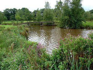
Sellingen is a village in the Dutch province of Groningen. It is a part of the municipality of Westerwolde, and lies about 25 kilometres (16 mi) northeast of Emmen. In 2021, statistical area "Sellingen", which also includes the surrounding countryside, had a population of 1,880, and the village of Sellingen had 1,045.

Vlagtwedder-Veldhuis is a hamlet in the Dutch province of Groningen. It is a part of the municipality of Westerwolde, and lies about 30 km north of Emmen.

<span class="mw-page-title-main">Veele</span> Hamlet in Groningen, Netherlands

Veele is a hamlet in the Dutch province of Groningen. It is a part of the municipality of Westerwolde, and lies about 32 km north of Emmen.

<span class="mw-page-title-main">Ter Apelkanaal</span> Village in Groningen, Netherlands

Ter Apelkanaal is a town in the Dutch province of Groningen. It is a part of the municipality of Westerwolde, and lies about 17 km (11 mi) northeast of Emmen.

<span class="mw-page-title-main">Munnekemoer</span> Hamlet in Groningen, Netherlands

Munnekemoer is a hamlet in the Dutch province of Groningen. It is a part of the municipality of Westerwolde, and lies about 14 km northeast of Emmen.

Burgemeester Beinsdorp is a hamlet in the Dutch province of Groningen. It is a part of the municipality of Westerwolde, and lies about 15 km northeast of Emmen.

<span class="mw-page-title-main">De Maten</span> Hamlet in Groningen, Netherlands

De Maten is a hamlet in the Dutch province of Groningen. It is a part of the municipality of Westerwolde, and lies about 14 km northeast of Emmen.

<span class="mw-page-title-main">Bellingwolde</span> Village in Groningen, Netherlands

Bellingwolde is a village with a population of 2,655 people in the municipality Westerwolde in the Netherlands. It is situated in the southeast of the region Oldambt, in the north of the region Westerwolde, and in the east of the province Groningen, at the border with Germany.

<span class="mw-page-title-main">Onstwedde</span> Village in Groningen, Netherlands

Onstwedde is a village in the region of Westerwolde and part of Groningen in the Netherlands. It is located in the municipality of Stadskanaal.

<span class="mw-page-title-main">Westerwolde (region)</span> Region in Groningen, Netherlands

Westerwolde is a region in the province Groningen in the north of the Netherlands. The region is located in the most eastern part of the Netherlands, alongside the German border. It is situated around the rivers Mussel Aa, Ruiten Aa, and Westerwoldse Aa, and it contains the villages Bellingwolde, Blijham, Onstwedde, Sellingen, Ter Apel, Vlagtwedde, Vriescheloo, and Wedde. The people in Westerwolde speak Dutch and the West Low German dialect Westerwolds.

<span class="mw-page-title-main">Veelerveen</span> Village in Groningen, Netherlands

Veelerveen is a linear village with a population of around 720 in the municipality of Westerwolde in the Netherlands.

<span class="mw-page-title-main">Westerwolde (municipality)</span> Municipality in Groningen, Netherlands

Westerwolde is a municipality in the province of Groningen in the northeast of the Netherlands.

<span class="mw-page-title-main">Zandberg, Groningen-Drenthe</span> Village in Netherlands

Zandberg is a village in the north of the Netherlands, partly located in the Groningen municipality of Westerwolde and partly in the Drenthe municipality of Borger-Odoorn. The village was created in the early nineteenth century as a settlement in the peat colonies. The first residents came from the neighboring part of Germany. Zandberg is therefore one of the Catholic enclaves in the Northern Netherlands.

<span class="mw-page-title-main">Musselkanaal</span> Town in Groningen, Netherlands

Musselkanaal is a town in the Dutch province of Groningen. It is located in the municipality of Stadskanaal. It was established by the city of Groningen in the 1840s to exploit the peat. It used to be part of the municipality of Onstwedde, but was merged into Stadskanaal in 1968.

References

  1. "Kerncijfers wijken en buurten 2020" [Key figures for neighbourhoods 2020]. StatLine (in Dutch). CBS. 24 July 2020. Retrieved 19 September 2020.
  2. "Postcodetool for 9551AB". Actueel Hoogtebestand Nederland (in Dutch). Het Waterschapshuis. Retrieved 5 February 2014.
  3. "Bevolkingsontwikkeling; regio per maand" [Population growth; regions per month]. CBS Statline (in Dutch). CBS. 1 January 2021. Retrieved 2 January 2022.
  4. "Geschiedenis" (in Dutch), Municipality of Vlagwedde. Retrieved 28 December 2017.
  5. Marcel Looden, "Westerwolde: 40 mensen tekort" (in Dutch), Dagblad van het Noorden , 2017. Retrieved 28 December 2017.
  6. "Vlagtwedde municipal election 2014". verkiezingsuitslagen.nl (in Dutch). 19 March 2014. Retrieved 30 June 2024.
  7. "Westerwolde municipal election 2017". verkiezingsuitslagen.nl (in Dutch). 22 November 2017. Retrieved 30 June 2024.