Gmina Sobienie-Jeziory is a rural gmina in Otwock County, Masovian Voivodeship, in east-central Poland. Its seat is the village of Sobienie-Jeziory, which lies approximately 19 kilometres south of Otwock and 39 km south-east of Warsaw.
Okopy-Kolonia is a village in the administrative district of Gmina Dorohusk, within Chełm County, Lublin Voivodeship, in eastern Poland, close to the border with Ukraine.
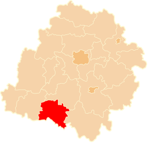
Walentynów is a village in the administrative district of Gmina Krzczonów, within Lublin County, Lublin Voivodeship, in eastern Poland.

Wały A is a village in the administrative district of Gmina Krzyżanów, within Kutno County, Łódź Voivodeship, in central Poland. It lies approximately 7 kilometres (4 mi) south of Kutno and 44 km (27 mi) north of the regional capital Łódź.
Justynów is a village in the administrative district of Gmina Aleksandrów, within Piotrków County, Łódź Voivodeship, in central Poland. It lies approximately 4 kilometres (2 mi) south-east of Aleksandrów, 29 km (18 mi) south-east of Piotrków Trybunalski, and 71 km (44 mi) south-east of the regional capital Łódź.
Sierakowice Lewe is a village in the administrative district of Gmina Skierniewice, within Skierniewice County, Łódź Voivodeship, in central Poland. It lies approximately 8 kilometres (5 mi) north-west of Skierniewice and 49 km (30 mi) north-east of the regional capital Łódź.

Goszyce is a village in the administrative district of Gmina Kocmyrzów-Luborzyca, within Kraków County, Lesser Poland Voivodeship, in southern Poland. It lies approximately 19 km (12 mi) north-east of the regional capital Kraków.
Wierzchowiska Drugie is a village in the administrative district of Gmina Piaski, within Świdnik County, Lublin Voivodeship, in eastern Poland.
Zapole is a village in the administrative district of Gmina Niwiska, within Kolbuszowa County, Subcarpathian Voivodeship, in south-eastern Poland. It lies approximately 6 kilometres (4 mi) south-east of Niwiska, 9 km (6 mi) south-west of Kolbuszowa, and 30 km (19 mi) north-west of the regional capital Rzeszów.
Kolonia Dąbrówka is a village in the administrative district of Gmina Tarłów, within Opatów County, Świętokrzyskie Voivodeship, in south-central Poland. It lies approximately 3 kilometres (2 mi) east of Tarłów, 33 km (21 mi) north-east of Opatów, and 81 km (50 mi) east of the regional capital Kielce.

Michniówpronounced [ˈmixɲuf] is a village in the administrative district of Gmina Suchedniów, within Skarżysko County, Świętokrzyskie Voivodeship, in south-central Poland. It lies approximately 5 kilometres (3 mi) south of Suchedniów, 14 km (9 mi) south-west of Skarżysko-Kamienna, and 22 km (14 mi) north-east of the regional capital Kielce.
Górki is a village in the administrative district of Gmina Dębe Wielkie, within Mińsk County, Masovian Voivodeship, in east-central Poland.
Stara Ciświca is a village in the administrative district of Gmina Grodziec, within Konin County, Greater Poland Voivodeship, in west-central Poland. It lies approximately 30 kilometres (19 mi) south-west of Konin and 86 km (53 mi) south-east of the regional capital Poznań.
Międzylesie is a village in the administrative district of Gmina Rogoźno, within Oborniki County, Greater Poland Voivodeship, in west-central Poland. It lies approximately 3 kilometres (2 mi) south of Rogoźno, 16 km (10 mi) north-east of Oborniki, and 37 km (23 mi) north of the regional capital Poznań.
Bartodzieje is a village in the administrative district of Gmina Wągrowiec, within Wągrowiec County, Greater Poland Voivodeship, in west-central Poland. It lies approximately 6 kilometres (4 mi) north of Wągrowiec and 53 km (33 mi) north of the regional capital Poznań.
Stara Dąbrowa is a village in the administrative district of Gmina Wolsztyn, within Wolsztyn County, Greater Poland Voivodeship, in west-central Poland. It lies approximately 5 kilometres (3 mi) south-east of Wolsztyn and 61 km (38 mi) south-west of the regional capital Poznań.
Borowa is a village in the administrative district of Gmina Miedźno, within Kłobuck County, Silesian Voivodeship, in southern Poland. It lies approximately 12 kilometres (7 mi) north-east of Kłobuck and 85 km (53 mi) north of the regional capital Katowice.
Bieniów is a village in the administrative district of Gmina Żary, within Żary County, Lubusz Voivodeship, in western Poland. It lies approximately 10 kilometres (6 mi) north of Żary and 34 km (21 mi) south-west of Zielona Góra.
Szropy Niziny is a village in the administrative district of Gmina Stary Targ, within Sztum County, Pomeranian Voivodeship, in northern Poland. It lies approximately 10 kilometres (6 mi) north of Stary Targ, 13 km (8 mi) north-east of Sztum, and 53 km (33 mi) south-east of the regional capital Gdańsk.
Zapole is a village in the administrative district of Gmina Karnice, within Gryfice County, West Pomeranian Voivodeship, in north-western Poland. It lies approximately 4 kilometres (2 mi) south of Karnice, 14 km (9 mi) north-west of Gryfice, and 72 km (45 mi) north-east of the regional capital Szczecin.