Abraham Gottlob Werner was a German geologist who set out an early theory about the stratification of the Earth's crust and propounded a history of the Earth that came to be known as Neptunism. While most tenets of Neptunism were eventually set aside, Werner is remembered for his demonstration of chronological succession in rocks; for the zeal with which he infused his pupils; and for the impulse he thereby gave to the study of geology. He has been called the "father of German geology".
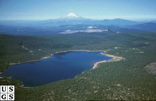
Medicine Lake Volcano is a large shield volcano in northeastern California about 30 miles (50 km) northeast of Mount Shasta. The volcano is located in a zone of east-west crustal extension east of the main axis of the Cascade Volcanic Arc and the Cascade Range. The 0.6-mile (1 km) thick shield is 22 miles (35 km) from east to west and 28 to 31 miles from north to south, and covers more than 770 square miles (2,000 km2). The underlying rock has downwarped by 0.3 miles (0.5 km) under the center of the volcano. The volcano is primarily composed of basalt and basaltic andesite lava flows, and has a 4.3-by-7.5-mile caldera at the center.

Baunach is a town in the Upper Franconian district of Bamberg and the seat of the administrative community (Verwaltungsgemeinschaft) of Baunach. Until administrative reform in 1972, Baunach belonged to the Lower Franconian district of Ebern.

Otzberg is a municipality in the district of Darmstadt-Dieburg, located in the Odenwald forest region of Germany. It was founded in 1972 by the merger of six former independent municipalities.

Moon's Hill Quarry is a 3.42 hectare geological Site of Special Scientific Interest at Stoke St Michael in Somerset, notified in 1996 and is a Geological Conservation Review site.

Volcanology of Canada includes lava flows, lava plateaus, lava domes, cinder cones, stratovolcanoes, shield volcanoes, submarine volcanoes, calderas, diatremes, and maars, along with examples of more less common volcanic forms such as tuyas and subglacial mounds. It has a very complex volcanological history spanning from the Precambrian eon at least 3.11 billion years ago when this part of the North American continent began to form.

Hogg Rock is a tuya volcano and lava dome in the Cascade Range of northern Oregon, located close to Santiam Pass. Produced by magma with an intermediate andesite composition, it has steep slopes and thick glassy margins. Hogg Rock exhibits normal magnetic polarity and is probably about 80,000 years old.

Robert Sibley Volcanic Regional Preserve is located in the Berkeley Hills of the East Bay region of the San Francisco Bay Area, California. The park is part of the East Bay Regional Parks District (EBRPD), covers 928 acres (3.76 km2), and lies partly in Alameda County and partly in Contra Costa County, east of Oakland. It can be entered from Oakland on Skyline Boulevard, or from Contra Costa County on Old Tunnel Road.

Mount Warrnambool is a single large scoria cone volcano that is 216 metres (709 ft) high. It is 16 kilometres (10 mi) southwest of Terang, Victoria, Australia. It is visible from the Princes Highway on the way to Warrnambool.
The Watchung Outliers include six areas of isolated low hills and rock outcrops of volcanic and sedimentary origin in the U.S. states of New York, New Jersey, and Pennsylvania. These geologic outliers are primarily diminutive and detached remnants of the Triassic/Jurassic age Watchung Mountain basalt flows with intervening layers of sedimentary rock. All six of the outliers are found along the western edge of the Newark Basin, occupying small synclines adjacent to the Ramapo fault system. The outliers, from north to south, are known as: Ladentown, Union Hill, New Germantown/Oldwick, Prospect Hill, Sand Brook, and Jacksonwald.

The Haßberge are a hill range, up to 512.2 m above sea level (NN), north of the River Main in Lower Franconia in the German state of Bavaria. The hills are in the county of Bamberg and divided by the Main valley from their sister hills, the Steigerwald. Both forested hill ranges fall steeply down to the Main. Between the Ebelsbach and Haßfurt the river cuts through the hills in a wide gap, creating an easy route between the Upper Main and the fertile Middle Main region.

Crater Hill is one of the volcanoes of the Auckland volcanic field. It consists of an explosion crater about 600m wide, partly filled with water.
The Franconian Keuper-Lias Plains or Franconian Keuper-Lias Lands are a major natural region in the South German Scarplands in Upper Franconia and to a lesser extent in the north, in the Thuringian district of Hildburghausen. As the name betrays, the term embraces both the Keuper landscapes and lias landscapes in Franconia. In addition, the foreland of the Franconian Jura, in which part of the Brown Jurassic occurs, as well as parts of the former volcanic region of Heldburger Gangschar belong to this region.

The Volcano Park in Mayen-Koblenz is a geopark in the rural district of Mayen-Koblenz in the eastern Vulkan Eifel, Germany. It was founded in 1996 and wraps around the Laacher See. Together with the Volcano Park, Brohltal/Laacher See and the Vulkan Eifel Nature and Geo-Park, it forms part of the national Eifel Volcano Land Geo-Park. The three parks are connected by the 280-kilometre-long German Volcano Route.
The Heldburger Gangschar is a Cenozoic volcanic system in the Franconian parts of southern Thuringia and northern Bavaria. The term Gangschar refers to the fact that few of the volcanoes have retained their characteristic topographical shape, rather their former activity can be detected by filled fissures known as Gänge. These veins are mostly oriented in south-southwest direction, their cross-section is often less than one metre wide. The Heldburger Gangschar' is named after the small settlement of Heldburg, part of the borough of Bad Colberg-Heldburg. The surrounding area, the Heldburger Land, belongs entirely to the northern part of the volcanic zone. The most impressive of the surviving volcanic cones by far are the twin peaks of the Gleichberge, 641 metres and 679 metres high, in nearby Heldburger Land.

Rauheneck Castle is a ruined administrative castle of the Bishopric of Würzburg in the Haßberge in the county of Haßberge, Lower Franconia, Bavaria (Germany). The site, which was badly in need of repair, was closed until 2006 due to the danger of collapse but has been accessible again since the start of, as yet unfinished, emergency repair work.

A conical hill is a landform with a distinctly conical shape. It is usually isolated or rises above other surrounding foothills, and is often, but not always, of volcanic origin.
The Keuper Uplands are part of the South German Scarplands and cover an area of about 3,200 square kilometres.
The Kranstein is a rock formation which is designated as a natural monument in the German mountain range of Westerwald. It is situated by the district road, Kreisstraße 95, between Willmenrod and Weltersburg. It is registered as number "ND-7143-507" in the list of natural monuments of the state of Rhineland-Palatinate and is a geotope in the Westerwald-Lahn-Taunus Geopark.
The geology of Mauritius and Rodrigues is comparatively recent. The oldest rocks on Mauritius are only 10 million years old and 1.54 million years old on Rodrigues Island. The mafic basalts of the two islands formed in relation to the hotspot that generated the Deccan Traps and coral reefs built on the volcanoes forming non-volcanic sediments.