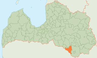
Viesīte is a town in the western part of Jēkabpils Municipality in the Selonia region of Latvia. The population in 2020 was 1,500.

Olaine is a city in Olaine Municipality in the Vidzeme region of Latvia. Olaine gained town rights in 1967. The population in 2020 was 10,668.

Dobele is a town in the cultural region Zemgale in Latvia, and is located near the center of Latvia on the banks of the river Bērze. It received town rights in 1917 whilst being a part of the German occupied Courland Governorate during the First World War. As of 2020, the population was 8,856.

Piltene is a town in northwestern Latvia. The population in 2020 was 909.

Salaspils Municipality is a municipality in Vidzeme, Latvia. The municipality was formed in 2004 by reorganization of Salaspils town and its rural territory, the administrative centre being Salaspils. In 2010 the rural territory was renamed Salaspils parish. The population in 2020 was 22,758.

Sigulda Municipality is a municipality in Vidzeme, Latvia. The municipality was formed in 2003 by merging Sigulda town, Sigulda Parish and More Parish. In 2009 it absorbed Allaži parish, too; the administrative centre being Sigulda. The population in 2020 was 17,992.
Ilūkste Municipality was a municipality in Selonia, Latvia. The municipality was formed in 2003 by merging Pilskalne Parish, Šēdere Parish, Bebrene Parish and Ilūkste town. In 2009 it absorbed Dviete parish, Eglaine parish and Subate town with its rural area the administrative centre being Ilūkste. In 2010 the rural area of Subate was reorganised as a separate territorial entity, Prode Parish. The population in 2020 was 6,412.

Preiļi Municipality is a municipality in Latgale, Latvia. The municipality was formed in 2000 by merging Aizkalne Parish, Preiļi Parish and Preiļi town. In 2009 it absorbed Pelēči Parish and Sauna Parish, too the administrative centre being Preiļi. The population in 2020 was 9,054.

Zilupe Municipality is a former municipality in the historical region of Latgale, and the Latgale Planning Region in Latvia. The municipality was formed in 2002 by merging Zaļesje Parish and Zilupe. In 2009 it absorbed Lauderi Parish and Pasiene Parish, the administrative centre being Zilupe. Zilupe, Lauderi, Zaļesje and Pasiene are among the towns and villages located in the municipality. The population as of 2020 was 2,575.

Dobele Municipality is a municipality in the historical region of Zemgale, and the Zemgale Planning Region in Latvia. The municipality was formed in 2009 by merging Dobele town and the Annenieki, Auri, Bērze, Biksti, Dobele, Jaunbērze, Krimūna, Naudīte, Penkule and Zebrene parishes, the administrative centre being Dobele. As of 2020, the population was 19,286.

Jēkabpils Municipality is a municipality in Latvia. The municipality was formed in 2009 by merging Ābeļi Parish, Dignāja Parish, Dunava Parish, Kalna Parish, Leimaņi Parish, Rubene Parish and Zasa Parish. During the 2021 Latvian administrative reform, the previous Jēkabpils Municipality was merged with Aknīste Municipality, Krustpils Municipality, Sala Municipality and Viesīte Municipality. The new municipality now fully corresponds with the area of the pre-2009 Jēkabpils District.

Jelgava Municipality is a municipality in Zemgale, Latvia. Its administrative center is Jelgava, although it is extraterritorial as the city is a separate municipality of its own.

Olaine Municipality is a municipality in Latvia. The municipality was formed in 2009 by merging Olaine parish and Olaine town the administrative centre being Olaine. The population in 2020 was 119,667.
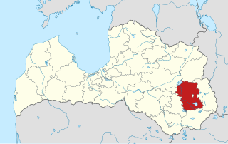
Rēzekne Municipality is a municipality in Latgale, Latvia. The municipality was formed in 2009 by merging Audriņi parish, Bērzgale parish, Čornaja parish, Dricāni parish, Feimaņi parish, Gaigalava parish, Griškāni parish, Ilzeskalns parish, Kantinieki parish, Kaunata parish, Lendži parish, Lūznava parish, Mākoņkalns parish, Malta parish, Nagļi parish, Nautrēni parish, Ozolaine parish, Ozolmuiža parish, Puša parish, Rikava parish, Sakstagals parish, Silmala parish, Stoļerova parish, Strūžāni parish and Vērēmi parish, town Viļāni. The population in 2020 was 24,127.

Saulkrasti Municipality is a municipality in Vidzeme, Latvia. The municipality was formed in 2009 by reorganization of Saulkrasti town with its countryside territory, with the administrative centre being Saulkrasti. In 2010 Saulkrasti parish was created from the countryside territory of Saulkrasti town. The population in 2020 was 6,735.
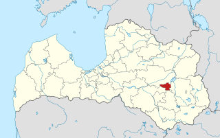
Varakļāni Municipality is a municipality in Latgale, Latvia. The municipality was formed in 2009 by merging Varakļāni town, Murmastiene Parish and Varakļāni Parish of the former Madona District. The administrative centre is Varakļāni.

Riga Region, officially Riga Planning Region and shortened as RPR is one of five planning regions of Latvia, situated in the central part of Latvia, in and around the metropolis of Riga and along the shores of the Gulf of Riga. The state institution was founded on 12 October 2006, based on the creation of the region territory as prescribed by Regulations No. 133 of the Cabinet of Ministers as of 25 March 2003, the "Regulations on Territories of Planning Regions". After the 2021 reform some Riga Region's lands were incorporated into Kurzeme and Vidzeme.

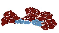
Kurzeme Region, officially Kurzeme Planning Region, is one of the five planning regions of Latvia, it is situated in the western part of Latvia, at the shores of the Baltic Sea and Gulf of Riga. The state institution was founded on 2 October 2006, based on the creation of the region territory as prescribed by Regulations No. 133 of the Cabinet of Ministers as of 25 March 2003, the "Regulations on Territories of Planning Regions". As of 2020, the region's population was 237,407.
Latgale Planning Region also known as Latgale Region, is one of the five planning regions of Latvia, it is situated in the eastern part of Latvia. The state institution was founded on 2 October 2006, based on the creation of the region territory as prescribed by Regulations No. 133 of the Cabinet of Ministers as of 25 March 2003, the "Regulations on Territories of Planning Regions". As of 2020, the region's population was 281,116.

Vidzeme Region, officially Vidzeme Planning Region is one of the five planning regions of Latvia, it is situated in the northern part of Latvia. The state institution was founded on 2 October 2006, based on the creation of the region territory as prescribed by Regulations No. 133 of the Cabinet of Ministers as of 25 March 2003, the "Regulations on Territories of Planning Regions". As of 2020, the region's population was 211,309.