
A municipality is usually a single administrative division having corporate status and powers of self-government or jurisdiction as granted by national and regional laws to which it is subordinate.

Belgium is a federal state comprising three communities and three regions that are based on four language areas. For each of these subdivision types, the subdivisions together make up the entire country; in other words, the types overlap.
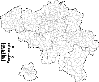
Belgium comprises 581 municipalities, 300 of them grouped into five provinces in Flanders and 262 others in five provinces in Wallonia, while the remaining 19 are in the Brussels Capital Region, which is not divided in provinces. In most cases, the municipalities are the smallest administrative subdivisions of Belgium, but in municipalities with more than 100,000 inhabitants, on the initiative of the local council, sub-municipal administrative entities with elected councils may be created. As such, only Antwerp, having over 500,000 inhabitants, became subdivided into nine districts. The Belgian arrondissements, an administrative level between province and municipality, or the lowest judicial level, are in English sometimes called districts as well.
The Federal Republic of Germany, as a federal state, consists of sixteen partly sovereign federated states. Since the German nation state was formed from an earlier collection of several states, it has a federal constitution, and the constituent states retain a measure of sovereignty.

An unincorporated area is a region that is not governed by a local municipal corporation. Widespread unincorporated communities and areas are a distinguishing feature of the United States and Canada. Most other countries of the world have either no unincorporated areas at all or these are very rare; typically remote, outlying, sparsely populated or uninhabited areas.
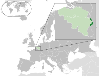
The German-speaking Community, branded since 2017 as East Belgium, is one of the three federal communities of Belgium. Covering an area of 854 km2 (330 sq mi) within the Liège Province in Wallonia, it includes nine of the eleven municipalities of Eupen-Malmedy. Traditionally speakers of Low Dietsch, Ripuarian, and Moselle Franconian varieties, the local population numbers 77,949 – about 7.0% of Liège Province and about 0.7% of the national total.

Municipalities are the lowest level of administrative division in Switzerland. Each municipality is part of one of the Swiss cantons, which form the Swiss Confederation. In most cantons municipalities are also part of districts or other sub-cantonal administrative divisions.
The Official Municipality Key, formerly also known as the Official Municipality Characteristic Number or Municipality Code Number, is a number sequence for the identification of politically independent municipalities or unincorporated areas. Other classifications for the identification of areas include postal codes, NUTS codes or FIPS codes.

The pottery town of Waldenburg lies in the valley of the Zwickauer Mulde. The environment is characterized by forest areas, river meadows and the hilly landscape of the Erzgebirge foothills.

The Region of Southern Denmark is an administrative region of Denmark established on Monday 1 January 2007 as part of the 2007 Danish Municipal Reform, which abolished the traditional counties ("amter") and set up five larger regions. At the same time, smaller municipalities were merged into larger units, cutting the number of municipalities from 271 before 1 January 2007 to 98. The reform diminished the power of the regional level dramatically in favor of the local level and the central government in Copenhagen. The Region of Southern Denmark has 22 municipalities. The reform was implemented in Denmark on 1 January 2007, although the merger of the Funish municipalities of Ærøskøbing and Marstal, being a part of the reform, was given the go-ahead to be implemented on Sunday 1 January 2006, one year before the main reform. It borders Schleswig-Holstein (Germany) to the south and Central Denmark Region to the north and is connected to Region Zealand via the Great Belt Fixed Link.

Opovo is a town and municipality located in the South Banat District of the autonomous province of Vojvodina, Serbia. The town has a population of 4,546, while Opovo municipality has 10,475 inhabitants.
Horizontina is a municipality and a city in Rio Grande do Sul, in southern Brazil, with 19,389 inhabitants in 2020. It is located 496 km north of the state capital. The first settlers were German, Italian and Polish immigrants who arrived in the region in 1927, though the city was created only in 1955. Nowadays, most of the inhabitants are of German-Brazilian descent.

Stara Pazova is a town and municipality located in the Srem District of the autonomous province of Vojvodina, Serbia. The town has a population of 64792, while Stara Pazova municipality has 65,792 inhabitants. The entrance into town from Inđija lies on 45th parallel north, it is half-way between the North pole and the equator.

Municipalities are the lowest level of official territorial division in Germany. This can be the second, third, fourth or fifth level of territorial division, depending on the status of the municipality and the Land it is part of. The city-states Berlin and Hamburg are second-level divisions. A Gemeinde is one level lower in those states which also include Regierungsbezirke as an intermediate territorial division. The Gemeinde is one level higher if it is not part of a Gemeindeverband.
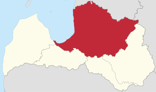
Vidzeme is one of the Historical Latvian Lands. The capital of Latvia, Riga, is situated in the southwestern part of the region. Population: around 1.3 million (year?). Literally meaning "the Middle Land", it is situated in north-central Latvia north of the Daugava River. Sometimes in German, it is also known as Livland, the German form from Latin Livonia, though it comprises only a small part of Medieval Livonia and about half of Swedish Livonia. Most of the region's inhabitants are Latvians (85%), thus Vidzeme is the most ethnically Latvian region in the country.

Euerdorf is a municipality in the district of Bad Kissingen in Bavaria in Germany.

Oberwiera is a municipality in the district of Zwickau in Saxony in Germany. Oberwiera has the following districts: Harthau, Neukirchen, Niederwiera, Oberwiera, Röhrsdorf and Wickersdorf. Around half of the population lives in the main district of Oberwiera.

Nobitz is a municipality in the district Altenburger Land, in Thuringia, Germany. The nearby Nobitz airfield was used by Ryanair for flights to and from London Stansted between 2003 and 2011.
Wieratal is a former Verwaltungsgemeinschaft in the district Altenburger Land, in Thuringia, Germany. The seat of the Verwaltungsgemeinschaft was in Langenleuba-Niederhain. It was disbanded in July 2018.


