
Clarence Island is the easternmost island in the South Shetland Islands, off the coast of Antarctica. It is claimed by Argentina as part of Argentine Antarctica, by Britain as part of the British Antarctic Territory, and by Chile as part of the Chilean Antarctic Territory. The name dates back to at least 1820 and is now established in international usage, except for Russia, where it has been known as Shishkova Island since its discovery by the First Russian Antarctic Expedition in 1821.

Tower Island is an Antarctic island 9 kilometres (5 nmi) long and 305 m (1,001 ft) high. It marks the north-east extent of Palmer Archipelago. It lies 37 kilometres (20 nmi) north-east of Trinity Island, separated by Gilbert Strait. Both islands are separated from the Davis Coast to the south by Orléans Strait, running northeast–southwest. The Pearl Rocks lie off the West Coast of Tower Island.

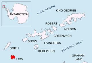
Smith Island is 20 miles (32 km) long and 5 miles wide, lying 49 miles (79 km) west of Deception Island in the South Shetland Islands of the British Antarctic Territory. It is separated from Snow Island by the 25 miles (40 km)-wide Boyd Strait, and from Low Island by the 17 miles (27 km)-wide Osmar Strait. Surface area is 148 square kilometres (57 sq mi).

Liège Island is an island, 17 kilometres (9 nmi) long and 5.6 kilometres (3 nmi) wide, lying immediately northeast of Brabant Island in the Palmer Archipelago, and separated from Hoseason Island and Christiania Islands to the northeast by Croker Passage. Its interior is occupied by Brugmann Mountains.
Trinity Island or Île de la Trinité or Isla Trinidad is an island 24 km (15 mi) long and 10 km (6 mi) wide in the northern part of the Palmer Archipelago, Antarctica. It lies 37 km (23 mi) east of Hoseason Island, 72.6 km (45 mi) south of Deception Island in the South Shetland Islands, and 10.3 km (6 mi) north-northwest of Cape Andreas on the Antarctic Peninsula. The island was named by Otto Nordenskiöld, leader of the 1901-1904 Swedish Antarctic Expedition (SAE) in commemoration of Edward Bransfield's "Trinity Land" of 1820.

Struma Glacier is a glacier in eastern Livingston Island in the South Shetland Islands, Antarctica situated south of lower Kaliakra Glacier and north of Huron Glacier. Bounded by Melnik Ridge to the north, Yankov Gap to the west and Bowles Ridge to the south, it is 4.8 km long and 1.5 km wide, and flows eastwards into Moon Bay south of Sindel Point.

The Antarctic Place-names Commission was established by the Bulgarian Antarctic Institute in 1994, and since 2001 has been a body affiliated with the Ministry of Foreign Affairs of Bulgaria.

Sewing-Machine Needles, also known as Rocas Ministro Ezcurra is a group of three prominent rock needles, the highest 45 m above water, lying close southeast of Rancho Point, Deception Island, in the South Shetland Islands. The name Sewing-Machine Rock was given by whalers for what was originally a conspicuous natural arch. Needles is now considered the more suitable descriptive term; an earthquake tremor in 1924 caused the arch to collapse. The name Rocas Ministro Ezcurra was given by Dr Douglas Mawson, leader of the Australasian Antarctic Expedition of 1912-14.

Sierra Island is a narrow island which is marked by a series of small elevations throughout its length, lying 0.5 miles (0.8 km) northwest of Dee Island and north of Greenwich Island in the South Shetland Islands, Antarctica. Surface area 14 hectares.

The Zed Islands are a small group of islands, the westernmost rising to 290 m (951 ft), lying off the northeast extremity of Livingston Island in the South Shetland Islands, Antarctica comprising four islands: Esperanto Island, Phanagoria Island, Lesidren Island and Koshava Island, and the adjacent Dlagnya and Goritsa Rocks. The group is separated from Williams Point on Varna Peninsula, Livingston Island to the south by the 1.50 km (0.93 mi) wide Iglika Passage.
The Ibar Rocks are two rocks located 0.4 kilometres (0.2 nmi) east of Bonert Rock and 1 kilometre (0.6 nmi) southeast of Canto Point, Greenwich Island, in the South Shetland Islands. The names "Islote Ibar" and "Islote Teniente Ibar" appearing on Chilean hydrographic charts in the 1950s refer to the larger and western rock. The recommended name "Ibar Rocks" includes a submerged outlier to the northeast of the larger rock. Teniente (lieutenant) Mario Ibar P. signed the official act of inauguration of the Chilean Captain Arturo Prat Base on Greenwich Island in 1947.
Express Island is a narrow and craggy island, 1.23 kilometres (0.76 mi) long, lying close offshore of northwest Greenwich Island in the South Shetland Islands, Antarctica. It is situated due north of Greaves Peak, forming most of the east side of Razlog Cove. Surface area 29 hectares.

Astor Island is an island lying between Rugged Island and Livingston Island in the South Shetland Islands, Antarctica. Surface area 12 hectares.

Gramada Glacier is a 1.6 nautical miles long glacier on Smith Island in the South Shetland Islands, Antarctica draining the southeast slopes of Imeon Range east of Riggs Peak, southeast of Madan Saddle and south of Neofit Peak. It is situated southwest of Armira Glacier and northeast of Letnitsa Glacier, and flows southeastward into Brashlyan Cove on Osmar Strait. The glacier is named after the town of Gramada in northwestern Bulgaria.

Okol Rocks is a group of rocks in the north of Aitcho Islands group on the west side of English Strait in the South Shetland Islands, Antarctica. The principal feature in the group is Lambert Island (62°22′16″S59°45′49″W).

Grigorov Glacier is a glacier 1.8 km long and 1.3 km wide on the south side of Stavertsi Ridge on Albena Peninsula, Brabant Island in the Palmer Archipelago, Antarctica. It drains the east slopes of Mount Cabeza and flows southeastwards to enter Hill Bay west of Kostur Point.

Chaos Reef is the confused area of breakers and shoal water in the north extremity of Aitcho Islands group on the west side of English Strait in the South Shetland Islands, Antarctica. The area was visited by early 19th century sealers operating from nearby Clothier Harbour.

Grace Rock is a rock in Bransfield Strait, Antarctica lying 1.72 kilometres (0.93 nmi) off the southeast coast of Nelson Island in the South Shetland Islands. It was named by the UK Antarctic Place-Names Committee in 1961 after the British sealing vessel Grace from Plymouth, which visited the South Shetland Islands in 1821–22.
Pig Rock is a rock, 65 m high, the largest of a group of rocks lying 1.9 kilometres (1 nmi) east of the east end of Nelson Island, in the South Shetland Islands. This rock, known to sealers in the area as early as 1821, was charted and named by DI personnel on the Discovery II in 1935.
Prisad Island is the rocky island off the north coast of Low Island in the South Shetland Islands extending 640 m in southwest–northeast direction and 520 m wide. It is separated from Limets Peninsula by a 60 m wide passage.

