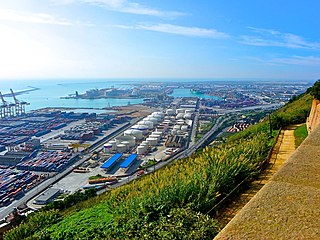
The Port of Barcelona has a 2000-year history and great contemporary commercial importance as one of Europe's ports in the Mediterranean, as well as Catalonia's largest port, tying with Tarragona. It is also Spain's third and Europe's ninth largest container port, with a trade volume of 2.57 million TEUs in 2008. The port is managed by the Port Authority of Barcelona. Its 7.86 km2 (3 sq mi) are divided into three zones: Port Vell, the commercial/industrial port, and the logistics port. The port is undergoing an enlargement that will double its size by diverting the mouth of the Llobregat River 2 km (1.2 mi) to the south and slightly pushing back the Llobregat Delta Nature Reserve.

Barcelona, Catalonia, Spain proper is divided into 10 districts. These are administrated by a councillor designated by the main city council, and each of them have some powers relating to issues such as urbanism or infrastructure in their area. The current division of the city into different districts was approved in 1984. In 2009, in Barcelona started using a new division of 73 neighbourhoods, a division that was done for a better service from the City Council.

Plaça d'Espanya or Plaza de España in Spanish, is one of Barcelona's most important squares, built on the occasion of the 1929 International Exhibition, held at the foot of Montjuïc, in the Sants-Montjuïc district.
Ildefons Cerdà is a railway station on the Llobregat–Anoia Line. It is not properly located in Plaça d'Ildefons Cerdà, but in the L'Hospitalet de Llobregat municipality, in Catalonia, Spain. The station is situated underneath Gran Via de les Corts Catalanes and was opened in 1987. It is served by Barcelona Metro line 8, Baix Llobregat Metro lines S33, S4 and S8, and commuter rail lines R5, R6, R50 and R60.
Line 10 is the name of one of the two branches of the Barcelona metro line 9, currently under construction and to be operated by TMB. Like Line 9 and Line 11, it will be an automatic train operation metro line.
Plaça d'Ildefons Cerdà is a square in Barcelona, part of La Bordeta, in the Sants-Montjuïc district, very close to the boundary of the municipality of L'Hospitalet de Llobregat. It's named after the city's renowned urban planner Ildefons Cerdà. It is essentially a large roundabout which connects different parts of the city. The new courts of Barcelona and L'Hospitalet de Llobregat, collectively known under the name Ciutat de la Justícia are located in the immediacy of this square. Recent redevelopment has changed the area's feel, as well as promotion of the different Fira de Barcelona venues, not far from the square. Decisions made by recent urbanists has been criticised as a place hostile to strollers and therefore quite different from the idea of Barcelona an urbanist like Ildefons Cerdà had. A monument to Cerdà by sculptor Antoni Riera Clavillé was inaugurated in 1959, one century after his original urban plan, but was removed shortly after General Jorge Vigón, the Francoist Minister of Public Works, dismissed it publicly. There is no name plate in the square, which makes it theoretically a nameless space.

La Sagrera is a neighborhood of Barcelona.
La Bordeta is a neighborhood in the Sants-Montjuïc district of Barcelona, Catalonia (Spain). It is located between Sants and l'Hospitalet de Llobregat. The neighborhood was in the bottom of the former municipality of Sants.
Hostafrancs is a neighbourhood in the Sants-Montjuïc district of Barcelona, Catalonia, Spain.
La Marina del Prat Vermell is a neighborhood in the Sants-Montjuïc district of Barcelona, Catalonia (Spain). The name comes from fields that occupied this area of low part of la Marina de Sants. This is a new neighborhood that is developing between the other sector of la Marina de Sants, la Marina de Port, and the industrial area of Zona Franca.
La Marina de Port is a neighborhood in the Sants-Montjuïc district of Barcelona, Catalonia (Spain), and is one of the two parts of la Marina de Sants. It lies between the districts of la Bordeta, la Marina del Prat Vermell.

El Poble-sec is a neighborhood in the Sants-Montjuïc district of Barcelona, Catalonia (Spain). The neighborhood is located between Montjuïc mountain and the Avinguda del Paral·lel.
Zona Franca is a logistics and industrial area located in the Sants-Montjuïc district of Barcelona, Catalonia (Spain). It is near the C-31 road and la Marina de Sants (Barcelona), el Prat de Llobregat and l'Hospitalet de Llobregat. It is situated in a very strategic position between Barcelona Free Port and Barcelona Airport.
Public transport in Barcelona is operated by several companies, most of which are part of the Autoritat del Transport Metropolità, a transport authority managing services in the Barcelonès and the rest of the metropolitan area of Barcelona. This article is a summary with transport facilities and services strictly within the municipality of Barcelona, and contains links to more specific articles.

The Magic Fountain of Montjuïc is a fountain located at the head of Avinguda Maria Cristina in the Montjuïc neighborhood of Barcelona, Catalonia, Spain. The fountain is situated below the Palau Nacional on the Montjuïc mountain and near the Plaça d'Espanya and Poble Espanyol de Barcelona. The fountain, like most of the surrounding developments, was constructed for the 1929 Barcelona International Exposition.

Carrer de Sants is a high street in the eponymous neighbourhood of Sants, in Barcelona. After being designated officially a commercial road in 1999 by shopkeepers' associations of its district, it is often claimed to be Europe's longest commercial road, spanning also Carrer de la Creu Coberta. The Sants-Montjuïc district council has its seat there.

Mercabarna is a Barcelona Metro station, located in the Mercabarna market complex of the Zona Franca in the Sants-Montjuïc district of Barcelona. The station is served by line L9.

The following outline is provided as an overview of and topical guide to Barcelona: