
A municipality is usually a single administrative division having corporate status and powers of self-government or jurisdiction as granted by national and regional laws to which it is subordinate.

North Holland is a province of the Netherlands in the northwestern part of the country. It is located on the North Sea, north of South Holland and Utrecht, and west of Friesland and Flevoland. In November 2019, it had a population of 2,877,909 and a total area of 4,092 km2 (1,580 sq mi), of which 1,430 km2 (550 sq mi) is water.

A metropolitan area or metro is a region that consists of a densely populated urban agglomeration and its surrounding territories sharing industries, commercial areas, transport network, infrastructures and housing. A metro area usually comprises multiple principal cities, jurisdictions and municipalities: neighborhoods, townships, boroughs, cities, towns, exurbs, suburbs, counties, districts, and even states and nations like the eurodistricts. As social, economic and political institutions have changed, metropolitan areas have become key economic and political regions. Metropolitan areas typically include satellite cities, towns and intervening rural areas that are socioeconomically tied to the principal cities or urban core, often measured by commuting patterns. Metropolitan areas are sometimes anchored by one central city such as Paris metropolitan area (Paris), Mumbai Metropolitan Region. In other cases metropolitan areas contain multiple centers of equal or close to equal importance especially in the United States, for example the Dallas–Fort Worth metropolitan area has 8 principal cities. The Islamabad–Rawalpindi metropolitan area, the Rhine-Ruhr in Germany and Randstad in the Netherlands are other examples.
The municipalities of Puerto Rico are the second-level administrative divisions in the Commonwealth of Puerto Rico. There are 78 such administrative divisions covering all 78 incorporated towns and cities. Each municipality is led by a mayor and divided into barrios, third-level administrative divisions, though the latter are not vested with any political authority. Every municipality is governed as stated by the Autonomous Municipalities Act of 1991, which establishes that every municipality must have an elected strong mayor with a municipal legislature as the form of government. Each legislature must be unicameral, with the number of members related to adequate representation of the total population of the municipality. In contrast to other jurisdictions, both the mayors and the municipal legislators are elected on the same date and for the same term of four years in office.

The federative units of Brazil are subnational entities with a certain degree of autonomy and endowed with their own government and constitution, which together form the Federative Republic of Brazil. There are 26 states and one federal district. The states are generally based on historical, conventional borders which have developed over time. The states are divided into municipalities, while the Federal District assumes the competences of both a state and a municipality.

An unincorporated area is a region that is not governed by a local municipal corporation. Widespread unincorporated communities and areas are a distinguishing feature of the United States and Canada. Most other countries of the world have either no unincorporated areas at all or these are very rare; typically remote, outlying, sparsely populated or uninhabited areas.

Jasper is a specialized municipality and townsite in western Alberta within the Canadian Rockies. The townsite is in the Athabasca River valley and is the commercial centre of Jasper National Park.
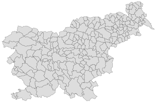
Slovenia is divided into 212 municipalities, of which 12 have urban (metropolitan) status. Municipalities are further divided into local communities and districts.

Halifax is the capital and largest municipality of the Canadian province of Nova Scotia, and the largest municipality in Atlantic Canada. As of the 2021 Census, the municipal population was 439,819, with 348,634 people in its urban area. The regional municipality consists of four former municipalities that were amalgamated in 1996: Halifax, Dartmouth, Bedford, and Halifax County.

Lithuania is divided into three layers of administrative divisions. The first-level division consists of 10 counties. These are sub-divided into 60 municipalities, which in turn are further sub-divided into over 500 smaller groups, known as elderships.

The municipalities are the first level administrative subdivisions of Montenegro. The country is divided into 25 municipalities including the Old Royal Capital Cetinje and the Podgorica Capital City. Podgorica is divided into one subdivision called city municipality, forming the most basic level of local government.

The municipalities and cities are the second level administrative subdivisions of Serbia. The country is divided into 145 municipalities and 29 cities, forming the basic level of local government.

Following the implementation on 1 January 2011 of the Kallikratis Plan, the administrative divisions of Greece consist of two main levels: the regions and the municipalities. In addition, a number of decentralized administrations overseeing the regions exist as part of the Ministry of the Interior, but are not entities of local government. The old prefectures were either abolished and divided or transformed into regional units in 2011. The administrative regions are divided into regional units which are further subdivided into municipalities. The Eastern Orthodox monastic community on Mount Athos is an autonomous self-governing entity.

A direct-administrated municipality, commonly known as municipality, is the highest level of classification for cities used by the People's Republic of China. These cities have the same rank as provinces and form part of the first tier of administrative divisions of China.

Tiruvannamalai is a city, a spiritual, cultural, economic hub and also the administrative headquarters of Tiruvannamalai District in the Indian state of Tamil Nadu. The city is home to the renowned Annamalaiyar temple, Annamalai hill, Girivalam and the Karthigai deepam festival. Being a prominent tourist destination which attracts considerable foreign visitors. The city is one of the cities featured in lonely planet. the city has a thriving service sector industry including retail, resorts and recreation activities. Apart from the service sector, the city is also the hub for many industrial setups including SIDCO, spinning mills and premier educational institutions. The city is administered by the Tiruvanamalai Municipality, originally constituted in the year 1886. The city has a good network of roadways and railways and a popular getaway to the Megacities of Chennai and Bengaluru. The Union Ministry of Civil Aviation is considering setting up a new airport at Tiruvannamalai.


