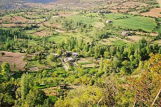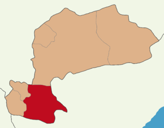
Karaman Province is a province of south-central Turkey. It has an area of 9,163 km2 (3,538 sq mi). A 2010 estimate puts the population at 232,633 people. According to the 2000 census, the population was 243,210. The population density is 27.54 people/km2. The traffic code is 70. The capital is the city of Karaman. Karaman was the location of the Karamanid Beylik, which came to an end in 1486.

Ermenek is a town in Karaman Province in the Mediterranean region of Turkey. It is the seat of Ermenek District. Its population is 11,629 (2022). As ancient Germanicopolis, a former bishopric, it remains a Latin Catholic titular see.

Görmeli is a village in Ermenek District, Karaman Province, Central Anatolia, Turkey. Its population is 544 (2022). It lies on the hillside of Taurus mountains.
Gökçekent is a village in Ermenek District, Karaman Province, Central Anatolia, Turkey. Its population is 839 (2022). The village's old name is Akmanastır.

The Ermenek Dam is a double-curvature concrete arch dam located on the Göksu River in Karaman Province, Turkey. The 210 m (689 ft) tall dam was the highest in Turkey at the time of its construction and currently ranks third after Deriner Dam and Yusufeli Dam. The development was backed by the Turkish State Hydraulic Works. Completed in 2009, the primary purpose of the dam is to support its 300 MW power station.
Güneyyurt is a town (belde) in the Ermenek District, Karaman Province, Turkey. Its population is 4,982 (2022).
Kazancı is a town (belde) in the Ermenek District, Karaman Province, Turkey. Its population is 2,151 (2022). It is situated in Toros Mountains. According to town page the name of the town may refer to Kazancıklı region in Balkan Province of Turkmenistan from where the original residents of the town migrated.
Ardıçkaya is a village in Ermenek District, Karaman Province, Central Anatolia, Turkey. Its population is 955 (2022). It is situated in a high plateau of Taurus Mountains. Distance to Ermenek is 56 kilometres (35 mi) and to Karaman is 200 kilometres (120 mi). The name of the town refers to junipers around the village. The old name of the village is Nadire.
Mecidiye is a village in Keşan District of Edirne Province, Turkey. Its population is 840 (2022). Mecidiye is close to the Gulf of Saros. The distance to Keşan is 28 kilometres (17 mi). The settlement was founded by the Muslim refugees of the Russo-Turkish War (1877-1878). Before the 2013 reorganisation, it was a town (belde). Major economic activities of the town are fishing, beekeeping and farming. Tourism is also promising.
Elmalı is a village in Uzunköprü District of Edirne Province, Turkey. Its population is 732 (2022). It is situated in the Eastern Thrace plains. The distance to Uzunköprü is 20 kilometres (12 mi). The old name of this village is Ermeniköy. It was a Bulgarian village during the Ottoman Empire era. But after the Second Balkan War the Bulgarian population was forced to leave the settlement.
Bayramlı is a village in Uzunköprü District of Edirne Province, Turkey. Its population is 339 (2022). It is situated in the Eastern Thrace plains. The distance to Uzunköprü is 15 kilometres (9.3 mi). The old name of this village was Tarnovo (Търново) or Tırnova. It was a big Bulgarian village during the Ottoman Empire era. But after the Second Balkan War the Bulgarian population was forced to leave the settlement.
Balkusan is a village in Ermenek District, Karaman Province, Central Anatolia, Turkey. Its population is 171 (2022). It is situated in a high plateau of the Taurus Mountains. Distance to Ermenek is 22 kilometres (14 mi).
İkizçınar is a village in Ermenek District, Karaman Province, Central Anatolia, Turkey. Its population is 244 (2022).
Ala Bridge is a historic bridge in Turkey. It is still in use.

Yerköprü Waterfall is a waterfall in Mersin Province, southern Turkey. It is a registered natural monument.
Bucakkışla is a village in Karaman District of Karaman Province, Turkey. Its population is 145 (2022).
Tepebaşı is a village in Ermenek District, Karaman Province, Central Anatolia, Turkey. Its population is 374 (2022).
Elmayurdu is a village in Ermenek District, Karaman Province, Central Anatolia, Turkey. Its population is 454 (2022).
Balabolu is a hill and an archaeological site on the hill in Mersin Province, Turkey.

Ermenek District is a district of the Karaman Province of Turkey. Its seat is the town of Ermenek. Its area is 1,242 km2, and its population is 27,776 (2022). The district forms the core of the plateau region Taşeli.


