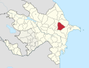
Çay Qurbançı

Last updated

Coordinates: 40°36′39″N49°00′22″E / 40.61083°N 49.00611°E / 40.61083; 49.00611

Geographic coordinate system Coordinate system

A geographic coordinate system is a coordinate system that enables every location on Earth to be specified by a set of numbers, letters or symbols. The coordinates are often chosen such that one of the numbers represents a vertical position and two or three of the numbers represent a horizontal position; alternatively, a geographic position may be expressed in a combined three-dimensional Cartesian vector. A common choice of coordinates is latitude, longitude and elevation. To specify a location on a plane requires a map projection.

Çay Qurbançı
Azerbaijan adm location map.svg
Red pog.svg
Çay Qurbançı
Coordinates: 40°36′39″N49°00′22″E / 40.61083°N 49.00611°E / 40.61083; 49.00611
CountryFlag of Azerbaijan.svg  Azerbaijan
Rayon Gobustan
Municipality Qurbançı
Time zone AZT (UTC+4)
  Summer (DST) AZT (UTC+5)

Çay Qurbançı (also, Chay Kurbanchy and Chaykurabanchi) is a village in the Gobustan Rayon of Azerbaijan. The village forms part of the municipality of Qurbançı. [1]

Azerbaijan Republic in Western Asia and Eastern Europe

Azerbaijan, officially the Republic of Azerbaijan, is a country in the South Caucasus region of Eurasia at the crossroads of Eastern Europe and Western Asia. It is bounded by the Caspian Sea to the east, Russia to the north, Georgia to the northwest, Armenia to the west and Iran to the south. The exclave of Nakhchivan is bounded by Armenia to the north and east, Iran to the south and west, and has an 11 km long border with Turkey in the northwest.

Qurbançı Municipality in Gobustan, Azerbaijan

Qurbançı is a village and municipality in the Gobustan Rayon of Azerbaijan. It has a population of 694. The municipality consists of the villages of Qurbançı and Çay Qurbançı.

Related Research Articles

Makenis Place in Gegharkunik, Armenia

Makenis is a town in the Gegharkunik Province of Armenia. The Makenyats Vank in the town was a major cultural and educational center of medieval Gegharkunik, with structures dating from the 9th to 13th centuries.

Pirəkəşkül Place in Absheron, Azerbaijan

Perekeshkul is a village in the Absheron Rayon of Azerbaijan. The village forms part of the municipality of Pirəkəşkül-Qobustan.

Xumarta Place in Lachin, Azerbaijan

Xumarta is a village in the Lachin Rayon of Azerbaijan.

Çay Tumas Place in Qubadli

Çay Tumas is a village in the Qubadli Rayon of Azerbaijan.

Əvəcükoba Place in Khachmaz, Azerbaijan

Əvəcükoba is a village in the Khachmaz Rayon of Azerbaijan.

Yaşma Place in Khizi, Azerbaijan

Yaşma is a village in the Khizi Rayon of Azerbaijan. The village forms part of the municipality of Şuraabad.

Qars Place in Khizi, Azerbaijan

Qars is a former village in the Khizi Rayon of Azerbaijan. The village formed part of the municipality of Tıxlı.

Yarımca, Khizi Place in Khizi, Azerbaijan

Yarımca is a village in the Khizi Rayon of Azerbaijan. The village forms part of the municipality of Altıağac.

Upa, Azerbaijan Place in Khizi, Azerbaijan

Upa is a village in the Khizi Rayon of Azerbaijan.

Germiyan, Azerbaijan Place in Khizi, Azerbaijan

Germiyan is a village in the Khizi Rayon of Azerbaijan.

Tudar, Azerbaijan Place in Khizi, Azerbaijan

Tudar is a village in the Khizi Rayon of Azerbaijan. The village forms part of the municipality of Ağdərə.

Dizəvər Place in Khizi, Azerbaijan

Dizəvər is a village in the Khizi Rayon of Azerbaijan. The village forms part of the municipality of Qarabulaq.

Gródek is a village in the administrative district of Gmina Grybów, within Nowy Sącz County, Lesser Poland Voivodeship, in southern Poland.

Maarif, Azerbaijan Place in Gadabay, Azerbaijan

Maarif is a village in the Gadabay Rayon of Azerbaijan. The village forms part of the municipality of Slavyanka.

Bəydəmirli is a village in the municipality of Çay Rəsullu in the Gadabay Rayon of Azerbaijan.

Kəcavənd is a village in the municipality of Yanıqlı in the Tovuz Rayon of Azerbaijan.

Kocikowa Village in Silesian, Poland

Kocikowa is a village in the administrative district of Gmina Pilica, within Zawiercie County, Silesian Voivodeship, in southern Poland. It lies approximately 4 kilometres (2 mi) west of Pilica, 15 km (9 mi) east of Zawiercie, and 50 km (31 mi) north-east of the regional capital Katowice.

Chwarzenko Village in Pomeranian, Poland

Chwarzenko is a village in the administrative district of Gmina Stara Kiszewa, within Kościerzyna County, Pomeranian Voivodeship, in northern Poland. It lies approximately 4 kilometres (2 mi) north-west of Stara Kiszewa, 16 km (10 mi) south-east of Kościerzyna, and 52 km (32 mi) south-west of the regional capital Gdańsk.

Coalfields No. 4 is a rural municipality in the Canadian province of Saskatchewan. It is located in southeastern Saskatchewan and is within SARM Division No. 1 and Census Division No. 1. Its population was 396 as of the 2006 Census.

Mäo, Järva County Village in Järva County, Estonia

Mäo is a village in Paide Parish, Järva County in northern-central Estonia.

References

  1. "Belediyye Informasiya Sistemi" (in Azerbaijani). Archived from the original on September 24, 2008.