Deception Pass is a strait separating Whidbey Island from Fidalgo Island, in the northwest part of the U.S. state of Washington. It connects Skagit Bay, part of Puget Sound, with the Strait of Juan de Fuca. A pair of bridges known collectively as Deception Pass Bridge cross Deception Pass. The bridges were added to the National Register of Historic Places in 1982.

The Glorieuses or Glorioso Islands are a group of islands and rocks totaling 5 square kilometres (1.9 sq mi). They are controlled by France as part of the Scattered Islands in the Indian Ocean in the French Southern and Antarctic Lands, a French overseas territory, but are also claimed by Comoros, Madagascar and formerly by Seychelles. They are geographically part of the Comoro Islands between the French overseas region of Mayotte and the nation of Madagascar.
The Kerguelen Islands, also known as the Desolation Islands, are a group of islands in the sub-Antarctic region. They are among the most isolated places on Earth, with the closest territory being the Heard Island and McDonald Islands territory of Australia located at roughly 450 km (240 nmi), and the nearest inhabited territory being Madagascar at more than 3,300 kilometres in distance. The islands, along with Adélie Land, the Crozet Islands, Amsterdam and Saint Paul islands, and France's Scattered Islands in the Indian Ocean, are part of the French Southern and Antarctic Lands and are administered as a separate district.

Lindisfarne, also known as Holy Island, is a tidal island off the northeast coast of England, which constitutes the civil parish of Holy Island in Northumberland. Holy Island has a recorded history from the 6th century AD; it was an important centre of Celtic Christianity under Saints Aidan, Cuthbert, Eadfrith, and Eadberht of Lindisfarne. The island was originally home to a monastery, which was destroyed during the Viking invasions but re-established as a priory following the Norman Conquest of England. Other notable sites built on the island are St Mary the Virgin parish church, Lindisfarne Castle, several lighthouses and other navigational markers, and a complex network of lime kilns. In the present day, the island is an Area of Outstanding Natural Beauty and a hotspot for historical tourism and bird watching. As of February 2020, the island had three pubs, a hotel and a post office as well as a museum.
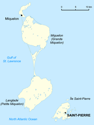
Saint Pierre and Miquelon is a French overseas collectivity in the Western Hemisphere and the Northern Hemisphere. It consists of an island archipelago, off the coast of Newfoundland, near North America. The collectivity shares a maritime boundary with Canada.

The Magdalen Islands are an archipelago in the Gulf of St. Lawrence. Since 2005, the 12-island archipelago is divided into two municipalities: the majority-francophone Municipality of Îles-de-la-Madeleine and the majority-anglophone Municipality of Grosse-Île, in the Gaspésie–Îles-de-la-Madeleine region, Quebec, Canada.
Deception Pass is a strait separating Whidbey Island from Fidalgo Island, in the northwest part of the U.S. state of Washington. It connects Skagit Bay, part of Puget Sound, with the Strait of Juan de Fuca. A pair of bridges known collectively as Deception Pass Bridge cross Deception Pass. The bridges were added to the National Register of Historic Places in 1982.
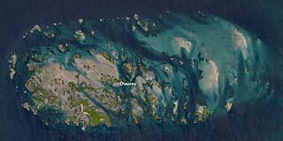
Chausey is a group of small islands, islets and rocks off the coast of Normandy, in the English Channel. It lies 17 kilometres (11 mi) from Granville and forms a quartier of the Granville commune in the Manche département.

Belnahua is one of the Slate Islands, in the Firth of Lorn in Scotland, known for its deserted slate quarries. The bedrock that underpins its human history is part of the Scarba Conglomerate Formation and its value has been on record since the 16th century. Likely uninhabited before commercial quarrying commenced, under the control of the Stevenson family during the 19th century the population expanded to over 150 before the island was abandoned again in 1914.

A tidal island is a raised area of land within a waterbody, which is connected to the larger mainland by a natural isthmus or man-made causeway that is exposed at low tide and submerged at high tide, causing the land to switch between being a promontory/peninsula and an island depending on tidal conditions.

Chapel Island is a limestone outcrop that lies in the Leven estuary of Morecambe Bay in England, less than one mile (1.6 km) from the shoreline at Bardsea in the area known as Ulverston Sands. It is located at 54.1741°N 3.0416°W. It is one of the Islands of Furness in the county of Cumbria, in the area of the historic county of Lancashire. The island is approximately 450 yards (410 m) long and just over 100 yards (91 m) at its widest. Its area is about 7.5 acres.

Mingan Archipelago National Park Reserve or Mingan Archipelago Heritage Site bathes in the waters of the Gulf of St. Lawrence, in the administrative region of Côte-Nord, in Minganie RCM, Havre-Saint-Pierre municipality, facing Anticosti Island.
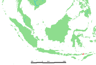
Lembata is an island in the Lesser Sunda Islands, also known as Lomblen island; it is the largest island of the Solor Archipelago, in the Lesser Sunda Islands, Indonesia. It forms a separate regency of the province of Nusa Tenggara Timur. The island has a very irregular coastline with numerous bays and promontories, of which the largest is the Ile Ape peninsula on the island's north coast. The length of the island is about 80 km from the southwest to the northeast and the width is about 30 km from the west to the east. It rises to an elevation of 1,621 metres at Mount Ile Labalekang.

Seaton Sluice is a village in Northumberland. It lies on the coast at the mouth of the Seaton Burn, midway between Whitley Bay and Blyth. In the 2021 census the village had a population of 2,956.

Carantec is a commune in the Finistère department of Brittany in north-western France.

Île Longue is a peninsula of the roadstead of Brest in the department of Finistère in the Brittany region. It is the base of the French nuclear ballistic missile submarines, and as such one of the most secretive and heavily defended places in France.
The Islets of Mauritius include circa 130 tiny islets and rocks scattered around the coast of Mauritius, Rodrigues, Agalega and St Brandon.

Tristan Island or the Île Tristan is located at the mouth of the Pouldavid Estuary off the French port of Douarnenez in south-western Brittany. It is only about 450 m long and 250 m wide but despite its small size, it has a rich history. It is closely associated with Breton legends and the lost island of Ys. In the Middle Ages a priory was built there and the island was inhabited through much of the 20th century. In the 19th century, it became famous as the site of the first canning factory for sardines fished in the Bay of Douarnenez, the beginning of the sardine industry which was important for this region.

Île-Grande is an island on the north coast of Brittany (France), linked to the mainland by a road. Its size is about 2 km by 1 km, and there is a village on the island. It is in the commune of Pleumeur-Bodou.

Île aux Fouquets is an island off the south-east coast of Mauritius.