Bielsko-Biala Voivodeship was a unit of administrative division and local government in Poland from 1975 to 1998, superseded by Silesian Voivodeship and Lesser Poland Voivodeship. Its capital city was Bielsko-Biała.

Leszczawka is a village in the administrative district of Gmina Bircza, within Przemyśl County, Subcarpathian Voivodeship, in south-eastern Poland. It lies approximately 8 kilometres (5 mi) south-west of Bircza, 31 km (19 mi) south-west of Przemyśl, and 53 km (33 mi) south-east of the regional capital Rzeszów.

The Duchy of Zator was one of many Duchies of Silesia.

Nowa Wieś is a village in the administrative district of Gmina Kęty, within Oświęcim County, Lesser Poland Voivodeship, in southern Poland. It lies approximately 1 kilometre (1 mi) north of Kęty, 16 km (10 mi) south of Oświęcim, and 55 km (34 mi) west of the regional capital Kraków.

Głębowice is a village in the administrative district of Gmina Osiek, within Oświęcim County, Lesser Poland Voivodeship, in southern Poland. It lies approximately 5 kilometres (3 mi) east of Osiek, 14 km (9 mi) south-east of Oświęcim, and 46 km (29 mi) west of the regional capital Kraków.
Łazy is a village in the administrative district of Gmina Oświęcim, within Oświęcim County, Lesser Poland Voivodeship, in southern Poland. It lies approximately 8 kilometres (5 mi) south of Oświęcim and 49 km (30 mi) west of the regional capital Kraków.

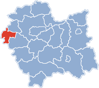
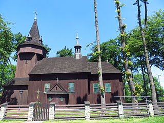
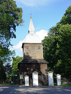
Graboszyce is a village in the administrative district of Gmina Zator, within Oświęcim County, Lesser Poland Voivodeship, in southern Poland. It lies approximately 6 kilometres (4 mi) south of Zator, 20 km (12 mi) south-east of Oświęcim, and 38 km (24 mi) west of the regional capital Kraków.
Grodzisko is a village in the administrative district of Gmina Zator, within Oświęcim County, Lesser Poland Voivodeship, in southern Poland. It lies approximately 5 kilometres (3 mi) south of Zator, 19 km (12 mi) south-east of Oświęcim, and 36 km (22 mi) west of the regional capital Kraków.
Laskowa is a village in the administrative district of Gmina Zator, within Oświęcim County, Lesser Poland Voivodeship, in southern Poland. It lies approximately 3 kilometres (2 mi) south-east of Zator, 19 km (12 mi) south-east of Oświęcim, and 35 km (22 mi) west of the regional capital Kraków.
Palczowice is a village in the administrative district of Gmina Zator, within Oświęcim County, Lesser Poland Voivodeship, in southern Poland. It lies approximately 17 km (11 mi) east of Oświęcim and 36 km (22 mi) west of the regional capital Kraków.
Podolsze is a village in the administrative district of Gmina Zator, within Oświęcim County, Lesser Poland Voivodeship, in southern Poland. It lies approximately 3 kilometres (2 mi) north of Zator, 15 km (9 mi) east of Oświęcim, and 37 km (23 mi) west of the regional capital Kraków.
Rudze is a village in the administrative district of Gmina Zator, within Oświęcim County, Lesser Poland Voivodeship, in southern Poland. It lies approximately 2 kilometres (1 mi) south-east of Zator, 18 km (11 mi) south-east of Oświęcim, and 36 km (22 mi) west of the regional capital Kraków.
Smolice is a village in the administrative district of Gmina Zator, within Oświęcim County, Lesser Poland Voivodeship, in southern Poland. It lies approximately 5 kilometres (3 mi) north-east of Zator, 17 km (11 mi) east of Oświęcim, and 34 km (21 mi) west of the regional capital Kraków.
Trzebieńczyce is a village in the administrative district of Gmina Zator, within Oświęcim County, Lesser Poland Voivodeship, in southern Poland. It lies approximately 3 kilometres (2 mi) south-east of Zator, 19 km (12 mi) south-east of Oświęcim, and 35 km (22 mi) west of the regional capital Kraków.
Lipowiec was a village in the administrative district of Gmina Jaśliska, within Krosno County, Subcarpathian Voivodeship, in south-eastern Poland, close to the border with Slovakia. It lies approximately 19 kilometres (12 mi) south of Dukla, 31 km (19 mi) south of Krosno, and 71 km (44 mi) south of the regional capital Rzeszów.
Polanka Wielka is a village in Oświęcim County, Lesser Poland Voivodeship, in southern Poland. It is the seat of the gmina called Gmina Polanka Wielka. It lies approximately 10 kilometres (6 mi) south-east of Oświęcim and 46 km (29 mi) west of the regional capital Kraków.
Kierzki is a settlement in the administrative district of Gmina Włoszakowice, within Leszno County, Greater Poland Voivodeship, in west-central Poland. It lies approximately 6 kilometres (4 mi) north-east of Włoszakowice, 18 km (11 mi) north-west of Leszno, and 59 km (37 mi) south-west of the regional capital Poznań.

Stradunia is a village in the administrative district of Gmina Walce, within Krapkowice County, Opole Voivodeship, in south-western Poland. It lies approximately 6 kilometres (4 mi) north-east of Walce, 9 km (6 mi) south-east of Krapkowice, and 30 km (19 mi) south of the regional capital Opole.