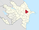
Şorsulu, Gobustan

Last updated

Coordinates: 40°28′N48°57′E / 40.467°N 48.950°E / 40.467; 48.950

Geographic coordinate system Coordinate system

A geographic coordinate system is a coordinate system that enables every location on Earth to be specified by a set of numbers, letters or symbols. The coordinates are often chosen such that one of the numbers represents a vertical position and two or three of the numbers represent a horizontal position; alternatively, a geographic position may be expressed in a combined three-dimensional Cartesian vector. A common choice of coordinates is latitude, longitude and elevation. To specify a location on a plane requires a map projection.

Şorsulu
Azerbaijan adm location map.svg
Red pog.svg
Şorsulu
Coordinates: 40°28′N48°57′E / 40.467°N 48.950°E / 40.467; 48.950
CountryFlag of Azerbaijan.svg  Azerbaijan
Rayon Gobustan
Time zone AZT (UTC+4)
  Summer (DST) AZT (UTC+5)

Şorsulu (also, Shorsulu) is a village in the Gobustan Rayon of Azerbaijan.

Azerbaijan Republic in Western Asia and Eastern Europe

Azerbaijan, officially the Republic of Azerbaijan, is a country in the South Caucasus region of Eurasia at the crossroads of Eastern Europe and Western Asia. It is bounded by the Caspian Sea to the east, Russia to the north, Georgia to the northwest, Armenia to the west and Iran to the south. The exclave of Nakhchivan is bounded by Armenia to the north and east, Iran to the south and west, and has an 11 km long border with Turkey in the northwest.

Related Research Articles

Uhliská municipality of Slovakia

Uhliská is a village and municipality in the Levice District in the Nitra Region of Slovakia.

Kharko Place in Davachi, Azerbaijan

Kharko is a village in the Davachi Rayon of Azerbaijan.

Bığır, Ismailli Place in Ismailli, Azerbaijan

Bığır is a village in the Ismailli Rayon of Azerbaijan.

Valasin Place in Ismailli, Azerbaijan

Valasin is a village in the Ismailli Rayon of Azerbaijan.

Həmyəli, Gobustan Place in Gobustan, Azerbaijan

Cır Təklə is a village in the Gobustan Rayon of Azerbaijan.

Damlamaca Place in Gobustan, Azerbaijan

Damlamaca is a former village in the Gobustan Rayon of Azerbaijan. The village formed part of the municipality of Cəmcəmli.

Şıxlar, Gobustan Place in Gobustan, Azerbaijan

Şıxlar is a former village in the Gobustan Rayon of Azerbaijan. The village formed part of the municipality of Xilmilli.

Novonikolayevka, Azerbaijan Place in Quba, Azerbaijan

Novonikolayevka is a village in the Quba Rayon of Azerbaijan. The village forms part of the municipality of Hacıhüseynli.

Qırlar Place in Agsu, Azerbaijan

Qırlar is a village in the Agsu Rayon of Azerbaijan. The village forms part of the municipality of Nüydü.

Qarabulaq, Gobustan Place in Gobustan, Azerbaijan

Qarabulaq is a village in the Gobustan Rayon of Azerbaijan.

Brzeźnica, Bochnia County Village in Lesser Poland, Poland

Brzeźnica is a village in the administrative district of Gmina Bochnia, within Bochnia County, Lesser Poland Voivodeship, in southern Poland. It lies approximately 5 kilometres (3 mi) south-east of Bochnia and 40 km (25 mi) east of the regional capital Kraków.

Sədəfli is a village and municipality in the Gobustan Rayon of Azerbaijan. It has a population of 300.

Üzümçü is a village in the municipality of Bədəlli in the Gobustan Rayon of Azerbaijan.

Aşkar is a village in the municipality of Quşçu in the Shamakhi Rayon of Azerbaijan.

Szászfa is a village in Borsod-Abaúj-Zemplén County in northeastern Hungary.

Tenang Stesen human settlement in Malaysia

Tenang Stesen, commonly known as “Tenang”, is a small town in Segamat District, Johor, Malaysia. The town is located between Genuang and Labis. Note that Pekan Air Panas located at the same district also named as Tenang.

Gorno Egri is an abandoned village in the Bitola Municipality of Macedonia

Kuşkara is a village in the District of Kastamonu, Kastamonu Province, Turkey.

References