Żarki

Last updated • 3 min readFrom Wikipedia, The Free Encyclopedia
Żarki
Zarki fontanna.JPG
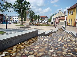
Town square
POL Zarki COA.svg
Poland adm location map.svg
Red pog.svg
Żarki
Coordinates: 50°37′41″N19°22′13″E / 50.62806°N 19.37028°E / 50.62806; 19.37028
Country Flag of Poland.svg  Poland
Voivodeship Silesian
County Myszków
Gmina Żarki
Area
  Total
25.68 km2 (9.92 sq mi)
Population
 (2019-06-30 [1] )
  Total
4,556
  Density180/km2 (460/sq mi)
Postal code
42-310
Website http://www.umigzarki.pl/

Żarki [ˈʐarki] (German : Zarki) is a town in Myszków County, Silesian Voivodeship, Poland, with 4,556 inhabitants (2019). The history of Żarki dates back to the early 14th century, as the village was first mentioned in documents from the 1320s. For centuries, Żarki belonged to Lelow County, Kraków Voivodeship, historic province of Lesser Poland.

Contents

History

It is not known when the village of Żarki received town charter: it happened before 1382, most likely during the reign of King Casimir III the Great. By 1406, Żarki already was a well established private town, governed by a vogt. Żarki belonged to several noble families, and was a local centre of craft and trade. In 1556, fairs were established on every Tuesday. Żarki had a market square, and its population in 1662 reached 620 residents. In 1664, the town burned in a great fire.

In 1720, Żarki was moved to a new location. At that time, the town became a center of iron ore mining, with a blast furnace. By 1791, its population grew to over 1200, and in 1793, the town was annexed by the Kingdom of Prussia (see Partitions of Poland). In 1807, Żarki became part of the Duchy of Warsaw, and in 1815, Russian-controlled Congress Poland, in which it remained until World War I. Due to efforts of Piotr Steinkeller, Żarki was an industrial center, where agricultural machinery was manufactured. In the 1850s, a cotton plant was opened here as well. Following the January Uprising, Żarki lost its town charter.

In 1914, the population of Żarki was app. 5000. During the month of October 1918, a short-lived local post was organized by the officer in charge of Civil Affairs of the District of Dabrow. [2]

In the Second Polish Republic, Żarki belonged to Zawiercie County of Kielce Voivodeship. On September 4, 1939, Żarki was burned to the ground by the Wehrmacht. They shot more than 100 residents, most of whom were Jewish. Other Jews were robbed and many were conscripted for forced labor. Later, in late 1941 or early 1942, Jews, including those who had been deported to Zarki, were forced into an overcrowded ghetto without much access to food and medical care. Some young Jews were able to establish a small farm which provided vegetables, fruits, and fish to the Jewish residents. In October 1942, the Germans ordered Polish farmers to bring horses and wagons to the ghetto. Around 800 Jews were rounded up by the German SS, Ukrainian auxiliaries, and Polish police. Those in hiding who were caught were shot. The Polish farmers took the Jews to the train station in Zloty Potok and from there they were taken in freight cars to Treblinka where they were immediately murdered. About 1600 other Jews had fled when they heard the news that the Polish farmers had been ordered to come to the ghetto. Most fled to other ghettos and most eventually were murdered in killing camps. The number of Żarki Jews who survived the war and Holocaust is unknown. [3]

In 1949, Żarki regained its town charter.

Demographics

YearTotal populationJewish populationPercentage of total population
1741113 of adults
1791348
18272.57170227.3%
18571.544
18643.7562.29161%
18972.250
19095.1942.32744.8%
19214.0732.53657.6%
20084.363

Historic sites

Among local points of interest there are:

Related Research Articles

<span class="mw-page-title-main">Sucha Beskidzka</span> Place in Lesser Poland Voivodeship, Poland

Sucha Beskidzka is a town in the Żywiec Beskids mountain range in southern Poland, on the Skawa river. It is the county seat of Sucha County. It has been in the Lesser Poland Voivodeship since 1999; previously it was in Bielsko-Biała Voivodeship (1975–1998).

<span class="mw-page-title-main">Hrubieszów</span> Place in Lublin Voivodeship, Poland

Hrubieszów is a town in southeastern Poland, with a population of around 18,212 (2016). It is the capital of Hrubieszów County within the Lublin Voivodeship.
<span class="mw-page-title-main">Czeladź</span> Place in Silesian Voivodeship, Poland

Czeladź is a town in Zagłębie Dąbrowskie, in southern Poland, near Katowice and Sosnowiec. Located in the Silesian Highlands, on the Brynica river, it is the oldest urban center of Zagłębie Dąbrowskie. The area of Czeladź is 16 km2, and it borders Będzin, Sosnowiec, Katowice and Siemianowice Śląskie.

<span class="mw-page-title-main">Zawiercie</span> Place in Silesian Voivodeship, Poland

Zawiercie ( ) is a town in southern Poland located in the Silesian Voivodeship with 49,334 inhabitants (2019). It is situated in the Kraków-Częstochowa Upland near the source of the Warta River. The town lies near the historical region of Silesia, but belongs to Lesser Poland.

<span class="mw-page-title-main">Opole Lubelskie</span> Place in Lublin Voivodeship, Poland

Opole Lubelskie is a town in southeastern Poland. As of 2004, it had 8,879 inhabitants. The town is situated in Lublin Voivodeship, some 10 kilometers east of the Vistula River, and is the capital of Opole Lubelskie County. It was founded in the 14th century, and historically belongs to Lublin Land, which is part of Lesser Poland.

<span class="mw-page-title-main">Kazimierz Dolny</span> Place in Lublin Voivodeship, Poland

Kazimierz Dolny is a small historic town in eastern Poland, on the right (eastern) bank of the Vistula river in Puławy County, Lublin Voivodeship. Historically it belongs to Lesser Poland, and in the past it was one of the most important cities of the province.

<span class="mw-page-title-main">Gąbin</span> Place in Masovian Voivodeship, Poland

Gąbin is a small town in Płock County, Masovian Voivodeship, Poland, with 4,065 inhabitants as of December 2021. The Warsaw radio mast, which stood near Gąbin, was the tallest structure in the world until its collapse in 1991. It remained the highest structure ever created till 2010.
<span class="mw-page-title-main">Dukla</span> Town in Subcarpathian Voivodeship, Poland

Dukla is a town and an eponymous municipality in southeastern Poland, in the Subcarpathian Voivodeship. As of December 2021, the town has a population of 2,017. The total area of the commune is 333.04 square kilometres (128.59 sq mi). Dukla belongs to Lesser Poland, and until the Partitions of Poland it was part of Biecz County, Kraków Voivodeship.

<span class="mw-page-title-main">Bełżyce</span> Place in Lublin Voivodeship, Poland

Bełżyce is a town in eastern Poland, in the Lublin Voivodeship, in Lublin County, and about 20 km (12 mi) to the west of the city of Lublin. Bełżyce belongs to the historical region of Lesser Poland. As of December 2021, the town has a population of 6,290.

<span class="mw-page-title-main">Kock</span> Place in Lublin Voivodeship, Poland

Kock is a town in eastern Poland, about 45 kilometres north of Lublin and 120 kilometres south-east of Warsaw. It lies in Lublin Voivodeship, in Lubartów County. It is the capital of the administrative district Gmina Kock. Historically Kock belongs to the Polish province of Lesser Poland and is located in its northeastern corner. As of 2004, its population numbered 3,509.
<span class="mw-page-title-main">Lipsko</span> Place in Masovian Voivodeship, Poland

Lipsko is a town in eastern Poland, in northern Lesser Poland, Masovian Voivodeship. It is the capital of Lipsko County. The population is 5,895 (2004). Lipsko’s coat of arms is the Dębno, which was used by previous owners of the town.

<span class="mw-page-title-main">Iłża</span> Place in Masovian Voivodeship, Poland

Iłża is a small town in Masovian Voivodeship, Poland. In 2006 Iłża had approximately 5,165 inhabitants. The town belongs to the historical region of Lesser Poland, and from its foundation until 1795, it was part of Lesser Poland’s Sandomierz Voivodeship. Iłża lies in Małopolska Upland, on the Iłżanka river, 30 kilometers south of Radom.

<span class="mw-page-title-main">Bychawa</span> Place in Lublin Voivodeship, Poland

Bychawa is a town in southeastern Poland, in Lublin Voivodeship, in Lublin County, about 25 km south of Lublin. The town lies in Lublin Upland and belongs to historic Lesser Poland. The town was first mentioned in historical documents from the 14th century and first received its city charter in 1537. The charter was lost in 1869, causing the town to revert to village status, but the charter was regained in 1958. In 1956–1975 Bychawa was the seat of Bychawa County. The town has the area of 6.69 square kilometres (2.58 sq mi), and as of December 2021 it has 4,757 inhabitants.
<span class="mw-page-title-main">Tyszowce</span> Place in Lublin Voivodeship, Poland

Tyszowce is a town in Tomaszów Lubelski County, Lublin Voivodeship, Poland, with 359 inhabitants (2004). Tyszowce was incorporated as a town from 1419 until 1870 when it lost its city charter, to regain it only in 2000. In 1655 the Tyszowce Confederation was formed here.

<span class="mw-page-title-main">Bodzentyn</span> Place in Świętokrzyskie Voivodeship, Poland

Bodzentyn is a town in Kielce County, Świętokrzyskie Voivodeship, Poland, with 2,168 inhabitants as of December 2021. Bodzentyn belongs to Lesser Poland, and was granted town charter in 1355. The town lies in the Świętokrzyskie Mountains, here main office of the Świętokrzyski National Park is located.
<span class="mw-page-title-main">Ćmielów</span> Place in Świętokrzyskie Voivodeship, Poland

Ćmielów is a town in Ostrowiec County, Świętokrzyskie Voivodeship, Poland, seat of Gmina Ćmielów. As of December 2021, it has 2,954 inhabitants. It is known for one of Poland's oldest porcelain factories dating back to 1790. The town history dates back to 14th century. It has several tourist attractions, in addition to its old porcelain factory, including ruins of a 16th-century castle and a church from the same period. Ćmielów belongs to Lesser Poland, and lies on the Kamienna river in the Sandomierz Upland, 10 kilometers east of Ostrowiec Świętokrzyski, along local road nr. 755.

<span class="mw-page-title-main">Chęciny</span> Place in Świętokrzyskie Voivodeship, Poland

Chęciny is a town in Kielce County, Świętokrzyskie Voivodeship, southern Poland, with 4,361 inhabitants as of December 2021. It was first mentioned in historical documents from 1275, and obtained its city charter in 1325. At that time was one of major urban centers of northern Lesser Poland.

<span class="mw-page-title-main">Działoszyce</span> Place in Świętokrzyskie Voivodeship, Poland

Działoszyce is a town in Świętokrzyskie Voivodeship, Poland, with 2882 inhabitants as of December 2023.

<span class="mw-page-title-main">Sokołów Małopolski</span> Place in Subcarpathian Voivodeship, Poland

Sokołów Małopolski is a town in Rzeszów County, Subcarpathian Voivodeship, Poland, with a population of 3,962 (2 June 2009).

<span class="mw-page-title-main">Złoczew</span> Place in Łódź Voivodeship, Poland

Złoczew is a town in Sieradz County, Łódź Voivodeship, Poland, with 3,340 inhabitants (2020). The city is 23 kilometres south of Sieradz and 23 kilometres north of Wieluń.
References

  1. "Population. Size and structure and vital statistics in Poland by territorial division in 2019. As of 30th June". stat.gov.pl. Statistics Poland. 2019-10-15. Retrieved 2020-03-13.
  2. Poland 1918 Locals. England: J. Barefoot Ltd. 1999. pp. 42–45. ISBN   0-906845-55-6.
  3. m, Geoffrey (2012). Encyclopedia of Camps and Ghettos. Bloomington, Indiana: University of Indiana Press. p. Volume II 349–350. ISBN   978-0-253-35599-7.