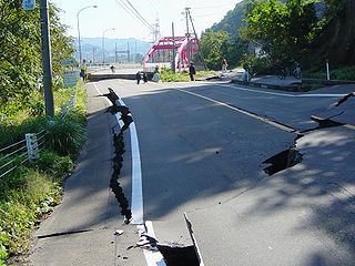
The Chūetsu earthquakes occurred in Niigata Prefecture, Japan, at 17:56 local time on Saturday, October 23, 2004. The Japan Meteorological Agency (JMA) named it the "Heisei 16 Niigata Prefecture Chuetsu Earthquake". Niigata Prefecture is located in the Hokuriku region of Honshu, the largest island of Japan. The initial earthquake had a magnitude of 6.6 and caused noticeable shaking across almost half of Honshu, including parts of the Tōhoku, Hokuriku, Chūbu, and Kantō regions.
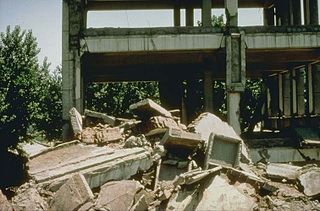
The 1976 Tangshan earthquake was a 7.6 earthquake that hit the region around Tangshan, Hebei, China, at 3:42 a.m. on 28 July 1976. The maximum intensity of the earthquake was XI (Extreme) on the Mercalli scale. In minutes, 85 percent of the buildings in Tangshan collapsed or were rendered unusable, all services failed, and most of the highway and railway bridges collapsed or were seriously damaged. The official report claimed 242,769 deaths and 164,851 serious injuries in Tangshan, but when taken into account the missing, the injured who later died and the deaths in nearby Beijing and Tianjin, scholars accepted at least 300,000 died, making it one of the deadliest earthquakes in recorded history and worst disasters in China by death toll.
The 1556 Shaanxi earthquake, known in Chinese colloquially by its regnal year as the Jiajing Great Earthquake "嘉靖大地震" or officially by its epicenter as the Hua County Earthquake "华县地震", occurred in the early morning of 23 January 1556 in Huaxian, Shaanxi during the Ming dynasty.

The 1920 Haiyuan earthquake occurred on December 16 in Haiyuan County, Ningxia Province, Republic of China at 19:05:53. It was also called the 1920 Gansu earthquake because Ningxia was a part of Gansu Province when the earthquake occurred. It caused destruction in the Lijunbu-Haiyuan-Ganyanchi area and was assigned the maximum intensity on the Mercalli intensity scale. About 258,707~273,407 died, making it one of the most fatal earthquakes in China, in turn making it one of the worst disasters in China by death toll.
The 1918 Shantou earthquake occurred in Shantou, Guangdong, Republic of China. Serious damage and high casualty numbers were reported in Guangdong and the surrounding provinces. It also caused some damage in colonial Hong Kong.

The 1935 Shinchiku-Taichū earthquake occurred with a Richter magnitude of 7.1 (7.0 Mw) in April 1935 with its epicenter in Taichung, Taiwan. It was the deadliest earthquake in Taiwan's recorded history, claiming 3,276 lives and causing extensive damage. Twelve seconds after the mainshock, an aftershock of 6.0 occurred, centered on Gabi Village.
The 1969 Bohai earthquake occurred on July 18, 1969, at 13:24 local time. The epicenter was located in the Bohai Sea, off the coast of Shandong Province, China. The magnitude of this earthquake is 7.4. Areas of maximal intensity were mainly distributed around the estuary of the Yellow River. Ground cracks and sand boils were reported. The earthquake could be felt in Liaoning, Hebei, Beijing, Tianjin, Shanxi, Shandong, and Jiangsu. Ten people were reported dead.
A potent magnitude 6.6 Mw intraplate aftershock occurred at 17:16 JST (08:16 UTC) on 11 April, in the Hamadōri region of Fukushima, Japan. With a shallow focus of 13 km (8.1 mi), the earthquake was centred inland about 36 km (22 mi) west of Iwaki, causing widespread strong to locally severe shaking. It was one of many aftershocks to follow the 11 March Tōhoku earthquake, and the strongest to have its epicentre located inland.
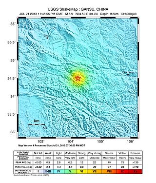
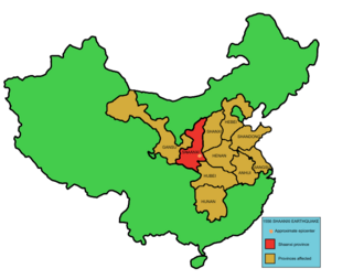
On 22 July 2013, a series of earthquakes occurred in Dingxi, Gansu. The first quake struck at 07:45 China Standard Time with an epicenter located at the border of Min County and Zhang County. The magnitude of the initial earthquake was placed at 6.6 by the China Earthquake Data Center with a focal depth of 20.0 kilometres (12 mi). It was measured at 5.9 by the United States Geological Survey (USGS) and Mw 6.0 by the European Alert System. Another strong quake occurred about one hour later, measuring 5.6 magnitude by the USGS. As of 18:00 CST, 22 July 2013, 422 aftershocks had been recorded. The earthquakes were also felt in the nearby cities of Tianshui and Lanzhou in Gansu, as well as Xi'an, Baoji, and Xianyang in neighbouring Shaanxi.

The 2016 Kumamoto earthquakes were a series of earthquakes, including a magnitude 7.0 mainshock which struck at 01:25 JST on April 16, 2016 beneath Kumamoto City of Kumamoto Prefecture in Kyushu Region, Japan, at a depth of about 10 kilometres (6.2 mi), and a foreshock earthquake with a magnitude 6.2 at 21:26 JST (12:26 UTC) on April 14, 2016, at a depth of about 11 kilometres (6.8 mi).
A major seismic event occurred during the rule of the Qing dynasty in Shandong Province on July 25, 1668. The earthquake had an estimated magnitude of 8.5, making it the largest historical earthquake in East China, and one of the largest to occur on land. The earthquake had cataclysmic implications to the region. An estimated 43,000 to 50,000 lives were lost in the earthquake, and its effects were widely felt. The epicenter may have been located between Ju and Tancheng counties, northeast of the prefecture-level city of Linyi in southern Shandong.
The 1739 Yinchuan–Pingluo earthquake rocked the northern Ningxia Hui Autonomous Region on January 3 with an epicenter in the prefecture-level city Shizuishan. The estimated magnitude 7.1–7.6 earthquake had a maximum intensity of XI on the Mercalli intensity scale, and killed about 50,000 residents and officials. It was widely felt; perceived in Shanxi, Shaanxi and Hebei provinces. Aftershocks persisted for more than two years with the largest being a 5.5 on February 13 that same year.
The 1902 Turkestan earthquake devastated Xinjiang, China, near the Kyrgyzstan border. It occurred on August 22, 1902, at 03:00:22 with an epicenter in the Tien Shan mountains. The thrust earthquake measured 7.7 on the moment magnitude scale (Mw ) and had a depth of 18 km (11 mi).
The 2021 Luxian earthquake was a damaging seismic event occurring in the early hours of September 16 at 04:33 China Standard Time. The surface wave magnitude (Ms ) 6.0 or moment magnitude (Mw ) 5.4 earthquake struck at a shallow depth of 7.5 km and severe shaking in an area of 4,000 square kilometers was assigned a maximum intensity of VIII on the China seismic intensity scale. Three people were killed and 146 injured when the earthquake struck Lu County, Luzhou, Sichuan Province. At least 36,800 buildings were affected, 7,800 of them seriously damaged or completely destroyed, causing about a quarter of a billion dollars worth of damage.

The 1695 Linfen earthquake struck Shanxi Province in North China, Qing dynasty on May 18. Occurring at a shallow depth within the continental crust, the surface-wave magnitude 7.8 earthquake had a maximum intensity of XI on the China seismic intensity scale and Mercalli intensity scale. This devastating earthquake affected over 120 counties across eight provinces of modern-day China. An estimated 52,600 people died in the earthquake, although the death toll may have been 176,365.
Western Henan and southern Shanxi in northern China were struck by an earthquake of estimated magnitude 6.8 on 23 October 1815. The epicentre was in Pinglu County in southernmost Shanxi, which was the worse affected area. It had a maximum felt intensity of IX (violent) on the Modified Mercalli scale. It caused the collapse of many houses and cave dwellings and led to the deaths of at least 13,000 people.
The 1626 Lingqiu earthquake had an epicentre in Lingqiu County, Shanxi Province during the Ming dynasty. The estimated surface wave magnitude (Ms ) 7.0 earthquake caused many buildings to collapse. Over 5,200 people were killed.
The Shanxi Rift System or Fen–Wei Rift System is a zone of active extensional tectonics that forms the eastern margin of the Ordos Block in northern China. The zone extends for at least 900 km (560 mi) and runs south-southwest to north-northeast. The individual rift basins that make up the rift system have an overall en echelon geometry, consistent with a right lateral sense of strike-slip displacement across the zone. The basins contain a thick sedimentary sequence of Neogene age, which ranges from 2.0 to 3.8 km in thickness. The rift system is continuous with the Weihe Basin to the southwest, which became active during the Paleogene. Rupture of the major normal faults that bound the Weihe and Shanxi rift basins has caused many large and damaging historical earthquakes, including the 1303 Hongdong, 1556 Shaanxi, 1626 Lingqiu, 1695 Linfen and 1815 Pinglu events.

A 6.7 earthquake struck Luding County in Sichuan province, China on 5 September 2022 at 12:52:19 local time. The epicenter was located 226 km (140 mi) from Chengdu, or 43 km (27 mi) southeast of Kangding. Ninety-three people died, 424 were injured and 24 remained missing. More than 13,000 homes and other infrastructure were damaged or destroyed. It was the largest earthquake to strike the province since 2017.

