Coulomb stress transfer is a seismic-related geological process of stress changes to surrounding material caused by local discrete deformation events. Using mapped displacements of the Earth's surface during earthquakes, the computed Coulomb stress changes suggest that the stress relieved during an earthquake not only dissipates but can also move up and down fault segments, concentrating and promoting subsequent tremors. Importantly, Coulomb stress changes have been applied to earthquake-forecasting models that have been used to assess potential hazards related to earthquake activity.

The 1920 Haiyuan earthquake occurred on December 16 in Haiyuan County, Ningxia Province, Republic of China at 19:05:53. It was also called the 1920 Gansu earthquake because Ningxia was a part of Gansu Province when the earthquake occurred. It caused destruction in the Lijunbu-Haiyuan-Ganyanchi area and was assigned the maximum intensity on the Mercalli intensity scale. About 258,707-273,407 died, making it one of the deadliest earthquakes in China and disasters in China by death toll.
The 2000 Yunnan earthquake occurred on January 14 at 23:37 UTC, in Yunnan, China. The earthquake killed 7 people, and caused much damage in central Yunnan Province.

The 1970 Tonghai earthquake occurred at with a moment magnitude of 7.1 and a maximum Mercalli intensity of X (Extreme). The strike-slip rupture originated on the Red River Fault, which had not experienced an earthquake above magnitude 7 since 1700, and affected Tonghai County, Yunnan province, China. At least 10,000 people were killed, making it one of the deadliest in its decade. The tremor caused between US$5 and $25 million in damage, felt over an area of 8,781 km2 (3,390 sq mi). In Hanoi, North Vietnam, almost 483 km (300 mi) from the epicenter, victims left their homes as the rupture rumbled through the city.
The 1925 Dali earthquake occurred at 14:42 UTC on 16 March. It had an estimated magnitude of 7.0 on the surface-wave magnitude scale and a maximum perceived intensity of at least IX (Violent) on the Mercalli intensity scale. It had an epicenter in the province of Yunnan in southern China and killed an estimated 5,000 people.
An earthquake occurred on 1 June 1786 in and around Kangding, in what is now China's Sichuan province. It had an estimated magnitude of about 7.75 and a maximum perceived intensity of X (Extreme) on the Mercalli intensity scale. The initial quake killed 435 people. After an aftershock ten days later, a further 100,000 died when a landslide dam collapsed across the Dadu river.

The Xianshuihe fault system or the Yushu-Ganzi-Xianshuihe fault system is a major active sinistral (left-lateral) strike-slip fault zone in southwestern China, at the eastern edge of the Tibetan Plateau. It has been responsible for many major earthquakes, and is one of the most seismically active fault zones in China.

The 2014 Ludian earthquake struck Ludian County, Yunnan, China, with a moment magnitude of 6.1 on 3 August. The earthquake killed at least 615 people, injuring at least 2,400 others. At least 114 people remained missing. Over 12,000 houses collapsed and 30,000 were damaged. According to the United States Geological Survey, the earthquake occurred 29 km (18 mi) west-southwest of Zhaotong city at 16:30 local time (08:30 UTC).
The 2019 Cotabato earthquakes were an earthquake swarm which struck the province of Cotabato on the island of Mindanao in the Philippines in October 2019. Three of these earthquakes were above 6.0 on the moment magnitude scale with a Mercalli intensity of VIII. More than 40 people have been reported dead or missing and nearly 800 were injured as a result of these events.
The 1973 Luhuo earthquake struck near the town of Zhaggo in Garzê Tibetan Autonomous Prefecture of Sichuan Province, China on February 6, 1973, with a magnitude of 7.6 . The earthquake had a maximum intensity of X (Extreme) on the Modified Mercalli intensity scale. It resulted in between 2,175 and 2,204 deaths and a further 2,743 injuries. Serious and widespread destruction occurred in Luhuo County.
The 2020 Qiaojia earthquake occurred in Yunnan, China, 42 km west of Zhaotong on May 18, 21:48 local time. The moment magnitude 5.1 quake occurred at a depth of 10 km. Various buildings were damaged, and one house collapsed in Zhaoyang District. Four people were killed while 24 people were injured.
The 1995 Menglian earthquake or 1995 Myanmar–China earthquake occurred on 12 July at 05:46:43 local time in the Myanmar–China border region. The earthquake had an epicenter on the Myanmar side of the border, located in the mountainous region of Shan State. It registered 7.3 on the Chinese surface wave magnitude scale (Ms ) and 6.8 on the moment magnitude scale (Mw ). With a maximum Mercalli intensity assigned at VIII, it killed 11 people and left another 136 injured. Over 100,000 homes in both countries were destroyed and 42,000 seriously damaged. Some damage to structures were also reported in Chiang Mai and Chiang Rai, Thailand. The low death toll from this earthquake was attributed to an early warning issued prior to it happening. Precursor events including foreshocks and some seismic anomalies led to an evacuation of the area before the mainshock struck. It is thought to be one of the few successfully predicted earthquakes in history.
The 1850 Xichang earthquake rocked Sichuan Province of Qing China on September 12. The earthquake which caused major damage in Xichang county had an estimated moment magnitude of 7.3–7.9 Mw and a surface wave magnitude of 7.5–7.7 Ms . An estimated 20,650 people died.
The 1923 Renda earthquake occurred on March 24 at 20:40 local time between the counties of Daofu and Luhuo in Sichuan, China. The estimated 7.3 earthquake was assigned a maximum modified Mercalli intensity scale rating of X (Extreme). Severe damage occurred in Sichuan, killing an estimated 4,800 people.
The 1955 Zheduotang earthquake, also known as the Kangding earthquake occurred on April 14 at 09:29:02 local time near the city of Kangding in the Garzê Tibetan Autonomous Prefecture, Sichuan. The earthquake had a moment magnitude of 7.0 and a surface wave magnitude of 7.1 and struck at a depth of 10 km. Severe damage occurred in Kangding with the loss of 70 lives.
The 2003 Dayao earthquake occurred on July 21, at 23:16:33 CST. The epicenter of the moment magnitude 5.9 earthquake was in Dayao County in the mountainous area of central Yunnan, China. At least 19 people were killed, 644 were injured, and 8,406 families became homeless. The quake also caused $75 million USD in damage.
On April 11, 1870, a moment magnitude 7.3 earthquake struck Batang County in Sichuan, China. The earthquake had a maximum Modified Mercalli intensity of X (Extreme). The earthquake and a large fire resulted in between 2,300 and 5,000 fatalities.
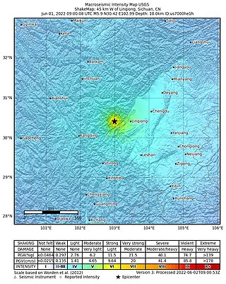
On June 1, 2022, a moment magnitude (Mw ) 5.8 or surface-wave magnitude (Ms ) 6.1 earthquake struck Lushan County in Ya'an, Sichuan Province, China. At least four people were killed and 42 were injured. The earthquake had a maximum intensity of VIII on the China seismic intensity scale, causing damage to many homes and triggering rockslides.

A 6.7 earthquake struck Luding County in Sichuan province, China on 5 September 2022 at 12:52:19 local time. The epicenter was located 226 km (140 mi) from Chengdu, or 43 km (27 mi) southeast of Kangding. Ninety-three people died, 424 were injured and 24 remained missing. More than 13,000 homes and other infrastructure were damaged or destroyed. It was the largest earthquake to strike the province since 2017.
