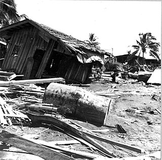
The 1998 Papua New Guinea earthquake occurred on July 17 with a moment magnitude of 7.0 and a maximum Mercalli intensity of VIII (Severe). The event occurred on a reverse fault near the north coast region of Papua New Guinea, 25 kilometers (16 mi) from the coast near Aitape, and caused a large undersea landslide which caused a tsunami that hit the coast, killing between at least 2,183 and 2,700 people and injuring thousands.
The 1976 Moro Gulf earthquake and tsunami occurred on near the islands of Mindanao and Sulu, in the Philippines. It meaured 8.0 on the moment magnitude scale occurring at a depth of 20 km (12 mi). The earthquake was accompanied by a destructive tsunami that resulted in a majority of the estimated 5,000 to 8,000 fatalities. It was the deadliest and strongest earthquake in the Philippines in 58 years since the 1918 Celebes Sea earthquake.

The 2002 Denali earthquake occurred at 22:12:41 UTC November 3 with an epicenter 66 km ESE of Denali National Park, Alaska, United States. This 7.9 Mw earthquake was the largest recorded in the United States in 37 years. The shock was the strongest ever recorded in the interior of Alaska. Due to the remote location, there were no fatalities and only one injury.
The 2000 New Ireland earthquakes occurred off the coast of New Ireland Province, Papua New Guinea on November 16 and 17.
The 2003 Altai earthquake, or 2003 Chuya earthquake, occurred on September 27 at with a moment magnitude of 7.3 and a maximum Mercalli intensity of X (Extreme). The epicenter of this oblique-slip shock was in Altai Republic, Russia near the borders of Mongolia, China, and Kazakhstan. Three deaths and five injuries were reported and the total damage was listed as $10.6–33 million.
The 1996 Biak earthquake, or the Irian Jaya earthquake, occurred on 17 February at near Biak Island, Indonesia. The earthquake, which occurred on the New Guinea Trench, had a moment magnitude of 8.2 and a maximum Mercalli intensity of IX (Violent). The run-up height of the generated tsunami reached 7.7 m (25 ft). The disaster left at least 108 people dead, 423 injured, and 58 missing. It damaged or destroyed 5,043 houses which subsequently made another 10,000 homeless. At Korim, 187 houses were destroyed. Various countries and organizations provided aid and relief in the aftermath of the earthquake.
The 1992 Murindó earthquake occurred on October 18 at 15:11 UTC with an epicenter in the Department of Chocó, northern Colombia. The shallow magnitude 7.2 earthquake struck northwest of the town of Murindó, killing ten and injured more than a hundred. Thirty-three municipalities were severely damaged.
The Lompoc earthquake of 1927 occurred at 5:49 a.m. Pacific Standard Time (PST), on November 4 with an epicenter off the coast of Lompoc, Santa Barbara County in Southern California. It is one of the largest earthquakes to have occurred off the coast of California, measuring a surface-wave magnitude of 7.3. The earthquake may have originated along the Hosgri Fault, an entirely offshore structure. Shaking from the earthquake and an unusually large tsunami caused some damage to communities near the earthquake. Due to its location and the area being sparsely populated at the time, there were no human fatalities reported. It is the only California-generated tsunami recorded in Hawaii.

The 2013 Craig, Alaska earthquake struck on January 5, at 12:58 am (UTC–7) near the city of Craig and Hydaburg, on Prince of Wales Island. The Mw 7.5 earthquake came nearly three months after an Mw 7.8 quake struck Haida Gwaii on October 28, in 2012. The quake prompted a regional tsunami warning to British Columbia and Alaska, but it was later cancelled. Due to the remote location of the quake, there were no reports of casualties or damage.
The 1906 Manasi earthquake (玛纳斯地震), also known as the Manas earthquake occurred in the morning of December 23, 1906, at 02:21 UTC+8:00 local time or December 22, 18:21 UTC. It measured 8.0–8.3 on the moment magnitude scale and 8.3 on the surface-wave magnitude scale. The epicenter of this earthquake is located in Manas County, Xinjiang, China. An estimated 280–300 people died and another 1,000 more were injured by the earthquake.
The 1889 Chilik earthquake occurred on July 11 on the Gregorian calendar, or June 30 on the Julian calendar at 15:14 local time in the Tien Shan mountains. The earthquake measured an estimated Mw 7.9–8.0 on the moment magnitude scale and was assigned a maximum intensity of X (Devastating) on the MSK 64 and Rossi-Forel scales. Over 92 people across Kazakhstan, Kyrgyzstan and China were killed.
The 1993 Finisterre Range earthquakes began on October 13 with a Mw 6.9 mainshock, followed by Mw 6.5 and 6.7 earthquakes. These earthquakes struck beneath the Finisterre Range, north of Markham Valley in Morobe Province, Papua New Guinea. The complex earthquake sequence seriously damaged many villages in the rural Eastern Papua New Guinea region, generating landslides and killing at least 60 people.

On September 9, 2002, a magnitude 7.6 earthquake struck off the coast of Wewak, Sandaun Province, Papua New Guinea. The shallow reverse earthquake triggered a local tsunami measuring 5 meters high. The disaster resulted in at least 6 deaths, 70 injuries and building damage.
On April 1, 2002, a Mw 5.3 magnitude earthquake struck near the coast of Moro Province in Papua New Guinea. It struck at a depth of 80.5 km beneath the surface and had a focal mechanism corresponding to reverse faulting. The earthquake triggered a landslide that killed 36 people and injured 11.
The 1997 Bojnurd earthquake occurred on 4 February at 14:07 IRST in Iran. The epicenter of the 6.5 earthquake was in the Kopet Dag mountains of North Khorasan, near the Iran–Turkmenistan border, about 579 km (360 mi) northeast of Tehran. The earthquake is characterized by shallow strike-slip faulting in a zone of active faults. Seismic activity is present as the Kopet Dag is actively accommodating tectonics through faulting. The earthquake left 88 dead, 1,948 injured, and affected 173 villages, including four which were destroyed. Damage also occurred in Shirvan and Bojnord counties. The total cost of damage was estimated to be over US$ 30 million.
The 1979 Yapen earthquake occurred on September 12 at 05:17:51 UTC. It had an epicenter near the coast of Yapen Island in Irian Jaya, Indonesia. Measuring 7.5 on the moment magnitude scale and having a depth of 20 km (12 mi), it caused severe damage on the island. At least 115 were killed due to shaking and a moderate tsunami.
The 1977 Naghan earthquake struck Chaharmahal and Bakhtiari province in Iran on April 6 at 13:36 UTC. The earthquake measuring 6.0 Mw occurred at a depth of 15 km (9.3 mi) and had a maximum Modified Mercalli intensity of VIII (Severe). More than 2,100 homes were destroyed and at least 348 people were killed.
On 11 September 2022, an earthquake of moment magnitude 7.6–7.7 struck Papua New Guinea, in the northern part of Morobe Province. The normal faulting earthquake occurred with a hypocenter depth of 116.0 km (72.1 mi) beneath the Finisterre Range. A maximum perceived Modified Mercalli intensity of VIII (Severe) was estimated. Shaking was widely felt across the country and even in neighbouring Indonesia. At least 21 people died and 42 were injured, mostly due to landslides.
The 1983 Kaoiki earthquake struck southern Hawaii Island on the morning of November 16, 1983. Measuring Mw 6.7, it was the largest to hit the island since 1975. The epicenter was located 50 km southeast of Hilo with an approximated depth of 12 km. The shallow strike-slip earthquake was assigned a maximum intensity of IX (Violent) on the Modified Mercalli scale. 6 people were injured, widespread damage and landslides were reported across the island.
A magnitude 7.1 earthquake struck 38.3 km (23.8 mi) east-southeast of Ambunti in East Sepik Province, Papua New Guinea on 3 April 2023.