Adibettahalli

Last updated

Adibettahalli
village
Karnataka - Mysore.PNG
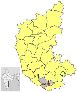
Adibettahalli is in Mysore district
CountryFlag of India.svg  India
State Karnataka
District Mysore
Talukas Tirumakudal Narsipur
Government
  Body Village Panchayat
Languages
  Official Kannada
Time zone IST (UTC+5:30)
ISO 3166 code IN-KA
Vehicle registration KA
Nearest city Mysore
Civic agency Village Panchayat
Website karnataka.gov.in

Adibettahalli is a village in the southern state of Karnataka, India. [1] [2] It is located in the Tirumakudal Narsipur taluk of Mysore district in Karnataka.

Karnataka State in southern India

Karnataka is a state in the south western region of India. It was formed on 1 November 1956, with the passage of the States Reorganisation Act. Originally known as the State of Mysore, it was renamed Karnataka in 1973. The state corresponds to the Carnatic region. The capital and largest city is Bangalore (Bengaluru).

India Country in South Asia

India, also known as the Republic of India, is a country in South Asia. It is the seventh largest country by area and with more than 1.3 billion people, it is the second most populous country and the most populous democracy in the world. Bounded by the Indian Ocean on the south, the Arabian Sea on the southwest, and the Bay of Bengal on the southeast, it shares land borders with Pakistan to the west; China, Nepal, and Bhutan to the northeast; and Bangladesh and Myanmar to the east. In the Indian Ocean, India is in the vicinity of Sri Lanka and the Maldives, while its Andaman and Nicobar Islands share a maritime border with Thailand and Indonesia.

Tirumakudal Narsipur City in Karnataka, India

Tirumakudalu Narasipura the temple city of Karnataka, commonly known as T. Narasipura or T.N. Pura, is a panchyath town in Mysore district in the Indian state of Karnataka. The first name refers to the land at the confluence, (trimakuta in Sanskrit at the confluence of the Kaveri, Kabini and Spatika Sarovara. This is the place in South India where Kumbhamela is held every three years. It finds a mention in the Skanda Purana as one of the Trimakuta Kshetras. The word 'Narasipura' is the name of the town, which is derived from the famous Gunja Narasimhaswamy temple that is located on the right bank of the Kabini river. Considered as sacred as Prayag, it is also known as Dakshina Kashi The town finds mention in tourism guides, both as a tourist place and a pilgrimage centre.

Contents

See also

Related Research Articles

Mysore State state of the Indian Union

Mysore State was a separate state within the Union of India from 1948 until 1956 with Mysore as its capital. The state was considerably enlarged in 1956 when it became a linguistically homogeneous Kannada-speaking state in 1956, within the Union of India. It was subsequently incorporated into the state of Karnataka.

Kanakapura city in Karnataka, India

Kanakapura is a city and the headquarters of Kanakapura Taluk in the Ramanagara district in the state of Karnataka, India. Situated 55 km from the city Bengaluru, this city is famous for the production of silk and granite. It is located among the lush green forests of the state of Karnataka and The town is a tourism hotspot and an often visited tourist favorite in the entire state of Karnataka, as it has something for everyone ranging from avid trekkers to history buffs and wildlife enthusiasts.

Malali village in Karnataka, India

Malali is a village in Mysore district, Karnataka, India.

Keregodu is a village in the southern state of Karnataka, India. It is located in the Mandya taluk of Mandya district in Karnataka. panchalingeshwara temple famous temple in keregodu.this village is near to Mandya only 12km.

Algodu is a village in the southern state of Karnataka, India. It is located in the Tirumakudal Narsipur taluk of Mysore district.

Byrapura village in Karnataka, India

Byrapura is a village in the southern state of Karnataka, India. It is located in the Tirumakudal Narsipur taluk of Mysore district.

Gandhaahalli is a village in the southern state of Karnataka, India. It is located in the Krishnarajanagara taluk of Mysore district in Karnataka.

Kesare is a village in the southern state of Karnataka, India. It is located in the Mysore taluk of Mysore district.

Kestur is a village in the southern state of Karnataka, India. It is located in the Krishnarajanagara taluk of Mysore district.

Udburu is a village in the southern state of Karnataka, India. It is located in the Mysore taluk of Mysore district in Karnataka.

Virapapur is a village in the southern state of Karnataka, India. It is located in the Sindhnur taluk of Raichur district.

Achanalli is a village in the southern state of Karnataka, India. It is located in the Sirsi taluk of Uttara Kannada district in Karnataka.

Adaganahalli village in Karnataka, India

Adaganahalli is a village in the southern state of Karnataka, India. It is located in the Krishnarajanagara taluk of Mysore district.

Adaguru village in Karnataka, India

Adaguru is a village in the southern state of Karnataka, India. It is located in the Krishnarajanagara taluk of Mysore district.

Adahalli village in Karnataka, India

Adahalli is a village in the southern state of Karnataka, India. It is located in the Athni taluk of Belgaum district in Karnataka.

Yachenahalli village in Karnataka, India

Yachenahalli is a panchayat town in Mysore district in the state of Karnataka, India.

Kodalu is a village in the southern state of Karnataka, India.

Kallahalli

Kallahalli is a village in Mysore district of Karnataka state, India.

Bherya

Bherya is a village in Mysore district of Karnataka State, India.

Korahalli Village in Karnataka, India

Korhalli is a large village located in Sindagi Taluk in Bijapur District of Karnataka State, India.

References

  1. "Census of India : List of Villages Alphabetical Order > Karnataka". Registrar General & Census Commissioner, India. Retrieved 2008-12-18.[ permanent dead link ], Census Village code= 2887200
  2. "Yahoo! maps India :". Archived from the original on 2008-12-18. Retrieved 2009-04-17. Adibettahalli, Mysore, Karnataka

Coordinates: 12°08′N76°55′E / 12.133°N 76.917°E / 12.133; 76.917

Geographic coordinate system Coordinate system

A geographic coordinate system is a coordinate system that enables every location on Earth to be specified by a set of numbers, letters or symbols. The coordinates are often chosen such that one of the numbers represents a vertical position and two or three of the numbers represent a horizontal position; alternatively, a geographic position may be expressed in a combined three-dimensional Cartesian vector. A common choice of coordinates is latitude, longitude and elevation. To specify a location on a plane requires a map projection.