
Kolar district is a district in the state of Karnataka, India.

Mysore district, officially Mysuru district, is an administrative district located in the southern part of the state of Karnataka, India. It is the administrative headquarters of Mysore division.Chamarajanagar District was carved out of the original larger Mysore District in the year 1998. The district is bounded by Chamrajanagar district to the southeast, Mandya district to the east and northeast, Kerala state to the south, Kodagu district to the west, and Hassan district to the north.

Hassan is a city in the southern part of the Indian state of Karnataka. It is the headquarters of Hassan district. The city is situated midway between Bangalore and Mangalore on National Highway 75.

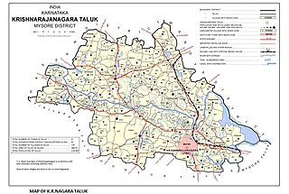
Krishnarajanagara is a town in Mysore district in the Indian state of Karnataka. It is also the administrative center of Krishnarajanagara Taluk.
Konanur is a mid level town in the southern state of Karnataka, India. It is located in the Arkalgud taluk of Hassan district in Karnataka.
Algodu is a village in the southern state of Karnataka, India. It is located in the Tirumakudal Narsipur taluk of Mysore district.
Aspathrekaval is a village in the southern state of Karnataka, India. It is located in the Hunsur taluk of Mysore district.
Byrapura is a village in the southern state of Karnataka, India. It is located in the Tirumakudal Narsipur taluk of Mysore district.
Dhanagahalli is a village in the southern state of Karnataka, India. It is located in the Mysore taluk of Mysore district.
Doddaharve is a village in the southern state of Karnataka, India. It is located 8 km from Bylakuppe.
Elwala or Elavaala is a village in the southern state of Karnataka, India. It is located in the Mysore taluk of Mysore district in Karnataka.
Gandhaahalli is a village in the southern state of Karnataka, India. It is located in the Krishnarajanagara taluk of Mysore district in Karnataka.

Hullahalli is a village in the southern state of Karnataka, India. It is located in the Nanjangud taluk of Mysore district in Karnataka.
Kattemalalavadi is a village in the southern state of Karnataka, India. It is located in the Hunsur taluk of Mysore district in Karnataka.
Kesare is a village in the southern state of Karnataka, India. It is located in the Mysore taluk of Mysore district.
Kestur is a village in the southern state of Karnataka, India. It is located in the Krishnarajanagara taluk of Mysore district.
Koorgalli is a village in the southern state of Karnataka, India. It is located in the Mysore taluk of Mysore district.
Saligrama is a new sub-district of Mysore district, situated on the northern bank of the river Cauvery [Kaveri]. This place is esteemed as sacred by the Shri Vaishnavas on account of its having been the residence of Sri Ramanujacharya. It is the headquarters of Saligrama Taluk. It was established as a new taluk carving out of K.R.Nagar taluk with effect from 31.12.2020 and become ninth taluk of Mysore district of Karnataka, India.

The Karnataka Tamils are a social community of Tamil language speakers living in Bangalore, capital city of the Indian state of Karnataka and Mysore, Mandya, Kolar Gold Fields, Chamrajnagar, and other districts of old Mysore Kingdom. According to The Hindu newspaper, Tamil-speaking settlers migrated to Bangalore in four major waves, the first after the 10th century; the second during the Vijayanagara period; and the third, in the 18th century, after the need for government service required by British East India Company who built the train tracks in Bangalore. Lastly now most Tamilians move to Bangalore for work. However some may say both kannadiga and Tamil were there from the first. According to census 1991, people speaking Tamil as mother tongue in Bangalore formed about 21%. There are 2.1 million Tamils living in Karnataka as of 2011 Census report.

