Administrative divisions of Metro Manila

Last updated

Metro Manila, the capital region of the Philippines, is a large metropolitan area that has several levels of subdivisions. Administratively, the region is divided into seventeen primary local government units with their own separate elected mayors and councils who are coordinated by the Metropolitan Manila Development Authority, a national government agency headed by a chairperson directly appointed by the Philippine president. The cities and municipality that form the region's local government units are further divided into several barangays or villages (formerly called barrios ) which are headed by an elected barangay captain and barangay council.

Contents

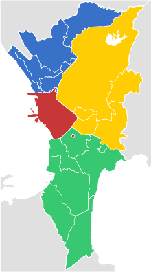
The region as a whole is geographically divided into four districts, of which the first district is the central capital City of Manila, the second and third districts located to the east and north of the City, respectively, and the fourth district covering the remaining areas of the region south of the City and the Pasig River.

Districts

Unlike other administrative regions in the Philippines, Metro Manila is not composed of provinces. Instead, the region is divided into four geographic areas called "districts." [1] The districts have their district centers at the four original cities in the region: the city-district of Manila (Capital District), Quezon City (Eastern Manila), Caloocan (Northern Manila, also informally known as Camanava), and Pasay (Southern Manila). [2] The districts serve mainly to organize the region's local government units for fiscal and statistical purposes.

Districts of Metro Manila Districts of Metro Manila.svg
Districts of Metro Manila
DistrictCities/MunicipalityPopulation (2020)Area
Capital District
(1st District)
Manila 1,846,51342.88 km2
(16.56 sq mi)
Eastern Manila District
(2nd District)
4,771,371236.36 km2
(91.26 sq mi)
Northern Manila District (Camanava)
(3rd District)
3,004,627126.42 km2
(48.81 sq mi)
Southern Manila District
(4th District)
3,861,951208.28 km2
(80.42 sq mi)
Metro Manila 13,484,462619.57 km2
(239.22 sq mi)
Sources:

Cities and municipality

Administrative divisions

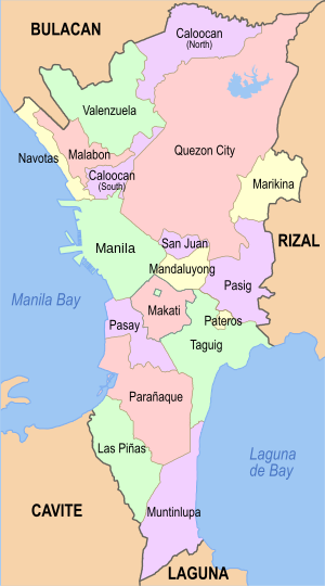
Primary local government units of Metro Manila, 2019 Political map of Metro Manila.svg
Primary local government units of Metro Manila, 2019

The political and administrative boundaries of the National Capital Region has not changed since its formation in 1975 as a public corporation under Presidential Decree No. 824. They are composed of sixteen independent cities, classified as highly urbanized cities, and one independent municipality: Pateros.

Barangays

The cities and municipality of Metro Manila are divided into barangays with populations ranging from under 1,000 to over 200,000. In the City of Manila, Caloocan and Pasay, the barangays are grouped into zones for strategical purposes. As of 2015, there are 1,710 barangays in Metro Manila.

Other divisions

Congressional districts

In terms of congressional representation, the region has 32 congressional districts with each city comprising one or more districts. The lone municipality of Pateros shares a congressional district with the first district of Taguig.

Congressional districts of Metro Manila
City / MunicipalityDistrictArea [10] (km2)Population (2015) [11] Electorate (2016) [12] Representative (2019)
Caloocan 1st 45.441,193,419430,816Dale Malapitan (PDP–Laban)
2nd 7.67390,559218,117Edgar Erice (Liberal)
Las Piñas Lone 32.69588,894304,311Camille Villar (Nacionalista)
Makati 1st 16.31242,655189,215 Romulo Peña Jr. (Liberal)
2nd 15.65339,947208,372Luis Campos Jr. (NPC)
Malabon Lone 15.71365,525194,733Josephine Lacson-Noel (NPC)
Mandaluyong Lone 21.26386,276200,760 Neptali Gonzales II (NUP)
Manila 1st 4.57415,906215,264Manny Lopez (NPC)
2nd 4.08215,457128,781Rolando Valeriano (NUP)
3rd 6.24221,780148,663 Yul Servo (NUP)
4th 5.14265,046151,540Edward Maceda (PMP)
5th 11.56366,714188,080Cristal Bagatsing (PDP–Laban)
6th 7.79295,245142,151 Benny Abante (NUP)
Marikina 1st 9.03178,87594,750 Bayani Fernando (NPC)
2nd 13.62271,866122,961Stella Quimbo (Liberal)
Muntinlupa Lone 39.75504,509309,595 Ruffy Biazon (PDP–Laban)
Navotas Lone 10.77249,463125,795 John Rey Tiangco (Navoteño)
Parañaque 1st 17.06258,210291,067Eric Olivarez (PDP–Laban)
2nd 27.99407,612Joy Tambunting (NUP)
Pasay Lone 13.97416,522253,824Tony Calixto (PDP–Laban)
Pasig Lone 31.00755,300390,923 Roman Romulo (Aksyon)
Pateros–Taguig Lone 24.6440,81533,938 Alan Peter Cayetano (Nacionalista)
Quezon City 1st 19.59409,162184,554Onyx Crisologo (NUP)
2nd 46.27688,773279,166 Precious Hipolito (NPC)
3rd 46.27324,669130,688Allan Reyes (PFP)
4th 23.42446,122186,925Bong Suntay (PDP–Laban)
5th 28.03535,798204,483 Alfred Vargas (PDP–Laban)
6th 21.97531,592164,526Kit Belmonte (PDP–Laban)
San Juan Lone 5.95122,18071,225 Ronaldo Zamora (PDP–Laban)
Taguig Lone 20.61427,940369,095 Lani Cayetano (Nacionalista)
Valenzuela 1st 25.82300,525146,771Weslie Gatchalian (NPC)
2nd 18.69319,897172,160Eric Martinez (PDP–Laban)
Total619.5712,877,2536,253,249Total

Council districts

In terms of Sangguniang Panlungsod (city council, or in the case of Pateros, Sangguniang Bayan or municipal council) representation, each city is divided into city or municipal council districts. These are coextensive to congressional districts above, except that those cities that elect their representative at-large (Las Piñas, Malabon, Mandaluyong, Muntinlupa, Navotas, Pasay, Pasig and San Juan) their city council representation is divided into two districts.

For Taguig, its two congressional districts, with the first district taken without Pateros, are used to determine representation to its city council. For Pateros, it is divided into two districts, independent of Taguig.

Each district sends in an equal number of councilors.

Old districts

Metro Manila cities may also be divided into traditional districts, such as the former municipalities (now city districts) that make up the City of Manila and the historical municipalities and estates like Novaliches, Balintawak, San Francisco del Monte and Diliman that were amalgamated to form Quezon City. Neither division has its own government. In Pasay, traditional districts include Malibay, Santa Clara, San Rafael and Maricaban.

Gated communities

Some cities in Metro Manila may also be divided into several gated communities, also known as subdivisions, which may or may not constitute their own barangays or low-level local government units. Some examples are: Dasmariñas Village in Makati; Ayala Alabang in Muntinlupa; Marina Bay, Merville, Tahanan Village and Better Living Subdivision in Parañaque; Greenhills in San Juan; La Vista, White Plains, BF Homes, Greenmeadows and Filinvest Homes in Quezon City.

Historical divisions

Before 1901

Before 1901, the Province of Manila which today encompasses most of Metro Manila and the northern part of the neighboring province of Rizal was divided into 24 municipalities with Intramuros (then known as Manila) as its capital.

1901–1942

Except for the City of Manila which amalgamated six smaller municipalities in June 1901, the Province of Manila was absorbed by the newly created Province of Rizal with Pasig as its provincial capital.

1942–1947

The City of Greater Manila was formed in January 1942 combining the City of Manila and Quezon City, as well as six other municipalities from Rizal: Caloocan, Makati, Mandaluyong, Parañaque, Pasay and San Juan. [13]

1947–1975

The seven municipalities of the City of Greater Manila were restored and reorganized under the Province of Rizal.

In November 1975 through Presidential Decree No. 824, Metropolitan Manila was created out of four cities and thirteen municipalities (twelve from the province of Rizal and the municipality of Valenzuela from Bulacan) which covers the present-day territory of Metro Manila. [14] It was declared the National Capital Region of the Philippines in June 1978. [15]

Related Research Articles

<span class="mw-page-title-main">Metro Manila</span> Metropolitan area and region of the Philippines

Metropolitan Manila, formally the National Capital Region and commonly called Metro Manila, is the capital region and largest metropolitan area of the Philippines. The region is located on the eastern shore of Manila Bay, between the Central Luzon and Calabarzon regions. It consists of 16 highly urbanized cities: the City of Manila, Caloocan, Las Piñas, Makati, Malabon, Mandaluyong, Marikina, Muntinlupa, Navotas, Parañaque, Pasay, Pasig, Quezon City, San Juan, Taguig, and Valenzuela, and one municipality: Pateros. The region encompasses an area of 619.57 square kilometers (239.22 sq mi) and a population of 13,484,462 as of 2020. It is the second most populous and the most densely populated region in the Philippines. It is also the 9th most populous metropolitan area in Asia and the 6th most populous urban area in the world.

<span class="mw-page-title-main">Makati</span> Central business district city in Metro Manila, Philippines

Makati, officially the City of Makati, is a 1st-class highly urbanized city in the National Capital Region of the Philippines.

<span class="mw-page-title-main">Rizal (province)</span> Province in Calabarzon, Philippines

Rizal, officially the Province of Rizal, is a province in the Philippines located in the Calabarzon region in Luzon. Its capital is the city of Antipolo. It is about 16 kilometres (9.9 mi) east of Manila. The province is named after José Rizal, one of the main national heroes of the Philippines. It is bordered by Metro Manila to the west, Bulacan to the north, Quezon to the east and Laguna to the southeast. The province also lies on the northern shores of Laguna de Bay, the largest lake in the country. Rizal is a mountainous province perched on the western slopes of the southern portion of the Sierra Madre mountain range.

<span class="mw-page-title-main">Pasay</span> Highly urbanized city in Metro Manila, Philippines

Pasay, officially the City of Pasay, is a 1st class highly urbanized city in the National Capital Region of the Philippines. According to the 2020 census, it has a population of 440,656 people.

<span class="mw-page-title-main">Pasig</span> Highly urbanized city in Metro Manila, Philippines

Pasig, officially the City of Pasig, is a highly urbanized city in the National Capital Region of the Philippines. According to the 2020 census, it has a population of 803,159 people.

<span class="mw-page-title-main">Pateros</span> Municipality in Metro Manila, Philippines

Pateros, officially the Municipality of Pateros, is the lone municipality of Metro Manila, Philippines. According to the 2020 census, it has a population of 63,643 people.

<span class="mw-page-title-main">Taguig</span> Highly urbanized city in Metro Manila, Philippines

Taguig, officially the City of Taguig, is a 1st class highly urbanized city in Metro Manila, Philippines. According to the 2020 census, it has a population of 886,722 people. Located in the northwestern shores of Laguna de Bay, the city is known for Bonifacio Global City, one of the leading financial centers of the Philippines. Originally a fishing village during the Spanish and American colonial periods, it experienced rapid growth when former military reservations were converted by the Bases Conversion and Development Authority (BCDA) into mixed-use planned communities. Taguig became a highly urbanized city with the passage of Republic Act No. 8487 in 2004.

<span class="mw-page-title-main">Caloocan</span> Highly urbanized city in Metro Manila, Philippines

Caloocan, officially the City of Caloocan, is a 1st class highly urbanized city in Metro Manila, Philippines. According to the 2020 census, it has a population of 1,661,584 people making it the fourth-most populous city in the Philippines.

The Philippines is divided into four levels of administrative divisions, with the lower three being defined in the Local Government Code of 1991 as local government units (LGUs). They are, from the highest to the lowest:

  1. Regions are mostly used to organize national services. Of the 17 regions, only one—the Bangsamoro Autonomous Region in Muslim Mindanao—has an elected government to which the central government has devolved competencies.
  2. Provinces, independent cities, and one independent municipality (Pateros)
  3. Component cities and municipalities within a province
  4. Barangays within a city or municipality
<span class="mw-page-title-main">Mega Manila</span> Megalopolis in the Philippines

Mega Manila is a megalopolis on the island of Luzon in the Philippines. There are varying definitions of the megalopolis, but it is generally seen as encompassing the administrative regions of Central Luzon, Calabarzon, and Metro Manila. On some occasions, the administrative region of Mimaropa is also included.

<span class="mw-page-title-main">Legislative districts of Rizal</span> Legislative district of the Philippines

The legislative districts of Rizal are the representations of the province of Rizal in the various national and local legislatures of the Philippines. At present, the province is represented in the House of Representatives of the Philippines by its four congressional districts, with the districts' representatives being elected every three years. Additionally, each district is allotted a certain number of seats in the Rizal Provincial Board, with board members also being elected every three years.

The legislative district of Pateros–Taguig is the combined representation of the independent municipality of Pateros and eastern part of the highly urbanized city of Taguig in the Congress of the Philippines. The city and municipality are currently represented in the lower house of the Congress through their lone congressional district.

The legislative districts of Taguig are the representations of the highly urbanized city of Taguig in the Congress of the Philippines. The city is currently represented in the lower house of the Congress through its lone congressional district.
<span class="mw-page-title-main">Manila (province)</span> Philippine province (1571–1901)

Manila, also known as Tondo until 1859, was a province of the Philippines that encompassed the former pre-Hispanic polities of Tondo, Maynila, and Namayan. In 1898, it included the City of Manila and 23 other municipalities. Alongside the District of Morong, it was incorporated into the Province of Rizal in 1901.

<span class="mw-page-title-main">Upper Bicutan</span> Barangay in Taguig City, Metro Manila, Philippines

Upper Bicutan is one of twenty-eight barangays of Taguig City, Metro Manila in the Philippines.

<span class="mw-page-title-main">Outline of Metro Manila</span> Overview of and topical guide to Metro Manila

The following outline is provided as an overview of and topical guide to Metro Manila:

<span class="mw-page-title-main">Index of Metro Manila–related articles</span>

The following is an alphabetical list of articles related to the Philippine capital region of Metro Manila.

<span class="mw-page-title-main">Embo (barangays)</span> Barangays in Metro Manila, Philippines

Embo refers to a collective term for barangays administered in a de facto state by the city government of Makati but de jure of the city government of Taguig after the Supreme Court sided with the City of Taguig denying any further legal remedies to Makati. The barangays were originally established to house military personnel of the Armed Forces of the Philippines. The area is part of the larger disputed Fort Bonifacio area which is claimed by the local governments of Pateros and Taguig. As of April 2023, the barangays are in the process of transition and handover from Makati to Taguig.
References

  1. "Municipal and City Level Estimates" (PDF). National Statistical Coordination Board. Archived from the original (PDF) on 13 November 2013. Retrieved 14 July 2014.
  2. "Environmental Management Bureau – National Capital Region". Environmental Management Bureau. Archived from the original on 25 July 2014. Retrieved 17 July 2014.
  3. 1 2 Census of Population (2020). Table B - Population and Annual Growth Rates by Province, City, and Municipality - By Region. Philippine Statistics Authority . Retrieved 8 July 2021.
  4. "An Update on the Earthquake Hazards and Risk Assessment of Greater Metropolitan Manila Area" (PDF). Philippine Institute of Volcanology and Seismology. November 14, 2013. Retrieved May 16, 2016.
  5. "Enhancing Risk Analysis Capacities for Flood, Tropical Cyclone Severe Wind and Earthquake for the Greater Metro Manila Area Component 5 – Earthquake Risk Analysis" (PDF). Philippine Institute of Volcanology and Seismology and Geoscience Australia . Retrieved May 16, 2016.
  6. Pateros; Land Use Classification
  7. "An Update on the Earthquake Hazards and Risk Assessment of Greater Metropolitan Manila Area" (PDF). Philippine Institute of Volcanology and Seismology. November 14, 2013. Archived from the original (PDF) on June 24, 2016. Retrieved May 16, 2016.
  8. "Enhancing Risk Analysis Capacities for Flood, Tropical Cyclone Severe Wind and Earthquake for the Greater Metro Manila Area Component 5 – Earthquake Risk Analysis" (PDF). Philippine Institute of Volcanology and Seismology and Geoscience Australia. Archived (PDF) from the original on August 6, 2016. Retrieved May 16, 2016.
  9. "Land Use Classification". Municipality of Pateros. Archived from the original on September 15, 2008. Retrieved April 7, 2016.
  10. "List of Provinces". PSGC Interactive. National Statistical Coordination Board. Archived from the original on April 19, 2016. Retrieved April 8, 2020.
  11. "Population Counts by Legislative District (Based on the 2015 Census of Population)". Philippine Statistics Authority. July 11, 2016. Retrieved May 2, 2020.
  12. "Philippine 2016 Voters Profile by Province and City / Municipality". Commission on Elections. January 7, 2016. Retrieved May 2, 2020.
  13. "Executive Order No. 400, s. 1942". Official Gazette of the Republic of the Philippines. Retrieved 17 July 2014.
  14. "Presidential Decree No. 824, s. 1975". Official Gazette of the Republic of the Philippines. Retrieved 17 July 2014.
  15. "Presidential Decree No. 1396, s. 1978". Official Gazette of the Republic of the Philippines. Retrieved 22 September 2015.