
Laguna de Bay, also known as Laguna Lake and alternatively spelled "Laguna de Bae", is the largest lake in the Philippines. It is located southeast of Metro Manila, between the provinces of Laguna to the south and Rizal to the north. A freshwater lake, it has a surface area of 911–949 km2, with an average depth of about 2.8 meters and an elevation of about one meter above sea level. The lake is shaped like a crow's foot, with two peninsulas jutting out from the northern shore and filling the large volcanic Laguna Caldera. In the middle of the lake is the large island of Talim.

The Pasig River is a water body in the Philippines that connects Laguna de Bay to Manila Bay. Stretching for 25.2 kilometers (15.7 mi), it bisects the Philippine capital of Manila and its surrounding urban area into northern and southern halves. Its major tributaries are the Marikina River and San Juan River. The total drainage basin of the Pasig River, including the basin of Laguna de Bay, covers 4,678 square kilometers (1,806 sq mi).

Pasig, officially the City of Pasig, is a highly urbanized city in the National Capital Region of the Philippines. According to the 2020 census, it has a population of 803,159 people.

Marikina, officially the City of Marikina, is a 1st class highly urbanized city in the National Capital Region of the Philippines. According to the 2020 census, it has a population of 456,159 people.

Taguig, officially the City of Taguig, is a coastal city located in eastern shores of Metro Manila. It is the fifth-most populous city in the Philippines with a population of 1.2 million people. The city is one of the Philippines' cultural, financial, high-tech, entertainment and media centers with significant influence on commerce, health care, research, technology, education, politics, tourism, dining, art, fashion, and sports. Taguig is also an important center for the country's international diplomacy, hosting several embassies. The city also home to the headquarters of several major multinational corporations. Taguig has the fourth largest skyline in the Philippines, with 289 high-rises, 80 of which exceed 100 m (328 ft).
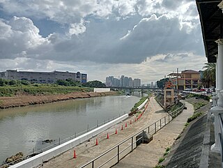
The Marikina River is a river in eastern Metro Manila, Philippines. It is the largest tributary of the Pasig River, with headwaters located in the Sierra Madre Mountains in Rodriguez, Rizal province.
The Sapang Baho River is a river system that runs through Rizal Province and Marikina in the Philippines. The name, when literally translated, means "smelly creek". It is one of 21 tributaries of Laguna de Bay and is regularly monitored by the Laguna Lake Development Authority (LLDA) through one of its 15 river monitoring stations. Among its headwaters are the Hinulugang Taktak falls on the Taktak River in Antipolo city, once a famed tourist destination in the days before urbanization and pollution.

Typhoon Ketsana, known in the Philippines as Tropical Storm Ondoy, was the second-most devastating tropical cyclone of the 2009 Pacific typhoon season, causing $1.15 billion in damages and 665 fatalities, only behind Morakot earlier in the season, which caused 956 deaths and damages worth $6.2 billion. Ketsana was the sixteenth tropical storm, and the eighth typhoon of the season. It was the most devastating tropical cyclone to hit Manila, surpassing Typhoon Patsy (Yoling) in 1970.

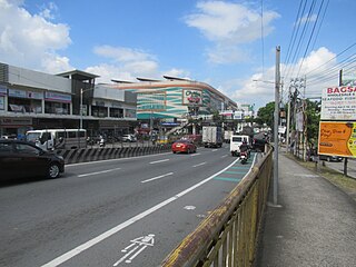
Ortigas Avenue is a 12.1 km (7.5 mi) highway running from eastern Metro Manila to western Rizal in the Philippines. It is one of the busiest highways in Metro Manila, serving as the main thoroughfare of the metro's east–west corridor, catering mainly to the traffic to and from Rizal.
The Laguna Lakeshore Expressway Dike is a proposed expressway in the Philippines that will start from the coastal area of Laguna de Bay from Taguig in Metro Manila to Calamba and Los Baños in Laguna.
The 2012 Luzon southwest monsoon floods, was an eight-day period of torrential rain and thunderstorms in Luzon in the Philippines from August 1 to August 8, 2012. Its effects centered on Metro Manila, the surrounding provinces of the Calabarzon region and the provinces of Central Luzon. Not a typhoon in its own right, the storm was a strong movement of the southwest monsoon caused by the pull of Typhoon Saola (Gener) from August 1–3, strengthened by Typhoon Haikui. It caused typhoon-like damage: the most damage caused by rain since September 2009, when Typhoon Ketsana (Ondoy) struck Metro Manila. The heavy rain caused the Marikina River to overflow, destroying areas also affected by Ketsana, triggering a landslide in the Commonwealth area and collapsing the northbound Marcos Highway.

The Upper Marikina River Basin Protected Landscape is a protected area in the Province of Rizal in the Philippines, which forms the upper area of the drainage basin of the Marikina River.
Slums are traditionally described as dense urban settlements, usually displaying characteristics such as crowded and compact housing units, informal delivery of utilities, and unofficial recognition by local government. In the Philippines, residents of slum areas are commonly referred to as "squatters" and have historically been subject to relocation or forced demolition. With a steadily growing metropolitan area, Metro Manila is subject to a densifying population of slum dwellers—a 2014 article states that Manila has an estimated 4 million people living in slums, out of a total population of 21.3 million.

Circumferential Road 6 (C-6), informally known as the C-6 Road, is a network of roads and bridges that all together will form the sixth and outermost beltway of Metro Manila in the Philippines once it is completed.

The following outline is provided as an overview of and topical guide to Metro Manila:
Radial Road 5, more commonly referred to as R-5, is a network of roads and bridges that all together form the fifth radial road of Manila in the Philippines. The road links the City of Manila with Mandaluyong and Pasig in the east, leading out of Metro Manila into the province of Rizal and south towards Laguna. It is the only arterial road traversing the east side of Laguna de Bay.

The following is an alphabetical list of articles related to the Philippine capital region of Metro Manila.

Napindan, officially Barangay Napindan, is one of the 38 barangays of Taguig, Metro Manila, Philippines. As of the 2020 census, the population was 24,437. It was one of the earlier barrios that was added to Taguig during the Spanish colonial period.

Circulo Verde is a mixed-use development in Quezon City, Metro Manila, the Philippines. It is a primarily residential enclave on a meander of the Marikina River in the village of Bagumbayan on Quezon City's border with Pasig. The 12.47-hectare (30.8-acre) riverfront community is a redevelopment of the former cement plant owned by Concrete Aggregates Corp., a subsidiary of Ortigas & Company. It is one of the four major estates owned and developed by the company in Metro Manila, which in 2019 maintained a combined land bank of 50 hectares across the Eastern Manila cities of Mandaluyong, Pasig and Quezon City.


