Niger is a landlocked nation in West Africa located along the border between the Sahara and Sub-Saharan regions. Its geographic coordinates are longitude 16°N and latitude 8°E. Its area is 1.267 million square kilometers, of which 1 266 700 km2 is land and 300 km2 water, making Niger slightly less than twice the size of France.

Niger's transport system was underdeveloped during the colonial period (1899–1960), mainly relying on animal, human, and limited river transport in the far southwest and southeast. No railways were constructed in the colonial period, and roads outside the capital remained unpaved. The Niger River is unsuitable for large-scale river transport, as it lacks depth for most of the year and is interrupted by rapids in many areas. Camel caravan transport was historically crucial in the Sahara desert and Sahel regions, which cover most of northern Niger. It is also utilized in the Sahel where the capital city Niamey is.

Niamey is the capital and largest city of Niger. Niamey lies on the Niger River, primarily situated on the east bank. Niamey's population was counted as 1,026,848 as of the 2012 census. As of 2017, population projections show the capital district growing at a slower rate than the country as a whole, which has the world's highest fertility rate. The city is located in a pearl millet growing region, while manufacturing industries include bricks, ceramic goods, cement, and weaving.

The regions of Niger are subdivided into 63 departments. Before the devolution program on 1999–2005, these departments were styled arrondissements. Confusingly, the next level up (regions) had, before 2002-2005 been styled departments. Prior to a revision in 2011, there had been 36 departments. A draft law in August 2011 would expand that number to 63. Until 2010, arrondissements remained a proposed subdivision of departments, though none were used. The decentralisation process, begun in the 1995-1999 period replaced appointed Prefects at Departmental or Arrondissement level with elected councils, first elected in 1999. These were the first local elections held in the history of Niger. Officials elected at commune level are then selected as representatives at Departmental, regional, and National level councils and administration. The Ministry of Decentralisation was created to oversee this task, and to create a national consultative council of local officials.

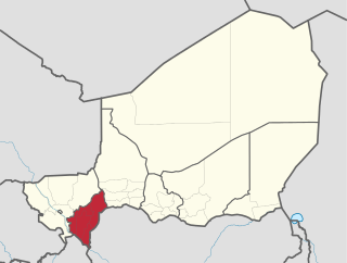
Dosso is one of the eight Regions of Niger. The region has an area of 31,002 square kilometres (11,970 sq mi), with a population of 2,078,339 as of 2011.

Tahoua is one of eight Regions of Niger. The capital of the region is the commune of Tahoua. The region covers 106,677 km².

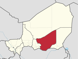
Zinder Region is one of the seven regions of Niger; the capital of the region is Zinder. The region covers 145,430 km². It is the most populous province of Niger.

Tillabéri is one of the eight Regions of Niger; the capital of the Region is Tillabéri. Tillabéri Region was created in 1992, when Niamey Region was split, with Niamey and its immediate hinterland becoming a new capital district enclaved within Tillabéri Region.

The Region of Maradi is one of seven regions of Niger. It is located in south-central Niger, east of the Region of Tahoua, west of Zinder, and north of the Nigerian city of Katsina. The administrative centre is at Maradi. The population of the Region is predominantly Hausa.

The Departments of Niger are subdivided into communes. As of 2005, in the seven Regions and one Capital Area, there were 36 départements, divided into 265 communes, 122 cantons and 81 groupements. The latter two categories cover all areas not covered by Urban Communes or Rural Communes, and are governed by the Department, whereas Communes have elected councils and mayors. Additional semi-autonomous sub-divisions include Sultanates, Provinces and Tribes (tribus). The Nigerien government estimates there are an additional 17000 Villages administered by Rural Communes, while there are over 100 Quartiers administered by Urban Communes.

Abdou Moumouni University, formerly the University of Niamey from 1974 to 1994, is a public university based in Niamey, the capital of Niger. The main campus is situated on the right bank of the Niger River. Historically, its students and faculty have been involved in protest movements in the capital.

The following outline is provided as an overview of and topical guide to Niger:

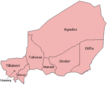
Niger is divided into eight regions, each of which is named after its capital.

The government of Niger is the apparatus through which authority functions and is exercised: the governing apparatus of Nigerien state. The current system of governance, since the Constitution of 25 November 2010, is termed the Seventh Republic of Niger. It is a semi-presidential republic, whereby the President of Niger is head of state and the Prime Minister of Niger head of government. The officials holding these posts are chosen through a representative democratic process of national and local elections, in the context of a competing multi-party system. Executive power is exercised by the government. Legislative power is vested in both the government and the National Assembly. The judiciary is independent of the executive and the legislature: its Constitutional Court has jurisdiction over constitutional and electoral matters.
Republic Day, a national holiday in the Republic of Niger is commemorated on 18 December 1958.

The Société Nigérienne de Transports de Voyageurs or SNTV is the Nigerien government owned bus and public transport company.
The vehicle registration plates of Niger is a legal form requiring the citizens of Niger to have the car registered.
The 2018 Coupe nationale du Niger is the 43rd edition of the Coupe nationale du Niger, the knockout football competition of Niger.

In 2021, Niger has been affected by subsequent floods due to heavy rains, causing several deaths and widespread damage nationwide. Niamey is the most affected area. At least 62 people died, 60 were injured and 105,690 individuals have been affected by the floods. Most fatalities were reported in Maradi Region with 18 deaths.


